Friday, July 31, 2015

Finishing Our "Triathlon"


We came to the area around Gunnison because we had never visited here before, and we stayed at Blue Mesa Recreation Ranch because it was free.  It’s a membership park that offers 3 free nights in their campground in exchange for listening to their sales pitch.  Perhaps we will invest in a camping membership at some point, but it wasn’t today.  

In the 3 days we have been in the area, we have biked (in Crested Butte), hiked (into the Black Canyon), so all we lacked in our triathlon events was the water portion.  Actually, Denisa hit the water at the nice pool at the RV resort, but that didn’t count.   

We needed some kayak time on Blue Mesa Lake!  At 20 miles long with 94 miles of shoreline, it is the largest lake in Colorado.  We also found it to be clear and deep, and a beautiful lake for kayaking.  It’s as blue in person as the pictures we had seen.


Because we didn’t purchase the membership plan, we had to be out of our space the third morning.  So we parked the motor home at the lake’s visitor center, and drove the car to a lake access spot at the neck of Soap Creek Arm.  We have learned that we enjoy kayaking little inlets more than the main body of large lakes.  But this lake was so big that even the “little inlets” were a mile across.


We just talked about the fact that we hadn’t seen any birds on the lake, when Mark spotted a Mother duck and her 7 little ducklings.  They were so cute, but impossible to photograph in the shadows at the edge of the lake.  Then we found a pair of geese and their five adolescent goslings.
They let us get very near to take pictures, and we were especially entertained by the fifth gosling that was always last in line because he was so busy eating.

We followed the goose parade as they led us towards the mountains in front of us.


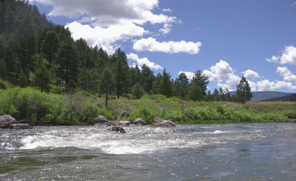
The peaks at the end of the inlet made a very pretty focal point to row towards.  It’s hard to capture the grandeur of these great mountains.  But if you look carefully in the left hand quarter of the picture, you can see a tiny white box on the shore.  That tiny box would be a full-size motor home, dwarfed by another of God’s wonders.


After a nice float on a beautiful weather morning, we had completed the last event of our "triathlon."  We have biked, hiked and kayaked this area of Colorado, so it is time to head down the road.  We returned to the visitor center to pick up our motor home and headed to our next destination—Black Canyon of the Gunnison National Park.


Curecanti National Recreation Area


Again, we found a national recreation area that we had never heard of, and cannot pronounce--Curecanti National Recreation Area.  It includes Blue Mesa Lake, as well as miles of canyon carved by the Gunnison River.  As you can tell from the blue in the picture, the lake is true to its color name.  
Blue Mesa Lake stretches for twenty miles, but our favorite view is with the mountain named "The Pinnacles" behind the lake.

Curecanti National Recreation Area also includes many miles of the 48-mile canyon carved by the Gunnison River.  We took two nice hikes into that canyon.

The goal of the first hike was to look for a possible spot to put our kayak into the river.  Just below the dam is a boat landing, with only a few obstacles for a wonderful kayak trip. 


Obstacle one would be the 232 steps that we would have to carry the kayak down (and of course back up).  Obstacle two would be the hard flow of the river right below the dam because they were releasing water from the lake.  This area has been blessed with good rains that are making a difference in the drought conditions they have endured in recent years.  Paddling back upstream against that current would be very hard.  So instead of kayaking, we opted for a hike along the river.

This is actually the same route that people taking the ranger-led pontoon boat tour of the river would take.  In fact, we saw the boat as it was leaving on its 2-hour tour.
What we didn’t realize, was that while we were taking a picture of the boat, we accidentally took a picture of a bear on the other side of the canyon.  All the passengers were watching the bear climbing up the canyon wall.  The bear didn't show up well in the picture because he was in the shadows on the right hand side of the picture, but it was fun for us to see him on the OTHER side of the river.


We also discovered that instead of wild strawberries, this canyon has wild raspberries.  The ranger thought the bear was probably hunting berries today, so Denisa was trying to eat the “bear food” before he decided to come to our side of the canyon to get it.  She tried to convince Mark that all her stops for berries were only for his protection. The raspberries were tiny but tasty.
After exploring this area on the south rim of the canyon, we drove to the north rim.  We stopped at various view points, and found that the further west we drove, the deeper the canyon walls were.


It was interesting to see the rolling plains at the top of those tall canyon walls.  We imagined the surprised look of the explorers riding over those plains hundreds of years ago and finding that gaping hole of a canyon suddenly appear before them.
Pioneer Point was our favorite view point, and the views down were spectacular.

We also made a stop further west for another great look of the canyon and Gunnison River at Hermits Rest viewpoint.
After seeing all we could from the top, we vowed to return for the hike down to the bottom of the canyon on another day.  “Another day” dawned with cloudy skies, but we have found that we can hike in the rain.  So we gathered up our rain gear and went on a hike.   You can barely see Denisa in the rainy haze at the bottom right corner of the picture as we started the trek down.
In spite of the rain, we headed down the two-mile trail that would descend 900 feet in elevation along the Curecanti River.


There were several beautiful distractions along the way, including an interesting tree to climb and take a break in.
We followed the Curecanti River for most of the hike.  Since we were hiking down 900 feet, the river's steep path made for great waterfalls.  It was another of God's wonders to walk beside a continuous waterfall that rambled along the canyon wall for a quarter of mile.  It was deafening at times.  What a great hike!

When we reached the bottom of the canyon, we could look up 900 feet to spot the viewing point that we had looked down from the day before.
As we reached the bottom of the canyon, we were surrounded on both sides by massive walls.  The views would have been better without the rain, but it was wonderful to make it to the bottom.


The Curecanti River eventually emptied into the wide Gunnison River at the bottom of the canyon.  It was amazing to now be looking up at Curecanti Needle that we had looked down at from the Pioneer Point viewpoint.

At the bottom of the canyon is a camping spot for hikers that would like to enjoy this little slice of heaven overnight.  There's even a privy in the woods, and a metal bear box chained to a tree to keep food supplies safe from the wildlife. This would be a good place to stash those delicious wild raspberries.

But today it was raining occasionally, and you can clearly see the raindrops hitting the River at the base of the canyon.

So we headed back out of the canyon.  You can barely see Denisa making her way over the river bridge, trying to dodge the raindrops.

We found that the foliage in the canyon was heavy enough to form an umbrella from the rain.  So when we found dry areas, we waited out the showers.  It made for a slow trip out of the canyon, but it kept us from getting tired as we made our way up those 900 feet in elevation.  The nice thing about being retired, is that we didn't have to hurry to the top since we didn't have to be back to work the next day.

On this rainy day we had met another hiker on the trail that was going down to the bottom as we were hiking out.  He and his dog were both outfitted in orange rain gear, so they were easy for us to spot at the very bottom when we made it to the top.   The picture we took, however, was not detailed enough to show them clearly.  So Mark worked a little magic to enlarge the hiker and move him to the box in the bottom left of the following picture.  The red lines point to his actual position in the picture beside the stream.


The views from the top are great, but the views are even better from the bottom.  There are great hikes into the canyon at Curecanti National Park!

Tuesday, July 28, 2015

Biking Crested Butte

After three weeks in South Fork, it was time to move north to new adventures.  But on the way out of the area, we stopped at a local shop to pick up a variety of those beloved Amish fried pies.  We bought one of every kind they had that morning--blackberry, apple, cherry, lemon, strawberry rhubarb, peach, and raspberry.  We showed enough restraint to put some into the freezer, and we only got two in this picture. 

We moved a couple hours down the road toward Gunnison, Colorado.  But on the way we had to go over the 10,149 feet North Pass, and down thru a national forest canyon with a daunting sign announcing curvy roads for the next 15 miles.  Also, notice that the state of Colorado wasted no asphalt on this narrow road.  Mark did a great job driving this road that looked like a snake had designed it.

We finally arrived at Blue Mesa Recreation Ranch--12 miles west of Gunnison, Colorado.  We have never been in this part of Colorado so we are anxious to explore new territory.  The first place we decided to visit was Crested Butte, and the majestic mountain that welcomes everyone to town.

We had heard that this was a beautiful little mountain town, and we would have to agree.  We stopped by the visitor center, and got great advice for a ride that was perfect for bikers that love the mountains but don't like to tackle those inclines on two wheels.  This trail took us beside mountain lakes,

and we always had mountain peaks right in front of us.

Soon we were riding beside a mountain stream.  Could this bike ride get any better?

The name of this bike trail is "Lower Loop" and is listed as a beginner trail.  We saw families of all ages on the path.  The further we got from town, the more narrow the bike path became, as we rode through mountain meadows and forests.  You can barely see Denisa on her bike, pedaling down the single track trail in the bottom center of the picture.

 We had beautiful blue skies ahead of us as we pedaled further out of town.

But when we turned back towards Crested Butte, we saw that a storm was building.  

It was a quick glance at Slade River before we had to race to get back to town before we got wet.

Crested Butte is a town at the end of a highway.  Highway 135 literally ends in town, and the only other way out of town is a gravel road.  So we are amazed that so many people were in Crested Butte on this Wednesday afternoon.  Maybe some were still visiting because of the Wildflower Festival last weekend.  Crested Butte is the "Wildflower Capitol of Colorado" and the fields outside of town were beautiful.


If you throw in a mountain peak and a lake, you realize that you are blessed with another of  God's wonders.


Just north of Crested Butte is Mt. Crested Butte, home of the ski resort.  You can see the ski runs and the chair lifts that make their way down the face of the mountain.

The rain storms had already dumped their afternoon showers that keep these mountain meadows so green, and we had blue skies once more.

We had a beautiful day in Crested Butte, but it felt too crowded and expensive for a long stay in the summer.  We couldn't find a place to park in historic downtown, and we saw too many $16 hamburgers on the menus of the restaurants in  town.  It's a nice place to visit, but we're not sure we could afford to live there.


Saturday, July 25, 2015

Waterfalls and Water Rafting in South Fork

When we first move to a new area, we makes a mental list of things we would like to do before we leave.  That list usually gets longer as we talk to more locals and learn more interesting things in the area.  After being in South Fork for almost three weeks, our list was very long.  So the last few days were busy trying to conquer "the list."  Because we have had such cool temperatures and rain showers almost every afternoon, two of our water activities were last on the list.  It was time to conquer the water!

We finally headed north on highway 149 towards two waterfalls that had been recommended.  On the way, there was a stop at the headwaters of the Rio Grande River.  We have been following this great river since February when we camped a few miles from it.    We saw where it ended at the Gulf of Mexico, and now we have seen where it begins.


Our destination was the North Clear Creek waterfall, between the towns of Creede and Lake City.  It's a beautiful highway drive with some great water at the end.  You can barely see Mark at the top of the waterfall.  If you look closely, you can also see a family in the grassy area in the bottom left of the photo.  They made a very difficult hike to get to the base of the waterfall.  We would talk to them later so we could email them the pictures we had taken from the top.  It's a small world, because they are from the tiny town of Vici, Oklahoma, very close to our home town.

We started that difficult hike to the bottom.  We climbed down the trail into the canyon and scrambled over enough boulders to get a view of the waterfall from the bottom.  We decided we weren't as tough as the young guys that made it all the way to the falls.  (Actually Mark said we were tough enough, just not motivated enough today.)

The next stop was just a few miles through the mountains to the South Clear Creek waterfall.  Less known and harder to access, we had this beautiful canyon with its roaring river to ourselves.

The south falls were actually more spectacular, but harder to photograph.  Mark wanted to climb out on the rocks to get a good picture, but his parents will be glad that Denisa stopped him.  This was the best shot we could get of just a piece of the falls--another one of God's wonders.
In case we hadn't seen enough water, it started falling from the sky.  We have learned that a good tree is the best protection from these passing storms (as long as it doesn't include lightning).  We believe this is an Engelmann Spruce, so it was a fitting place for a couple Engelmans to hang out from the rain.

Most of these mountain showers are over quickly, so we were back to sit by the waterfall and the clear skies.

The last day we were in South Fork was our last water activity--floating the Rio Grande River.  We have been camped just a quarter mile from the river for almost three weeks, and Denisa has been waiting for this float trip for a long time!  We got a ride to an easy put-in spot just 6 miles from our RV park.  Thanks Kevin!  He also gave us some expert advice on the river that he has enjoyed for many years. 

It takes us about ten minutes to get our inflatable kayak ready for the water, and we have enjoyed so many beautiful places with it.  The mountain scenery during the first part of the float was great!


The only other boaters we saw on this stretch of the river were a couple that was fishing with a guide.  Denisa prefers her guide and main rudderman--Mark.


We have heard that by this time of the summer the water can be too low (or the rocks too high) for a good ride.  We could see a few rocks, but the rudder man avoided (most of) them.


We had a great float and it was nice to let the river current provide the locomotion for this boat trip.  Too soon we were back to the take out point, just a short walk away from home.  We love living so close to a mountain river!

South Fork has been a great cool place to spend most of the month of July, and we have enjoyed the friends we have met at Aspen Ridge RV Park.  We feel like we have been blessed and we have found our treasure at the end of the rainbow.