We are loving Moab, Utah, where we can drive four miles outside of town and be in Arches National Park. We have made multiple trips there, where we are greeted by the tall fins of red rock.
We have been going very early or very late in the day to avoid the afternoon heat. That also gives us the best lighting. The red rock almost glows as the rising sun hits it. We don't usually set the alarm clock to wake up, but that darn alarm going off at 5:30 is worth it to have a cool temperature hike and all this beauty all to ourselves.
It's hard to describe the grandeur of this place because it doesn't all fit into a camera frame. To give some scale to it, Mark ran up beside this huge rock formation that is part of Courthouse Towers. You'll be hard pressed to find him, but he is standing at the bottom left of the closest mountainous fin in the next picture. He's a tiny light-colored speck next to the Courthouse.
Here is a zoomed-in fuzzy picture of him, and there is all that beautiful red sandstone looming over his head.
You can walk among all the huge red rock spires on a one-mile trail named Park Avenue. Just like in New York City, walking on Park Avenue is a journey among the sky scrapers.
Some of those sky scrapers have names. This one is called "The Three Gossips."
After this first section of the national park, we found the arches that it is named for. There are 2000 arches in this national park--the most of any area in the world. We visited a few of those arches in the Windows section this morning, and got a picture of Denisa standing in the North Window Arch.
Mark moved back so that he could picture both the south and north windows (with Denisa still standing under the arch) and together they form a Lone Ranger-like mask. Denisa didn't volunteer to pose under the arch until she realized that the photographer would get the most exercise when picturing this arch.
On the same trail is the Turret Arch. This is another two-for-one stone since there is the little window to the left, and the huge opening on the right. Because of the dark shadow behind him, Mark is easy to see in that biggest arch. We love these blue skies and morning sun lighting up the red sandstone!
We saw three buses pull up in the parking lot, so we made a run for the last arch in this area--Double Arch. These two giant spans are joined at one end. You can see that Mark got the most exercise (again), and he beat the bus-loads of foreign travelers to get this picture all alone under the arches. We don't know how the bus drivers get all those people loaded on a bus so early in the morning, but we are impressed by the rigid schedules these bus travelers keep.
Those overhead arches are massive!
Our last stop this morning was to Balanced Rock. Because it is on the main road of the park, close to 100% of all visitors will stop here. It is dwarfed by the other rock formations around it, so in this picture it looks quite small.
That is why we try to sneak a person into each picture, just to bring scale to these "tiny" formations. Denisa read that Balanced Rock is basically the size of three buses. That's funny, all of those travelers and their buses at the last stop could have been balanced over Denisa's head.
It wasn't even noon, but it was getting warm and the park was getting crowded. We had hiked several miles and had wandered through some awesome wonders. It was time to hunker down in the motor home for a nap and a nice meal. Have we mentioned lately that we love this retirement life we are leading?
Moab is a mecca of outdoor activity, and we are loving our time here. Besides Arches National Park, we found that Canyonlands National Park is around 30 miles from Moab. So we headed southwest early one morning, and arrived at Canyonlands before the visitor center even opened. The good news is that we get to visit another national park. But the bad news is that the jet stream has brought to Utah the smoke from the forest fires plaguing the northwestern United States. Our view into the canyon will be hazy today, but the layers of canyon walls are still interesting.
Canyonlands National Park is sliced into four districts by the Colorado and Green Rivers that run through it. Today we are at the most-visited "Island in the Sky" section. The ranger gave us best advice on how to attack this national park, and we followed his plan. First stop was the "Upheaval Dome." Scientists haven't determined if this giant hole was caused by a meteor or a salt dome collapse, but we determined it was huge.
We took the 1.8 mile hike to the best viewpoint of the upheaval. Along the way there were huge boulders to climb, and so (of course) Mark did just that. You can barely see him on top of the rock formation on the far left side of the picture.
This is a colorful national park. There is the Green River, the Orange Cliffs, the White Rim . . . We also found that the local lizards are colorful, having taken on the orange color of those cliffs.
Mark's hikes are usually longer than Denisa's hikes because he likes to climb on boulders. He always wants to see what's on the other side, or what's inside that crevice. So far he hasn't fallen off the other side or gotten bit from inhabitants of those crevices.
As we left this section of the park, we spotted a raven with a pine cone from a pinyon tree. We knew that there are pinyon nuts in these cones, and the raven was working hard to get them out. He would hold the green pine cone with his foot while hammering the hard nuts out of their shells with his beak.
The ranger's second destination is the "Grand View Point Overlook." It's a 2-mile hike along the canyon edge to get to the most southern tip of this great canyon. As we hiked on the east side of the point we could look down on the White Rim, a continuous sandstone bench 1,200 feet below. Another 1,000 below the White Rim is the Colorado River. This broad mesa is really an island in the sky.
The big boulders along the edge are fun to climb, and have an added bonus of danger since they could plunge into the canyon below at any time.
There are interesting shapes in the rock formations along the trail. What does that rock look like?
That is obviously a cowboy hat rock, and it just happens to be the perfect size.
We made it to the very tip of the Grand View Point, and this photo is proof. To the east we can see the Colorado River, and to the west is Green River. The confluence of the two rivers is in front of the Grand View Point. The smoke in the air made the canyon views of the Orange Cliffs hazy, but Mark and Denisa were pretty clear. This picture was taken by a Mother and daughter from Germany that were traveling all over the United States this summer. We have met so many foreign tourists in the national parks! Interesting note, they were from Oldenburg, Germany, the same town that Mark's ancestors are from. They were either too confused by our question, or perhaps ashamed to admit if they knew of any Engelmans still living in Oldenburg.
There was also a throne-like dead tree along the trail for another fun photo opportunity.
The third ranger suggestion was to take the half-mile hike to see the only arch in the park. So we made the short hike to see Mesa Arch. Noted for being a great place to see the LaSal Mountains, we could only see smoke in the air today.
A nice couple from Michigan offered to take our picture under the arch, so we got two pictures in one day!
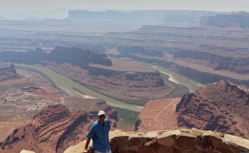
After seeing the highlights of Canyonlands National Park, we still had time to make the 10 mile trip over to Dead Horse Point State Park. The hike to the edge of the mesa gave great views 2000 feet below to the
Colorado River winding its way through the valley below. There was a
horse-shoe bend right in front of the view point.
The curious name for this park comes from the fact that cowboys used to herd wild mustangs to the end of this high mesa. They would build
a temporary fence across the 30-yard neck of the mesa and then choose the
best horses to keep. According to the legend, one time the culled horses
were just left in their temporary pen at the end of the mesa, where
they thirst to death.
Living close to Arches National Park makes us notice arches are every where. We spotted this huge arch that no one else even noticed.
Or maybe Mark just photo-shopped that picture of Denisa into that tiny arch under a small ledge. The actual size of the arch can be seen in the photo below.
One of the interesting sections of Dead Horse State Park can only be seen from afar. Those two squares of blue water in the distance below are actually giant evaporation pools. Potash is a salt found naturally in this area. A local company pumps water into the rock formation that holds the potash. This salty potash water is then pumped into the evaporation pools, where the sun will remove the water. The potash is then scraped out of the pool, and will be used as plant fertilizer. We're getting so smart from all this traveling we're doing!
We've learned something today. We've enjoyed some wildlife. We've hiked over six miles and got good exercise. We've seen some beautiful scenery. We've been a little goofy. But more important, we have wandered His wonders. It's a good day!
We have finally crossed the line into a new state, and we are pretty excited about being in Utah! We are not as excited about the heat. You might not be able to read the green elevation sign to the left, but we are now at 4,760 feet. We are no longer protected from the August heat by high elevations, and we have temperatures forecast in the 90's.
The next sign we passed just down the road read, "Eagles on Highway." We didn't see any eagles, but we thought it was interesting that it must be such a usual occurrence that it merits a sign.
We are now parked at SpanishTrail RV Park in Moab, Utah, where we are enjoying full hook-ups for the motor home. After 23 days and 4 different sites without sewer hook-ups, we can now take long showers (or as long as a ten-gallon water heater will allow) and wash dishes without catching the rinse water. Our holding tanks are large enough to allow us flexibility with choosing camp sites, but having full hook-ups is a nice luxury.
But the real treat to being in Moab is that Arches National Park is just four miles outside of town. We are finding that the small towns and small RV parks right outside of national parks will price gouge campers with high prices. But there are so many RV parks in Moab that good deals can still be had. We are staying at a very nice park for $22/night with our Passport America discount card. Of course, this rate is only available for campers that are willing to brave the summer heat. The price will go up to $44 in September.
We have decided to visit Arches National Park early and late in the day to miss the afternoon heat. Denisa had read that it's best to hike to the famous "Delicate Arch" for sunset. So we followed the thronging crowd of people that had been given the same advice. Looking like a line of ants, there was a steady stream of people climbing up the slick rock hill ahead.
It was a beautiful blue sky day in Utah, and much of the 1.5 mile walk was over these slick rock domes.
We even got to experience our first arch right beside this trail. There are over 2000 arches in this park--the most of any where in the world.
The last incline is on a narrow trail next to some pink rock formations that were lit up by the setting sun. We are getting used to these outrageous rocks in this part of Utah, and we really love it.
Then we turned the corner around that high rock wall to see the star of the show--Delicate Arch. That would be Denisa waving while standing under the arch.
This is the scene from the natural amphitheater area in front of the arch. There's a line of people waiting for their moment under the arch. Others are lounging and waiting for that magical moment of sundown.
Mark would also get his moment of fame under the arch. Delicate arch is one of the icons of the state of Utah. We see it on all the Utah license plates. Based on the crack on the left hand side of the arch, it does look quite delicate.
 For those not wanting to wait in line, there were also plenty of photo options from a distance.
Mark thought that he could take a picture of delicate arch with the setting sun shining through the arch. Denisa pointed out that the rock sloped away at too steep of an angle to get in that position. But Mark just slid down that slope to prove her wrong. Denisa should have taken a picture of him hanging on to the side of the sloped slick rock hill to get that shot.
This picture shows more of the crowd that was gathering for sunset. But we include it to show the hefty guy in the white shirt on the far right. He saw Mark taking the above shot and thought it was a great idea--until he started sliding down that steep slope. Mark decided to get out of the way before he got knocked off the mountain by the rotund photographer. The other guy did get his shot, but he told Mark that it wasn't the smartest idea of his life.
We left right after sunset, but before the rush of people, and had the trail back to the parking lot to ourselves. We got to watch the sky changing color on the way back to the car. It was a nice ending to our first evening in Utah. We think we're going to like it here!
Cousins Paul and Leslie have been great hosts in Grand Junction, telling us about this beautiful part of western Colorado that they have called home for many years. After church on Sunday, they showed us another gem--Colorado National Monument. We drove to Fruita, Colorado, and then took the winding national park roads through the canyons.
We made a stop at the visitor's center, then walked the Alcove Trail across the road. It started in the sunshine. But true to its name, it meander into an enclosed alcove with cool shade.
At the end of the alcove, we found ourselves in a cool canyon room decorated with swirling colors. Awesome!
In the picture below, we saw Independence Monument on the right, while Island Rock takes up the rest of the frame. Independence Monument is a 450-foot monolith, and is the largest free-standing rock formation in the park. On the Fourth of July, a group of climbers will plant a United States flag on top. Other times, vehicles are placed on top via a helicopter for filming television ads.
There was one beautiful view after another, all made better by the personal stories that our hosts told us. They have hiked and explored these canyons since they moved to Grand Junction to teach school.
Leslie loves those old gnarly dead trees as much as we do, so it seems fitting that we took a picture of her with one.
We made many stops along the 23-mile rim road. The scale of what we were seeing just can't be caught on film. These beautiful canyons were carved by flowing water over millions of years. We can barely see the Book Cliffs behind them in the distance.
The trails that hikers can take down into these canyons meander 600
feet to the canyon floor. But the colorful sheer-walled canyons plunge
600 feet in one step.
Our last stop was aptly named "Cold Shivers Point." For once, the idiot on the ledge is not Mark. Clearly in an area that is off limits, that rock pedestal is a dangerous place to be.
Before we left Grand Junction, we had a couple last minute fun things to do. Paul took us on a great morning bike ride on a concrete trail that winds along the Colorado River.
We couldn't ride very fast because we were gawking at the views of the Colorado River, the osprey nests, and the Book Cliffs. Paul bikes here several times a week because the trail head is only a mile from their house.
Our last errand was to purchase some of those fresh Colorado peaches. We stopped by several neighbors' orchards before we found the perfect box of Red Globe peaches. What a beautiful souvenir to take with us!
After biking off all those calories, we deserved another serving of the latest peach dessert we whipped up last night. It's called, "Palisade Peach Delight" and was the grand prize winning recipe from the 2006 Palisade peach festival recipe contest. You can taste this recipe in your mind if you imagine the popular four layer chocolate dessert, with the chocolate layer replaced with a cooked layer of chunks of sweet palisade peaches. It was delicious! So delicious that we have already made the second batch of this dessert.
After being in Colorado for over two months, we have mixed emotions as we see this sign along the highway. But we are on the road again towards more travel adventures looking for more of His wonders!