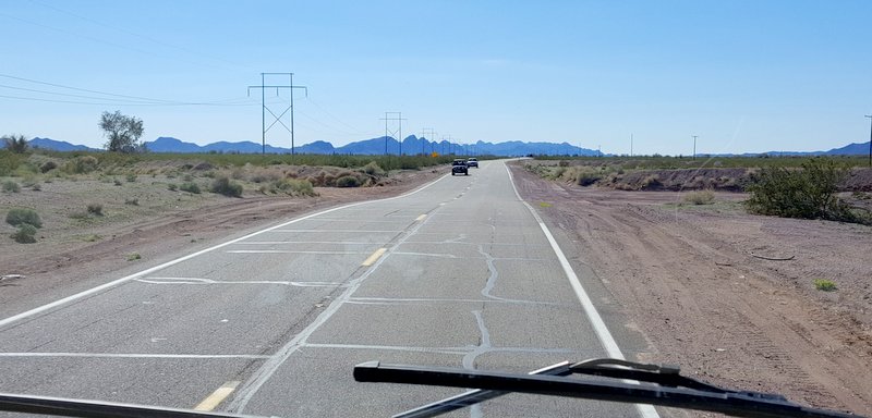
We have been living in the desert for a few weeks, and we are used to the barren fields of sand and cacti now. We are also used to the dips in the roads with signs warning not to enter when the roads are flooded. It's a little hard to imagine that much water around here! Those steep dips look like a little wrinkle in the road when you try taking a picture, but they feel like part of a roller coaster ride when you cross them at 65 mph in a motor home.
There has been enough rain lately that we see a hint of green beside the road as we made the drive south from Quartzsite, AZ to our next destination at Yuma, AZ.
After so much brown desert, we are pretty excited to see that the closer we get to Yuma, the more fields of green we see! That would include citrus trees that have been trimmed into curious-looking tree cubes.
We learned that Yuma is the "winter vegetable capitol of the world." As we drive the country roads, we are surrounded by fields of those veggies.
February is a major vegetable harvest month, and we see large groups of farm laborers in the field. They show up in individual cars, or some are transported by big white buses to the field. Those big buses also tow a trailer of port-a-potties to the field with them.
We see some machinery that helps with the harvesting process. Mostly it provides a platform for boxing the vegetables. The picking is done piece by piece and by hand. It looks like a back-breaking job to bend to the ground to cut off each head of cabbage, or each stalk of broccoli, or each head of cauliflower, or each bunch of celery, or each . . . well you get the idea.
We could sit and watch this process for hours. That must mean we are easily entertained. It's also because we have found a road-side factory tour on the farm.
After seeing so many fields of vegetables, Denisa was excited about buying these fresh veggies. But this produce is going straight onto 18-wheelers to packaging plants that transport them all over the United States. We heard that 3,000 trucks stacked high with fresh produce leave Yuma every day.
Those trucks are headed for processing plants with names like Dole and Green Giant. So the only option for fresh vegetables in the winter vegetable capitol of the world is to go to the farmer's market or the grocery store.
Yuma county provides 90% of the leafy vegetables eaten in this country from November to March. Check the lettuce in your refrigerator, because it was probably grown near us.
We haven't seen any spinach being harvested, but the fields of it are a deep beautiful green right now. If that was a crayon, it's color could be "spinach green."
They grow butter lettuce, iceberg, romaine, and other types of greens that we don't even recognize as we zip down the highway. The fields growing burgundy lettuce are really pretty, and a nice salad contrast against the bright green lettuce.
Actually, we aren't always zipping on the highway. We love driving through the country-side, where we can see the crops at slow speed.
Some of those roads are just dirt paths between the fields, and we've had to turn around more than once when we came to an impassible section.
All this green and bountiful food is compliments of water diverted from the Colorado River. Yuma gets around three inches of rain per year, so these crops wouldn't grow without the water that arrives via canals throughout the valley.
Owning water rights is important to land holders. It is interesting to see a cabbage field on one side of the road, and barren desert on the other side of the road. The difference between the two are the water rights. Out of that water comes beautiful heads of cabbage, ready to be picked.
Speaking of water, we are camped about 100 yards from that Colorado River. We chose Hidden Cove RV park for multiple reasons. We liked the location close to the river, and close to the West Wetlands Park.
We can ride our bikes or run to the park, as it is less than a quarter-mile away. There are biking and hiking trails there, as well as gardens, playgrounds, pond, etc. We saw that there were several century plants at the entry that are sending up large stalks to support their once-in-a-lifetime blooms.
The other reason we chose Hidden Cove was its acceptance of the Passport America rate this time of year. Among the 15 passport campgrounds listed in Yuma, most do not honor the half-price rate in January through March. We actually used Hidden Cove's very affordable weekly rate, that got even better when Denisa spotted a 50 dollar coupon for first-time visitors.
We've found that Yuma has some good bike trails, and we've ridden all over town. From the motor home's camp site we can ride all the way to the East Wetlands Park and beyond. We rode under the new Interstate 8 freeway, and can see ahead of us the old "Ocean to Ocean" bridge.

This steel structure was built in 1915, and was the final link to make a driveable passage from the Atlantic to the Pacific via Highway 80. That's the reason it's called the Ocean to Ocean bridge. During the 1930's, carloads of Oklahomans used this bridge to finish their journey west to start a new life away from the depression era drought in their home state. Across the bridge was the magical state of California with promised prosperity. But too many Okies were flooding into the state, and the Los Angeles Chief of Police sent officers to this bridge to screen the Okies and Arkies. They had to prove they had a job waiting for them, or a minimum of $50 in cash before they were allowed to cross the bridge in to California. Many of those that were turned back at this bridge stayed in Yuma, Arizona, and a large neighborhood nicknamed "Okie Town" sprang up in downtown. That was an interesting story for a couple of wandering Okies like us.

We're learning about agriculture and history in our new home. People that have lived here their entire lives are called "totally Yuman." We've also seen signs about keeping parks clean "for the good of Yuman-kind." We plan to be a little more Yuman by the end of our 9-day stay.
While we were camped in the desert outside Quartzsite, Arizona, we decided to take a road trip to the west. Ten miles down the road, we crossed the state border into California in the car. We passed through one of those agricultural inspection stations, and they didn't even ask if we had fruit on board. But we're guessing they might ask more questions when we drive the motor home across the border about a week from now.
The Colorado River is the dividing point between Arizona and California in this part of the state. We got a good view of the river, where we decided that it was flowing too fast to try paddling the kayak upstream and floating back. So today, we'll just view the Colorado River from the bank.
The water from the Colorado River is used for irrigation, and as we drove across the California country-side, we saw water canals criss-crossing the desert.
Instead of desert sand, there are beautiful green fields of vegetables as far as the eye can see. This crop of onions was divided by furrows that are flooded to water the plants. We had our windows rolled down, and we could smell the onions as we drove by.
Denisa thinks that rows of vegetables are as pretty as flower gardens. Each cabbage is formed in the middle of a rosette-shaped plant.
We thought that it looked like the cabbage was ready for harvest. Sure enough, there was a tractor-powered harvest platform parked at the edge of the field.
Crews walk behind, bending over to cut the cabbage from the plant. They lay each head on the platform, where more workers are folding boxes, and filling them with those fresh heads of cabbage.
We enjoyed our agricultural tour through the country-side, but our real destination was Cibola National Wildlife Refuge. The visitor center was closed, but it posted the number of birds residing in the park this season: 1,650 sandhill cranes; 2,850 Canada geese; 1,750 snow geese; 20 white-fronted geese; 5 burrowing owls; 15,000+ ducks. We think we found most of these birds on the little lake not far from the visitor center. They were packed together like their human counterparts--snow birds wintering in Arizona in RV parks.
Here is a close-up of a few of those 1,750 snow geese. They are a long ways from home, as they spend their summers north of the timberline in Canada and Alaska.
Among the 15,000 ducks here, we took a close-up of a couple of our favorites.
Something spooked a flock of mallards, and it was neat to watch and hear as hundreds of them took to the air at once.
We drove the loop trail, and hiked the nature trail. The wildlife refuge had set up man-made homes to entice the burrowing owls to nest here. This guy was coming out of his new condo to check out the traffic.
Of the 5 burrowing owls reported at the visitor center, we saw two of them. This second bird had his back to us, but could still keep an eye on our progress by rotating his head.
Owls can turn their heads all the way around backwards. That made it easy for him to give us that squinty-eyed-I'm-watching-you glare.
Instead of worrying about us, the owls should have been more concerned about this coyote lying on the ridge not far away.
He rose to his feet to let us know that he was watching us as well. It's always fun to spot some wildlife in a wildlife preserve!
As we drove back towards home, we passed more of the beautifully aligned vegetable fields that fascinate us. But we also saw a more familiar crop--alfalfa. We saw it being cut, and baled, and bales being automatically stacked with new-fangled hay-hauling machines. Mark worked as a hay-hauler while we were dating, and he developed some good muscles from stacking those bales by hand. Too bad this generation of farm laborers will miss out on that.
We haven't seen any cattle in the desert, so we were wondering where all these alfalfa bales were heading. Mark read that most will be shipped to China, Japan, and the Middle East. Those countries don't have enough water to grow alfalfa for their beef and dairy herds, so they must pay the hefty freight to deliver it half-way around the world! Mark also read that Saudi Arabia is buying up these fields in the desert Southwest of the U.S., especially those with water rights to receive that precious water through the canal system.
We start and finish this blog with pictures of the mighty Colorado River. It has turned parts of this desert into an oasis of green that makes for a beautiful road trip, as we cross the river back into Arizona. Another educational part of this road trip to California was seeing the price of fuel across the state line. The gas station just a few miles down the road into California priced gasoline at 90 cents more per gallon. Before we cross the state line in the motor home, you can be sure that we'll be filling up that 100-gallon diesel tank in Arizona.
We were back to the motor home in time for sunset over the desert at Dome Rock BLM campground. It has been a good boondocking stay, but we're ready for some water and electric hook-ups as we head down the road to new adventures.
Another educational part of this road trip to California was seeing the price of fuel across the state line. The gas station just a few miles down the road into California priced gasoline at 90 cents more per gallon. Before we cross the state line in the motor home, you can be sure that we'll be filling up that 100-gallon diesel tank in Arizona.
We were back to the motor home in time for sunset over the desert at Dome Rock BLM campground. It has been a good boondocking stay, but we're ready for some water and electric hook-ups as we head down the road to new adventures.
We have been eyeing the tallest peak in the Dome Rock camping area ever since we parked the motor home outside of Quarzsite, Arizona, several days ago. We thought it would be nice to go on a hike straight from our doorstep. So we grabbed several tangerines, and headed towards the tallest peak in the picture below.
It was a mile's walk to get to the foot of the mountain. We knew the area had gotten rain recently, and it looks like the desert floor has been carpeted with tiny green buds. It might be a good year for wildflowers near Quartzsite in a few weeks.
There were even a few little purple wildflowers bravely poking their blossoms out in February.
There are ATV roads that wind through the desert, and we followed one of those roads as long as possible.
Then we had to hike off-road as the mountain got too steep for the motorized vehicles. Even though it isn't visible in the picture, we could see our motor home only as a dot from that height.
On this steep mountain-side, we found a barrel cactus with curiously red needles.
But our best find of the day was this young bighorn sheep that was right in front of us when we topped the next ridge! His white rump is the most visible part among the brown rocky mountain. He looked very surprised to see two-legged creatures up on his mountain.
When we left on this "short" hike, we didn't take the backpack, or the binoculars, or more importantly--the good camera. So the only pictures we have are those taken with a phone. The phone takes a good landscape picture, but it can't get important details.
The detail in the picture above is the same desert bighorn sheep, barely staying ahead of us as we hiked higher. We were so sad to miss a good sharp picture of this guy with his short curl of horns.
So we were super sad to not have a good camera when we noticed that an older and bigger horned sheep was a little higher on the mountain. We were spell-bound at we watched this magnificent creature climb effortlessly on the side of that steep mountainside. The fuzzy picture below is our best effort to share that completely curved set of horns on the older ram.
When he gave us the classic side-pose from the ridge of the mountain, we were really wishing we had brought the camera. But we were enjoying the scene before us too. In the upper left hand corner, you can barely see the ram's head sticking up over the ridge, just to put some scale to the side of the mountain.
Our best fuzzy picture of our National-Geographic-posed desert bighorn ram is below. You can be sure that we won't be forgetting our camera on any future hikes!
The sheep out-distanced us as our terrain got rockier and steeper. Denisa often says that Mark can climb like a mountain goat, but today he had his wife slowing him down. But we both did make it to the top. That's Denisa perched on the very top, with the valley far below her in the background.
Mark is holding one of those tangerines we grabbed when we left on this hike. It was a nice snack at the top, but we should have grabbed the camera instead!
The problem with making it to the summit, is now we have to make the tough climb back down. The only thing harder than climbing up, is going down over those loose rocks. Now we are glad we don't have a camera in our hand as we are sliding and crab-crawling down. It wasn't pretty, and it was a long haul down to those little roads in the valley that will take us back to the motor home.
It was good to see our home on the horizon as our tired legs finished this loop hike. We had left on a "short hike" several hours and several miles before. More than ever, we are sure that this is a great camping spot!
We were invited to another dance that evening, but we were too tired after going on our mountain hike. So we limped our way to another Quartzsite institution--Silly Al's--for pizza.
We walked in the door of the restaurant at 7:00 p.m., and were seated at a table right in front of the dance floor just as the live band started. Mark thought it was interesting that Denisa's tired legs were suddenly feeling good enough to dance every song until our pizza came out of the oven. You won't be surprised to know that we forgot the camera (again), so we don't have pictures of our Reuben pizza either. There are days like that!