Monday, August 30, 2021

How do Two Wanderers Celebrate a 40th Anniversary?

Because we get to see and do so many neat things on a daily basis, how do two wanderers like us find something special to celebrate a special occasion? That is the question we have been asking ourselves this year, as we got closer and closer to our 40th wedding anniversary. We were waiting to see where our wanderings would take us, and we finally made the decision to head to the Oregon coast.

From traveling here four years ago, Denisa had very pleasant memories of the beaches at Bandon, Oregon. So because Mark is a wonderful husband, he drove his wife in the motor home all the way to Bandon for our 40th wedding anniversary.

Actually, it was a very good practical decision as well. As the smoke was getting worse in central Oregon, it was also heating up there. We were seeing forecast highs over 100 degrees on our intended travel itinerary in the center of the state. On the other hand, the coast was smoke-free with highs in the 60s and 70s. So it seemed a romantic no-brainer to head across the state to the coast. The morning of our anniversary found us driving through the last of the Oregon forests on a narrow winding road straight west to the ocean.

We arrived in Bandon in time to check into our site at Robbin's Nest RV, and still get to the beach. We had fish and chips at a little cafe on the water, and then we hit the beaches with their wonderful display of towering rocks called sea stacks.

Last time we camped at Bullard Beach State Park, but on such short notice they were full. But we made the drive out to the state park to visit the Coquille River Lighthouse.

It was really windy at this driftwood-lined beach at the state park. The wind made it "keep-your-hands-in-your-pockets" cold as we were beach-combing. That certainly is a switch from 100 degrees in central Oregon!

As we followed this beach, we found many clear gelatinous clumps shimmering in the sand. When we googled "clear jelly stuff on beach" we got several possibilities. So we'll just include the interesting picture and let your imagination race with what it could be.

We have found that Oregon beaches have few sea shells. But Denisa managed to find a crab shell and some pretty beach stones to make a "40" in the sand to commemorate our 40th anniversary.

We had planned to eat another meal on the beach this evening, but we found that the little cafes in Bandon close early on a windy Sunday. So we opted for ice cream instead, at the yummy Face Rock Creamery.  This delicious shop is named after one of the rocks we saw today at the beach. Of all the uniquely-shaped sea stacks on the Bandon Beach, this one that looks like a tilted face looking to the sky is probably the most famous. Can you see the face of Face Rock?

When people find out that we have been traveling for over six years, they often ask where our favorite place has been. While that can't seem to be answered with only one place, Denisa's short list will always include the Oregon coast. We love it that this state has kept all the shore line public, and it is accessible to everyone. 

One of Denisa's anniversary wishes was to be at Bandon beach during low tide. When we checked the tide schedule, we found that would be at 7 p.m. So of course, Mark got her to the beach on time. Low tide means that those big sea stacks that are normally in the water, are now high and dry.

The incoming sea waves have eroded caves in this large sea stack.  During low tide we can walk into these caves for cool pictures. Can you see Mark inside the cave in the first opening?

Some of the openings into the sea caves are tall slits that make for interesting silhouettes.

Normally the water would be flowing through this cave.

As the water recedes, we can see the base of these big sea stacks that are usually covered with water.

That lets us see the sea creatures that live on the base of the rocks. We love the orange and purple sea stars!

For the best views, one must follow the tide out for a quick view, and then be ready to run to higher ground when a big wave comes in.

It was a great evening of finding green anemones with their slippery fingers . . .

and uniquely striped mussels clinging to the damp rocks.


Some people were going on a horseback ride on the beach,

but we rather preferred our stroll on the beach after they left with only horse shoe prints in the sand.

The sun was sinking lower in the sky, making dark silhouettes toward the water, 

and lighting up the unique-shaped rocks further from the water.

We took a couple more pictures of Face Rock, looking up towards the setting sun . ..


To stretch this 40th anniversary even further, we took the time to head to another beach closer to our RV park for another sunset view.

The wind has calmed, and it was a tranquil picture here at our new beach.

This is a more secluded beach that requires a climb up through the dunes and grass. 

That seclusion also allowed us to surprise this young fawn in the grass.

We enjoyed another long walk on the beach as the setting sun lengthened our shadows. Forty years ago, our wedding invitation read: "This day I will marry my best friend, the one I laugh with, pray for, dream with . . . love." It's been forty years of laughter, with many prayers answered, and dreams that have come true. So that's the way two wanderers celebrate a 40th Anniversary!


Sunday, August 29, 2021

Crater Lake National Park - another of God's wonders

Wow! We have to start by saying that we have wandered into another of God's wonders today when we  see the brilliant blue color of Crater Lake! This is a travel day as we are heading further west, but we're taking the entire day to enjoy this lake. Crater Lake was formed when a massive volcanic eruption left a deep basin in the place where Mount Mazama once stood. Because it is sealed off from rivers and streams, it was filled only with rain and snow, giving it unmatched clarity.

We dropped the motor home off in a parking area beside the highway, and then drove the pickup to the north entrance of this busy national park. We got our first views of the day on the north shore of Crater Lake at 11 a.m. Then we started a clock-wise circle on the Rim Road, stopping at the pull-outs to admire the different views of the lake.

Very early in our circular drive, we came to the Cleetwood Cove Trail, the only place that visitors can "legally" get down to the water's edge. Before starting this one-mile hike that descends into the caldera, the ranger gives each person the "be sure you can hike back up before you make the decision to hike down" speech. The trail does descend quickly as the switchbacks start right away.

But the descent is gentle, and most of the trail is shaded until you get very close to the water. You can see Mark several switchbacks lower on the trail, with that beautiful blue water behind him.

Crater Lake is the deepest lake in the United States, and one of the deepest in the world. A narrow ledge near the shore is a teal green color because that water is shallow for a few feet. Then it drops off into remarkably deeper (1,949 feet) water immediately.

As we peered into the water, we could see the ledge and then the bottomless abyss of Crater Lake.

When we first got to the water's edge, we were a little disappointed with the crowds. It seemed like there were people on every rock and dock. So we kept walking on the trail along the water.

We finally found our own rock near the end, for our water-level view of Crater Lake.

We took off our hiking boots to enjoy a cool foot soaking. The water is so clear that you can't even see the water line on our legs as we look down at our toes. The ranger at the top bragged that this water is the purest in the United States and they intend to keep it that way. So visitors are allowed to swim--but no water shoes, flippers, or anything plastic can be on your body when you do.

Dressed like we are, we hadn't intended to swim. But it was a little warm, and the cool lake water felt good to our feet. Almost everyone around us was swimming, and with a little encouragement Denisa sat down in the water.

Before you know it, she was all the way in the water for a swim. It was take-your-breath-away-60-degree water, but it felt really good after that first dive in. 

Being a little damp will make the hike back out of here much cooler!

Our spot on the rocks made for a great place to watch people jumping from the 30-foot rock platform. Denisa was taking a picture of Mark taking a picture of this guy making a fancy backward dive.

That's about the time that Mark decided he was going for a dive too. That's him on the top of the rock, contemplating the 30-foot dive.

He didn't think about it for long, before he made the big jump.

From watching Olympic diving this summer, Denisa is thinking this dive will get good scores for straight body alignment, and Mark made only a small splash when he entered the water.

When you hit the water you get the full effect of that cold water and how deep you go down into it. As Mark popped back up to the surface, he got a round of applause from the spectators.

As he climbed out of the water beside the people that had just jumped, we decided that he was probably twice as old as most of the other divers today.

When Denisa met him back up at the top, she took one more picture of him by the jump-off cliff. It's a long ways down!

This is the bright blue view looking down from the diving platform.

After making the up-hill hike back to the crater rim, we continued our 32-mile circle around the lake. There are more than 30 pull-outs, and we stopped at most of them.

After being on the water's edge, now we are way above the lake.

Many times the rim high above the water has a steep drop off.

We took the one-mile spur road out to the Cloudcap Overlook--the highest paved road in Oregon. Then we made the hike out to the highest point above the lake to get a panorama of this incredibly blue water. 

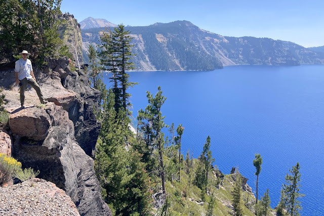
The national park newspaper listed "must-see" stops to make. That would include the Pumice Castle Overlook. The orange rock has eroded into the shape of a medieval castle, and is visible on the canyon wall across from Mark.

Another "must see" is the "Phantom Ship." It may look like a small sailboat from this distance, but it's actually an island that is as tall as a 16-story building.

Besides the drive-up view of phantom ship at that last overlook, we found a hike-up view on the Sun Notch Trail. The trail took us through a forest of tall trees . . .

to the closest view of "Phantom Ship." 

This interesting rock formation does look a little ghostly from land. We're also noticing that the smoke from the nearby forest fires has crept into the Crater Lake area this afternoon. By 3:30 we could barely see the outline of the rock walls on the other side of the lake.

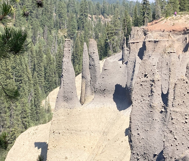
We are pretty thorough when we explore a national park, so we also took the 6-mile spur road to see the Pinnacles Overlook. It's a little hard to understand how tall these spires are until you focus in on the tiny pink dot in the upper right hand corner. That dot is Denisa.

You can find the pink dot in the upper left hand corner in the following picture. The scientific name for these spires is "fossil fumaroles" and the national park paper explains that "they are the result of volcanic gases that rose up through a cooling ash deposit from the eruption that formed Crater Lake."

We call it another of God's wonders that we get to wander above.

We stopped in at the Rim Village, and found a wonderfully shaded table to eat our picnic dinner. Even though we didn't take a picture of our picnic, Denisa was photographing the birds that showed up to check for leftovers when we were leaving. This Stellar Jay was a little sad that we cleaned up so well.

The Rim Village is the part of the lake you first explore when you enter from the more popular south entrance of the national park. Most of the year this is the only entrance open because snow closes the Rim Drive and the north entrance during the winter. When we visited here in April, 2017, we entered on this south entrance with 15-foot snow drifts in the parking lot. On that visit, we took this picture of Denisa standing in the snow that was still deep enough that we sometimes sunk up past our knees when we tried to hike.

It's taken from a very similar place, but today's picture has a very different look in August, 2021. We must say that we like the looks of the snow cover better than the smoke cover.

The island that can be seen in both of the previous two pictures is called Wizard Island. It's actually a 6,940-foot cinder cone that rises out of Crater Lake. Since Crater Lake was formed when the volcano of Mount Mazama erupted, and Wizard Island was formed from a volcano, a sign at the rim explains that this is a "volcano within a volcano."

It was almost 6:00 by the time we made the full circle back to Merriam Point where we started this morning. Just as quickly as the smoke arrived this afternoon, it has now receded leaving us with just a brown smudge on the horizon. That far shore is about six miles away, so our visibility is pretty good this evening.

Merriam Point has some twisted old trees with exposed roots hanging onto the side of the caldera. It also has one of the best phone signals in this rather remote park, so Mark made his nightly phone call from here.

We were glad we got to spend the entire day at Crater Lake National Park, and it was a great day! Now we must drive the pickup back to where we left the motor home on the side of the highway, and continue west this evening. We didn't plan to spend the night here because this has been an area plagued with wild fires this summer.

As we traveled west along Highway 237, we crossed the 23,000 acres of burnt trees where the firefighters have been battling the Jack Fire that started on July 5.

We found big machinery and logging equipment along this section, as well as stacks of trimmed burned logs. We found out later that these trees are still good for lumber if they are harvested quickly.

It must be quitting time at the forest fires, because we met 11 different fire trucks on this stretch of the highway.

Outside the little town of Glade, Oregon, we found the Fireman's Campground. It stretched for a half-mile, filled with every form of movable housing available. We also saw large gathering tents, kitchen trucks for food preparation, and 18-wheeler-sized portable restroom facilities.

Some of the luckier firefighters were staying in RVs, and many more were sleeping in tents.

Our destination is just a little further down the highway at the city of Roseburg, Oregon. We passed several nice Forest Service campgrounds, but we didn't feel comfortable camping so close to a forest fire. So we drove on to a more populated area. We had planned to stay at the county fairgrounds in Roseburg, but then found out it was full because of the county fair this weekend. Then we considered the Love's Travel Plaza along the highway. But after filling up with diesel, we found that 18-wheelers had already filled every single space. So at the end of this particularly beautiful day, we ended up in a grocery store parking lot in Roseburg. But we slept well, remembering all of God's wonders we saw today at Crater Lake National Park.