Saturday, August 31, 2019

Exploring the Waters of Invermere--Floating the Columbia River

This is part two of a blog that got too long yesterday. So this is a continuation of "Exploring the waters of Invermere," the little town just south of where we are camped.

Yesterday we wrote about all the water sources we had explored around the town of Invermere. But we hadn't yet been on the most important water--the Columbia River. It took some imagination, but we finally figured out a way to kayak the section of the Columbia River from Invermere to Radium Hot Springs.

Floating down a river means that we need two vehicles--one at the entry point and one at the exit point on the river. On the day we left this area, we used the motor home as one of our river shuttle vehicles. We dropped the car off at a take-out spot on a forest service road west of Radium Hot Springs. The road was rough gravel with lots of pot holes, so Denisa was planning to walk the mile back to town. But instead, she got a ride back to where Mark was waiting in the motor home. Then we drove the motor home to the put-in spot in Invermere where Mark had gotten permission to park.

Then we inflated the kayak and started our three-hour float at the north end of Lake Windermere. Remember, this is the lake that will become the world's longest skating trail once it ices over this winter.

The water is perfectly clear here, and we can see the water grasses beneath the surface as we take off.

The clear water makes for great fishing conditions for the birds in this wide section of the Columbia River wetlands.

We immediately started seeing raptors sitting in the tall trees beside the river, waiting for lunch to swim by. We saw bald eagles,

and an osprey sitting like an angel on the top of a Christmas tree.

With that clear water and calm winds, it was a perfect day to be on the river.

We also found this family of ducks that didn't mind hanging out near our boat this morning.

Mom and Dad were showing the ducklings the bottoms-up method for finding breakfast on the river as we floated by.

Denisa is always looking for wildflowers, and she wasn't disappointed even on the water. An entire mat of interwoven flowers was floating near the bank.

That mat is made up of tiny 5-petal daisy-like flowers. The Columbia River doesn't disappoint even a flower-lover!

The current on the river was minimal while we were in the wide wetland section close to Invermere. But then the river narrowed, and we saw an increase in the current when a smaller river came in from the left. We also noticed that side river was cloudy as it contained a lot of glacial silt. We waited for the additional silt to settle so we could get our clear Columbia water back.

And we waited some more. Miles later, and the clear water that we started with looks more like the glacial lakes we've been paddling.

It was a calm float that required some paddling to get us all the way to Radium in a timely manner. We were entertained by changing scenery, like these white cliffs.

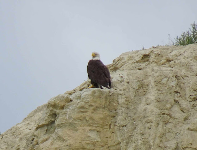
But wait, what's that at the top of that cliff? After we saw a golf swing, we realized that was a tee box on one of the many golf courses we've driven by in this valley. But wait (again), what's that odd-shaped knob just to the left of the tee box?

When we floated by, we saw that "knob" was a bald eagle, sitting just beyond the tee box. Because he was sitting just below the cliff top, those golfers had no idea he was so close.

As we floated past the last curve before our take-out spot near Radium Hot Springs, we counted this as a great kayak trip. The Columbia River is the longest river in North America that empties into the Pacific Ocean, and we got to see it very close to its beginning.

We got the kayak packed up in the car, then drove down the highway to where we left the motor home this morning in Invermere. We have wandered God's watery wonders here! We have successfully explored the lakes, the rivers, and the wetlands around Invermere, British Columbia. Now it's time to fire up the motor home (aka the river shuttle vehicle) and head down the road to our next destination.

Thursday, August 29, 2019

Exploring the Waters of Invermere, British Columbia

During this summer season, it's fun to explore the water around each of our new home towns. Just 16 kilometers down the highway from Radium Hot Springs is the nice little town of Invermere, and we spent the day checking out its water. The town is built around the biggest lake in the area--Lake Windermere. The beach there was full of Canadians trying to get tans in this really short summer season.

This lake was too big and too crowded for our preferred kayak trip. But it's interesting to think about what this place will look like in a few months. A billboard at the beach describes the winter view when Lake Windermere freezes. Then the lake is known as the "Whiteway" and becomes the world's longest skating trail.

The woman at the Invermere visitor center thought that Lillian Lake might be the perfect place for us to go kayaking.

It's west of town, and on a paved road so it's easy to get to the lake. Maybe a little too easy, as it was pretty busy even during the week. But once we got away from the swimming beach, we found some of our favorite birds showing off for us in the water.

For some reason loons let us get closer than most water birds. We could even see the water droplets on the head of this bird that just came up out of the water very close to our kayak.

Even though it was perfectly clear, the waters of Lake Lillian were pea green in color.

Because it was perfectly clear, we could see our friendly loon under the water when he dove again. Normally when a bird dives, it's a mystery where they will come up again. But for the first time, today we could follow his movement under the water. Interesting!

For a busy lake, we had more wildlife sightings than usual. This duck was sunning on a log on the edge of the water, carrying on a conversation with his neighbor, the turtle.

We had just commented that in all of our time on the water in Canada, we had never seen a turtle. We didn't know if they didn't like the cold weather, or the glacial silt in most of the mountain lakes. We found out today it was really because they were all hanging out at Lillian Lake.

This guy had a bright red-orange belly that was reflected in the water below.

Denisa must have really been missing her turtles, as she kept taking pictures of them today. But these two turtles telling secrets on the log were just begging for a photo.

A series of mountain bike trails can be found across the road from the lake, but we opted instead for a hike. Guess what? We found that water is also included in our hike today at the Wilmer Wetlands. It started with a hike to the top of a bluff overlooking the ponds and creeks that make up this section of the Columbia wetlands. You can barely see Denisa on the bluff on the left side of the picture, looking out over the water. The wind was perfectly still today, allowing for a reflection of the puffy white clouds on the water around us.

This is actually a wildlife refuge, and we think that this would be a great place for a moose to hang out.

But the only things we found taking refuge here are birds, and they are keeping their distance. We got this long distance picture of an osprey surveying the wetlands from the top of a tree.

But we are loving the views as we hike in the hills. In fact, we're feeling the love here in the Wilmer Wetlands and the surrounding Rocky Mountains.

Does anyone else see the love?

It really was a nice place for an unusual hike . . . until Mark thought it would be a good idea to scramble down to a trail way down near the water's edge.

The only problem with that low trail is that in order to get back to the car, we had to climb back up that hill that had somehow grown taller.

Since we are writing about water, we should include that we have been wanting to kayak the Columbia River that flows from Invermere to Radium Hot Springs. But this blog has already gotten too long, so we'll save that story for tomorrow.

Wednesday, August 28, 2019

Kootenay National Park

Sunday after church we left our campground in Golden, British Columbia, and headed further south along highway 95. We are traveling in a valley beside the Columbia River with mountains on both side of us. We are headed to our new camping spot at a golf course in the tiny town of Edgewater. It's a beautiful place with golf fairways all around us, and wildlife that comes to visit.

A tree near one of the fairways is dropping its apples, and Mark spotted this buck with one in his mouth.

The golf course has seven full-hook-up sites, and we have one of those sites for the next four nights. After spending the last month in national park camp sites or boondocking in the icefield, we have a big pile of dirty clothes to tackle during this stay. Our next door neighbor is leaving in the morning, so he gave us the rest of his tickets to the Radium Hot Springs just down the road. So we thanked him profusely and headed for a soak in the mineral hot springs on this chilly evening. We didn't take the camera to the pool, as we assumed we would take pictures later. But we did get this picture of the "cool pool" that we also enjoyed.

We are loving our golf course camping spot, but we would have really preferred to be in the Village of Radium Hot Springs. But all of their campgrounds were booked many months ago when we were making reservations. Radium Hot Springs is the gateway city to Kootenay National Park, and we want to do several hikes there. We have already visited the east side of this park when we were staying in Lake Louise Village, but now we get to see the west entrance of Kootenay and its impressive Sinclair Canyon.

Through these tall canyon walls is carved a winding two-lane highway. Since this is a major thorough-fare, everything from motor homes to 18-wheelers roar through this narrow canyon right beside hikers like us. In fact, it was difficult to get a picture of the canyon without a vehicle in it.

One day we hiked the Juniper Sinclair Canyon Trail that took us to the very top of those canyon walls.

From the trail, we could see that there is a waterfall under the ledge that supports the highway through that narrow canyon.

It was hard to get close to that waterfall, but we tried. We walked all the way down to the bottom of the falls, but it was hidden around the corner from us.

After being down below the highway, we once again hiked to the top of the other canyon wall on the Redstreak Trail. That gave us views of the mountains around us--and the fenced viewpoint we had just left on top of the facing canyon wall.

We have heard about all the mountain sheep that wander around the Village of Radium Hot Springs, but we hadn't seen any. When we hiked up a ridge on this trail, we finally caught a glimpse of those elusive sheep.

The three ewes don't sport the massive horns that we've seen on the rams. But they were friendly, and seemed to be as interested in us as we were in them.


It was a great hiking loop with high mountain views and low waterfall views and a little wildlife too!

After driving deeper into Kootenay National Park, we stopped to see Olive Lake, which is about the color of a--well-- olive.

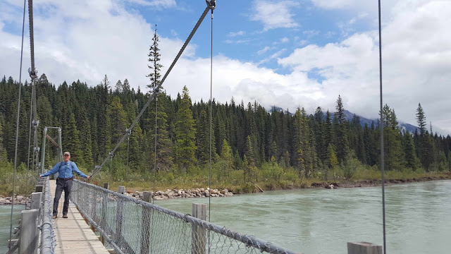
We could see some blue in the sky as we started another hike--a four and a half mile loop to Dog Lake. But first we had to cross the suspension bridge over Kootenay River.

It's a great hike through the trees with some elevation gain. But when we got to Dog Lake, our blue sky was completely covered with clouds that had an angry gray color to them.

Sure enough, it started raining shortly after we left the lake. That meant that we hiked the last couple miles in a steady rain on a trail that began to look more like a river. Denisa had her rain coat in her backpack, but Mark had taken his out to dry after his shower at Wapta Falls a couple days ago. So we will compare the picture we took earlier in the day when Mark was dry and looking forward to his hike . . .

to Mark on the same bridge--now soaked to the skin at the end of the hike.

It continued to rain the rest of the day, so we had more time to stay inside the motor home and work on that laundry! But we also found out that this big rain caused flooding to the water source for the Radium Hot Springs. When we tried to make a return visit for more soaking (and pictures) in the hot mineral pool, it was closed. In fact, the entire Village of Radium Hot Springs has to boil its water, and the hot springs was "closed indefinitely" when we left the area. (P.S. We made the drive to the Fairmont Hot Springs 23 miles south, and found it is a similar sized facility. But instead of the $7 fee per person at Radium, the Fairmont charges $23 per person! We decided we didn't need to visit the hot springs after all!)