
We didn't get a picture, but a bald eagle swooped from the sky and landed on a branch beside the highway as we drove past. All three of us got to see him up close, and we realized that it was going to be a special day.

Denisa was taking pictures of Blake hanging out of the car window while he was taking pictures of leaves.

Everyone in the car yelled, "Wow!" when we came to an opening that gave us a glimpse of the mountain-side exploding into red, orange, and yellow tones.

The highest point in West Virginia is Spruce Knob Mountain. So we started at the top with this view. We could actually drive on a single lane road to within a quarter mile of the peak. The walk to the summit was our first hike of the day.

At 4,863 feet, it is not only the tallest point in West Virginia, it is also the highest peak in the Allegheny Mountains. It was chilly up at that altitude, so we were still wearing our jackets at 11:00.

On the way back down the narrow mountain road, Blake has already ran out of photo storage on his telephone.

Mark is an amazing driver! He can drive down steep grades on narrow roads that have no lines or shoulders, and still take pictures out his open window. Check off Spruce Knob as our first West Virginia Wonder.

Our second destination was 21 miles away, but it took 39 minutes to get there. The mountain roads in West Virginia are for savoring, not for driving fast. We arrived at the parking lot of Seneca Rocks around noon, and got our first view of our next peak to conquer.

We took the 3.4 mile hike to the top of Seneca Rocks. There is a 900 foot elevation gain within one mile, so it felt like we were on a stair-master most of the way.

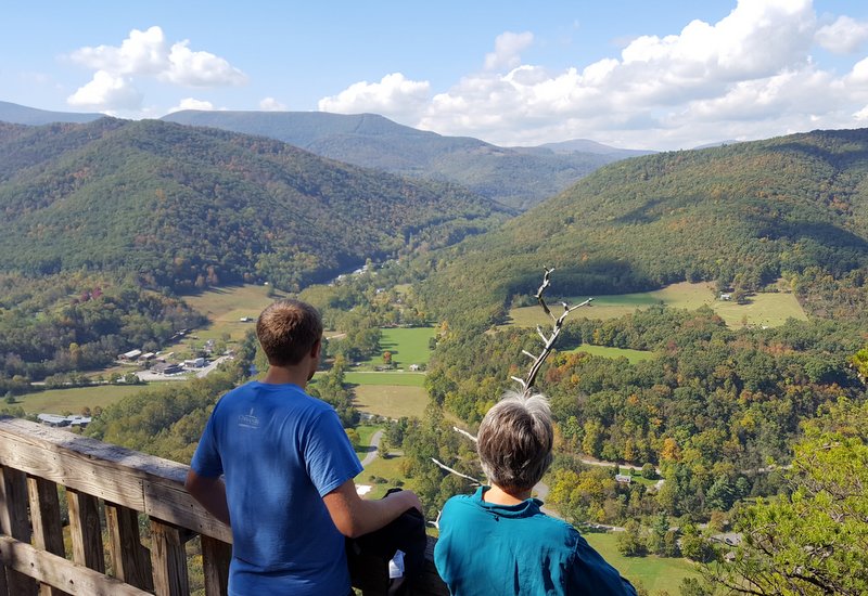
The official end of the hike is to see the view from the wooden platform, complete with a guard rail for safety. We could see the valley far below.
But after that wooden platform is a warning sign that reminds hikers that they are responsible for their own safety if they choose to go higher onto the rock ridge. That sounds like an invitation to someone like Mark, and you won't see any of those pesky guard rails here.

Denisa remembers a song with words that vow "whither thou goest, I will go. . ." so she headed out on that narrow rock fin as well.

Blake hadn't flown all the way from Oklahoma to watch his parents climb on rocks. So against his best judgement, he joined us on the rocks.

It was a breath-taking view seated on the rock fins of Seneca Rocks.

Because it is a narrow rock ridge at the top, we could also see down into the valley on both sides of the mountain.

We passed the rest of the hikers that were taking responsibility for their own safety on the rocks. But Blake and Denisa have enough sense to stop when the fin got narrower and the footing got more sketchy.

Mark obviously doesn't have that much sense. He continued on the rocky ledge to get views of the other fin across the saddle of the mountain.

He also took this picture straight down the rocky edge to the tree tops far below.

It was only after he was taking pictures of the adjoining rock peak that he realized that there were rock climbers rappelling down that vertical rock ledge.

A zoomed-in picture shows a guy in a blue shirt at the front top of the peak holding on to the rope. At the bottom left corner, you can see a blurry rock climber in white making his way down the vertical rock face.

So we have now found someone that has less sense than Mark when it comes to scrambling on a rocky summit. After we finally got Mark off the rocks, we headed back down the mountain. We found the trip downhill was much easier. Now we know why everyone coming down was smiling so big.

We had to get all the way to the bottom and across the bridge before we could once again see the top of Seneca Rocks. We had just climbed to the wooden platform in the trees on the far left hand side of the picture. Then, with Mark's encouragement we moved on up the rock face of that peak on the left side.

The sun was lighting up the rock face of the fin on the left. From this angle it is easier to envision where Mark traversed about half-way across the rock face. From there he took the pictures of the rock-climbers that were climbing the vertical rocks on the right side of the saddle.

Using our other camera, we could see that there were now three crazy climbers at the top.

Now we had conquered Seneca Rocks--check mark number two for the day by 2:00! Our next destination was Black Water Falls State Park. As we headed north on the winding mountain roads, we saw that the fall foliage continued to get more and more spectacular.

When we drove through an area called Canaan Valley, we were totally blown away by the stunning leaves.

We had read that this high mountain area of West Virginia generally is at peak fall foliage by October 1st. But with the warm temperatures that we have enjoyed all over the east, it looks like they are also two weeks behind in their normal fall foliage schedule. That means that we arrived with their fall foliage at its peak!

We found out that the locals don't pronounce this valley name like we have always heard this biblical destination. Instead, a local would say something like "Kuh-nane." The most said word in our car, however, was "Wow!"

We have always seen postcard pictures of mountains filled with red, orange, and yellow fall foliage. Now we can say that we have lived in the postcard ourselves. Each time Mark stopped the car, Denisa and Blake would jump out to take pictures. Mark thought it was funny to take a picture of us enamored with those beautiful leaves.

The GPS said it was 34 miles and should take 47 minutes between our stop at Seneca Rocks and our third destination of Black Water Falls. But we took a lot longer than that, with many stops and detours to follow a line of pretty trees.

When we finally arrived at Black Water Falls State Park at 3:30, we found that we weren't alone. Most of the parking spots were taken, but Mark squeezed into this one under a line of trees. It was beautiful to see a mixture of red, orange, green, and yellow leaves together to showcase all the colors that God made leaves.

The hike to the falls was all downhill, but not long. That means that the view points were crowded on this beautiful-weather weekend. But we still managed to snap a nice picture of the falls.

Just like many of the eastern states, Virginia has suffered through a drought this summer. There was considerably less water going over the falls today than we had seen in the state park brochure picture.
We can now put a check-mark beside the third of His wonders on Blake's list.

We also took the loop drive through the state park, and found more stunning trees.

It is 4:30 by this time, and we are over two hours from home. We made a quick trip into the tiny town of Thomas, West Virginia, to catch the afternoon local music scene at the Purple Fiddle. But when the musicians took a break, we realized that we still had enough daylight to perhaps make it to our fourth and final natural wonder. That is, if the beauty of the local trees doesn't slow us down too much. Even though we have experienced almost no wind in our travels in the east, we did see evidence that the wind does blow. This small group of windmills was nicely decorated with fall trees as well.

We set the GPS for Dolly Sods Wilderness Area--another 24 miles and a 47 minute drive. This drive took so long because the last 7 miles were on a one-lane dirt road. We filled the car with gas for the second time today, and headed out to the wilderness. We arrived at 5:50, with enough daylight to take a hike down the Bear Rocks Trail.

Dolly Sods is unique in that it is a high-mountain plateau in the Monongahela National Forest. That last sentence uses a lot of words that made no sense to us a week ago.

But since then we have learned that Dolly was named for the family that first settled here--the Dahles. Sods is another name for a high grassy plateau within a mountain range. The Monongahela National Forest is part of the Allegheny Mountains. But what makes this place so unique is that it is the highest plateau east of the Mississippi River.

Also, its flora looks and feels more like Canada than West Virginia. It was particularly beautiful this weekend, with the bushes decked out in a rich shade of red. Later we found out that these are blueberry and huckleberry bushes. In mid-July, Dolly Sods is famous for its abundant berry crops. Perhaps we will have to visit again in the summer!

We walked about a mile down the trail before the setting sun reminded us we needed to head back towards our car before dark.

That setting sun was flooding the Bear Rocks trail with golden light, and casting some long shadows of photographer Mark.

We had seen people with big cameras on tri-pods when we first arrived at Dolly Sods. Denisa just had to see what they were looking at on the other side of the mountain. So we headed through waist-high bushes and boulder-hopped to the edge of the plateau.

As Mark and Blake rested on the big white rocks that punctuate the plateau of the sods, we were rewarded with a view across the Allegheny Mountain Valley.

We can now put a check mark beside the fourth of God's wonders of the day--Dolly Sods.

The sun was setting over Dolly Sods at 6:20 when we started down the one-lane dirt road back to the highway. It was nice to know that no one would be crazy enough to be traveling that road in the opposite direction at that time of the day.

As we headed back towards the motor home, we still had a two-hour trip ahead of us. Mark drove most of the return trip in the dark. By the time we reached the motor home, we had traveled 320 miles. It was 8:30 p.m., over 12 hours since we left on our West Virginia adventure at 8:15 a.m. We had hiked eight miles, and we were blessed with another day with Blake seeing four of God's wonders in West Virginia. What a great day!

Looks like all had a great time in WV...
ReplyDelete