
The picture below is why she should be worried. We could see the rusty holes where metal rails used to be installed along many of the rock ledges we would hike this day.
It looks like Mark's parents are going to have to come along with us to supervise their child, because Denisa obviously is not doing a very good job of it. We are looking out over the Petit Jean Valley--where we had hiked several days before.

We stopped by the visitor's center, and the staff there described some of the hikes in the park. We were glad that we followed their advice to try the Benefield Loop trails. The Benefield family lived on this mountain many years ago, and they had a grand view of the valley far below.

They would have to teach their toddlers very early about not wandering off, as some of the drops off the rock edges were quite steep and very high.

Notice that Denisa is smart enough to stand away from the edge in the picture above, while Mark prefers to actually sit on the ledge. Denisa is standing on the trail, which obviously comes quite close to the edge many times.

In the picture below, you can see how close the rock edge is to the worn trail. So this hike isn't for anyone that has some fear of heights.

But because the trail is so close to the edge, we could get great shots of one rocky point while standing on another.

So Mark had Denisa stand on this rocky point, while taking the picture from afar. She didn't know that there were no rocks supporting that point until she saw the pictures later. Mark is obviously not doing a good job of supervising her either.

As you can see from the ledge views, the leaves in Arkansas haven't been as stunning as other places we have visited this fall. They seem to be a combination of green and brown, with almost no red and orange.

Some of the leaves look like they have a hint of red, but turned brown instead. We don't know if that's because of the drought this summer, or the unusually warm temperatures this fall, or a combination of both.

The pictures above were taken on the one-mile East Benefield Loop. But we also hiked its sister trail--the West Benefield Loop. It didn't have as many startling views and drops, but it did show the rock structure of this mountain better. This stacked rock is surprisingly cracked and crumbly.

It looks like those unsupported points could break off at any time with that loosely stacked rock.

There seems to be more moisture on the protected west loop, supporting the ferns, velvet green moss, and lichens that fill in some of the gaps between the slabs of stone.

We would have counted this as a successful day of hiking if we stopped after those first two hiking loops. But the state park brochure said, "no visit to the park would be complete without hiking to the summit of Mount Magazine." We didn't want an incomplete visit, so we took the easy Signal Hill trail to the summit of Arkansas's highest point.

Instead of a grand rocky view from the summit, Arkansas's highest point is actually hidden in a forested trail. There is a small marker giving us the official news from the U.S. Department of Interior that we have made it to the awe-inspiring elevation of 2,753 feet. But it didn't feel like a very impressive accomplishment. The trail information said it is a persistent myth that this was the highest point between the Appalachians and the Rocky Mountains. But it then points out that even Kansas's highest point (Mount Sunflower in the middle of a seemingly flat field) is actually 4,039 feet, and Oklahoma's highest point is 4,973 feet.

This Signal Hill hike did provide us with the curious flora picture of the day--these bright orange mushrooms along the trail. They were a beautiful pumpkin orange among the brown leaves.

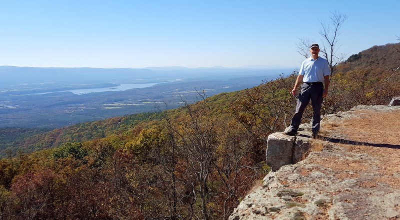
Mount Magazine has a campground (that is full this weekend) and a beautiful new lodge for overnight guests. We hiked down the Old Lodge Trail, and found more vistas of the valley below.

But the most interesting point is where Mark is standing now--the hang-gliders' launch. His outstretched arms are to give him the feeling of what these crazy aerialists see when they leap off this point into the sky.

Denisa is standing a little higher on the hill, so you can see the grassy runway they charge down to give them the momentum to get airborne. There were records posted at the hang glider's shack. Some of those records include the longest rigid wing flight from here of 178 miles in 2006, while the highest altitude achieved was 11,490 feet in 2000. Most amazing seems to be the record for endurance--a flight by a paraglider in 2012 of 6 hours and 4 minutes. All of those records were broken in the months of July or August, so we might be a little late in the year for optimum hang gliding.

It was a great day in Magazine Mountain State Park. We would have liked to camp here to spend more time enjoying the trails, as there were several more that looked interesting. But these winding roads were far away from our route along I-40, and the campground was already booked. So it was a good day trip, and a high point in more than one way.
No comments:
Post a Comment