
Just a short walk away, is the Old Point Loma Lighthouse that was first lit in 1855. Compared to the tall structures that we have visited on the east coast, this light house is a little stubby. That's because it was built on a cliff 422 feet above sea level, so it didn't need a tall tower. The lighthouse keeper was on call 24-hours per day, and the house where his family lived was actually part of the same structure.

The keeper's house, as well as a little museum, is included with the price of admission to this national monument. The good news is that the admission is free for holders of a national park pass.

But this first lighthouse had a flaw. Because it was built on the cliffs over the ocean, fog and low clouds often obscured its light. So in 1891, a new lighthouse replaced it at the tip of Point Loma down at the water's edge.

We liked our viewpoint back up the cliff at the visitor center, where we could look down to see the San Diego bay. In the picture below, we could see the arching Coronado bridge, and the red-roofed buildings of the Hotel del Coronado that we visited two days before. We could also look over the houses and buildings that occupy every open space as far as we could see.

A beautiful tall ship was leaving from the bay, and we could track its progress as it sailed around the peninsula of Point Loma that Cabrillo National Monument occupies.

We think Cabrillo National Monument is a great stop, because it combines the historical with the beautiful. Just a short drive to the other side of the narrow peninsula brought us to the ocean side of Loma Point, where the spring wildflowers are lovely.

This area is known for being a great place to go tide pooling during low tide. But our schedule today had us arriving at high tide instead. So instead of searching through tide pools, we enjoyed seeing the high waves crashing into the seaside cliffs instead.

The pounding water has eroded the sea wall, and carved this dramatic arch. Impressive from our view at the top, we're guessing this arch is really neat from the bottom when the water recedes for tide pooling.

We weren't alone at the cliffs. There were two brave surfers that were trying to miss those rocks as they rode the waves towards the beach. You can see one as a tiny speck on the edge of the wave in the picture below.

All the surfers we saw in California were wearing wet suits. With water temperatures in the 60's, it wouldn't take long to be too cold without that protection.

We traded picture-taking with guests from Canada that were also enjoying the crashing waves this morning.

Besides the national monument, this little peninsula is also a beautiful place for a national cemetery. The rows of white head stones dipped to the sea as a solemn resting place for veterans and their families.

As we left the Loma Point peninsula, we headed north on the coast towards another special place. We stopped at the gliderport launching area of Torrey Pines. We had hoped to watch as glider pilots leaped from this high cliff to soar on the thermals over the ocean. But we talked to one of the pilots, who told us there just wasn't enough wind to make a successful flight this afternoon. He looked out over the ocean to see the shiny surface of the water. He would need a dimpled water surface caused from the wind rippling on the surface to have enough breeze to take off from the top of the cliffs.

So the only way to get off this cliff today would be to walk the 500 steps down to the beach.

The problem with making that climb down is that would put us on Black's Beach. There were a few people enjoying the clothing-optional beach this day, but we headed on down the road instead.

Torrey Pines is probably best known for its championship golf course. It is situated on the cliffs between the gliderport and our next destination--Torrey Pines State Park. We found out that this town is actually named after the nation's rarest pine tree. Torrey Pines are only found here in this state park, and on Santa Rose Island off the Pacific coast. The needles on these unique trees are all clumped in groups of five.

This is Mark standing beside a Torrey Pine tree in Torrey Pines State Park located in Torrey Pines, California.

We are always looking for free things to do when we visit a new area. We found that we would be charged $12 if we drove our car into the state park and parked it in their parking lot. However, there is no charge for walking into the state park. So almost everyone uses the free parking spaces along the 101 highway, and walks in. The large gray triangle in the right hand corner is the empty state parking lot that is obviously used very little. The good news is we found one of the coveted parking spaces along the 101 and saved $12. That also gave us the opportunity to get extra exercise as we walked the length of the beach from our car, and then up the steep slope for this bird's eye view.

We took a great little hike from that vantage point. Besides seeing the famous Torrey pines, we got great views of the spring wildflowers cascading down the cliffs to the ocean. We still aren't accustomed to ocean views with prickly pear cacti in them. The two just don't seem to go together to us.

We had another option for a couple picture at the beach today. We were again high above the water, surrounded by the lovely purple and yellow wildflowers.

The state park also has a cactus garden at the top of the cliffs. We can now recognize many of the plant specimens from the desert. But this Shaw Agave was new to us with its bright red spines catching the afternoon sun.

We actually hiked four different trails at the state park. All of them featured dramatic views of the cliffs and the ocean below.
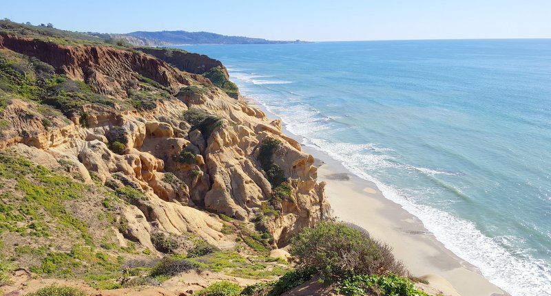
Views like this have made the Torrey Pines area famous. It's a reminder to us that we have wandered into another of God's wonders.

Because of all the rain, several of the most popular hikes that go all the way down to the beach are now closed. The ranger said it will be weeks, or even months, before they will reopen.

So the bad news is that the rains cause flooding and trail damage. The good news is the rain prompted wildflower blooms like this. The ranger told us these flowers had just started blooming this week, so our timing for that was very good.

For the third time today, someone asked if we would like them to take a picture of us together. We seldom refuse when we are asked. Sorry about all the couple shots, but we do have visible proof that after more than two years of hanging out with each other 24/7, we still like each other. We also can say that our smiles also prove that we're still loving this full-time RVing lifestyle and the beautiful places it take us.

No comments:
Post a Comment