
We had a hard start to our bike ride. It seems that these months driving around in the salt-air of the coast and in the Oregon rain is taking its toll on our bicycles. The chains and brakes are rusty, and this morning Mark couldn't get his gear shifter to work.

But it was a beautiful morning, and we had a lovely place to ride bikes. We really like a paved bike path with no cars allowed.

Mark was working really hard pedaling up the hills stuck in sixth gear. Denisa prefers nice level biking trails, and this road had one rolling hill after the other. That was a bicycle leg-burner for sure.

It's a good thing there were some bright bachelor buttons blooming beside the road. We needed their cheery little faces when we were working so hard.

We also saw this red-blooming grass up close since we were pedaling so slowly going up the hills. We had noticed that the medians of the Oregon highways have a new red tinge to them that wasn't there a week ago. This grass is blooming everywhere now.

This is called the Twin Tunnels Trail, because (guess what?!?) there are two old car tunnels along the way.

Even struggling with one gear, Mark can still smile while taking a one-handed selfie while we were going through this part of the tunnel.

Right after the tunnels, we rolled into a rest area filled with wildflowers. So of course, Denisa needed to take a little rest.

We headed down the next section of the highway, and it was downhill. When Denisa remembered that she would have to pedal back up this hill, she decided to turn around. That means she could take more flower pictures.

Mark rode to the bottom of the hill to confirm that was the end of the trail. Then he had to ride back up-hill in sixth gear to find Denisa already rested from her extra time among the wildflowers along the Columbia River.

This was a lovely bike ride, but we were working pretty hard on the hilly sections of this piece of the highway.

We were glad that the last section back to the parking lot was down-hill, as Denisa is a self-declared flat-lander bicycler.

Our next destination today is the state of Washington. The Columbia River is the only thing that separates Oregon and Washington. We have been looking across the river towards this new state, and we finally drove there this afternoon. There are few bridges that cross the wide Columbia, so we paid the toll to cross the bridge at Hood River. On the other side, we could look back south to Oregon to get our first look at Mount Hood. The snow-covered mountain had a row of clouds across its mid-section. But we got our first look at the peak of Oregon's Mount Hood while we were standing in the state of Washington.

Just like Oregon, Washington has a highway that runs right along the Columbia River. There were beautiful views of the blue-green water of Drano Lake with the mountains behind it.

Based on the number of boats anchored in the narrow west end of the lake, we're guessing there is good fishing at Drano Lake.

But the real reason for our trip to Washington is to hike to the peak that is centered in the picture below. We're heading to the top of Dog Mountain.

The weathered sign board at the beginning of the hike maps two different routes to the top of the mountain. In all the trail maps we have seen, we have never seen route descriptive words like "more difficult" and "most difficult." We knew that this was a strenuous hike, and we guess this trail description verifies that.

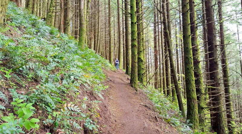
We talked to several different hikers coming down the mountain, asking advice from people just completing the trail. We were surprised to meet a guy wearing an Oklahoma cap. Sure enough, they are vacationing here from Tulsa, Oklahoma. They recommended taking the steepest "most difficult" route up and the less steep "more difficult" route down to make a loop hike. At the time it sounded like good advice. But we have to say it was a grueling 3.7-mile trail with one steep switchback after another. We were completely enveloped in tall trees, so it was also a boring hike with no views. You know it was grueling, when we took only one picture in the two hours it took for our ascent.
But when we got to the upper meadow, suddenly the trees were gone and we were surrounded by fields of wildflowers.

Mark is still wondering if all that work was worth it. This hike has an elevation gain of 2,948 feet spread over only 3.5 miles. That's crazy steep!

Denisa is suddenly rejuvenated. She is running around snapping pictures of wildflowers like a kid. If we look close, we can see red paintbrushes, and tiny purple flowers.

But the star of the show are the radiant Balsamroot that seem to be at the peak of their bloom across the side of the mountain.

The view across that open meadow to the neighboring peaks dusted with snow was also pretty good.

After enjoying our triumph of making it to the open meadow, we had to face the steep trail on up to the summit. It was rocky and steep, but at least we had the beautiful views around us to enjoy. That's the Columbia River far below us now. We have wandered into another of God's wonders!

That trail hugs the side of Dog Mountain, but we are enjoying the blue skies and views around so much that we're not even complaining about how steep this section is.

We celebrate our victory of making it to the summit by eating our well-deserved picnic lunch. Re-fueled, we can now literally point out some of the views from the top. It's hard to tell the difference between white clouds and snow-capped mountains in pictures. So Mark is pointing out where Mount St. Helens is in the picture below. It was a beautiful sight this afternoon.

Likewise, Denisa is pointing to the snow-covered peak of Mt. Hood, barely peeking over the top of the tree-covered Oregon mountain that is between us now.

We add a zoomed in picture of Mount Hood. We have been stalking this mountain since we first saw it from Willamette Valley. Covered with a thick blanket of snow, it's a beautiful sight to see in person.

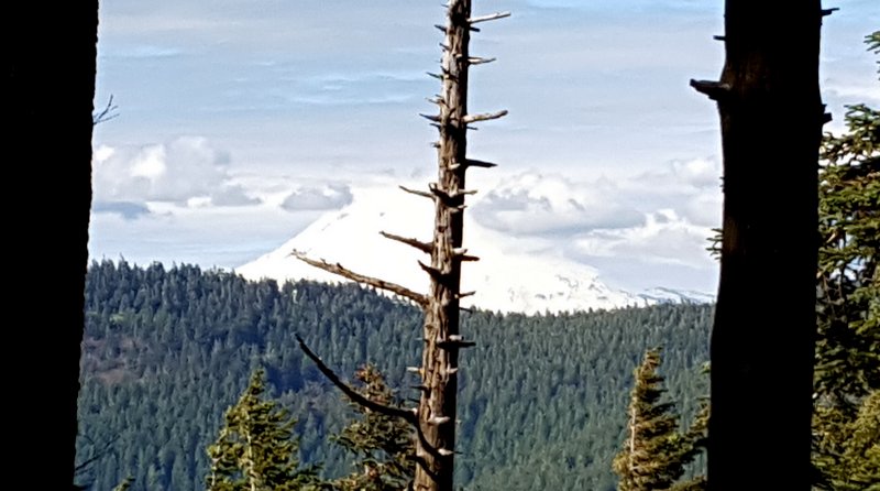
We did some bush-whacking at the summit to get a glance of the closest snow-covered summit--Mt. Adams at 12,307 feet. It's hiding behind the dead tree in the center of the picture, but that was the best angle we could get from Dog Mountain.
There were a few other people at the windy summit at this late hour. We swapped photo-taking jobs with a couple girls that had the 2017 version of a polaroid camera. We haven't seen one of those in a while.

Most people start this hike early in the morning when their legs are fresh. The couple from Tulsa that we met at the bottom of the trail started at 8:00 a.m., so they were finished at 2:00 when we were just starting. That's probably a much smarter plan than taking a bike ride before starting this hike.

We are starting downhill now, still enjoying the views and the flowers. It's at this point that we meet a young couple coming toward us on the trail. We're not sure if this is a compliment or not, but the young woman in her twenties tells Denisa, "You're one tough lady!"

Not as obvious as the big yellow flowers, these subtle chocolate lilies are an elegant addition to the wildflower garden in front of us.

We really aren't looking forward to starting that steep downhill slog through the forest, so we linger longer in the meadow on our way down.

Denisa found a sturdy hiking stick to help with the steep walk down. We're glad that our knees don't seem to mind the downhill walks, because we've heard from other hikers that it can be harder for them than going up-hill. We also can say that the "more difficult" side of the loop was less steep. We wouldn't have been complaining as much if we would have taken that route up-hill.

By the time we got back to the car, the trail head parking lot was almost empty. The sun was low in the sky, lighting up the mountains on the Oregon side of the Columbia River.

We pay our toll, and cross the "Bridge of the gods" that looks like something built from an erector toy set. Meeting a truck on these long and narrow bridges can be a harrowing experience.

By the time we made the drive back to the motor home, we were both dog-tired. It had been a nice bike ride and a beautiful mountain summit, but we definitely know that we should have separated those two activities on different days. But there's just too many beautiful things to see and do in this Columbia River Gorge, and we are running out of pretty days!
No comments:
Post a Comment