
It's great to have a local hiking guide, who knows the best and most scenic route to get to Mt. Wheeler's peak. He also knows about the weather, so we needed to make the summit before afternoon storms. So we were up at 4:30, and on the road by 5:00 a.m. On our drive over to Red River, we surprised a herd of elk on the highway. They were wondering why anyone would be traveling this early in the morning.

It was too early and too dark to get a good picture, but that didn't keep Denisa from trying.

Hour #1
It's mighty chilly this early in the morning when you start a hike at 10,000 feet in elevation. So Denisa was certainly hoping that she didn't fall into the creek on the first water crossing of the day.

That took us to the waterfall, where Brent always offers to take pictures when he leads a hike for Red River's Community House.

Hour #2
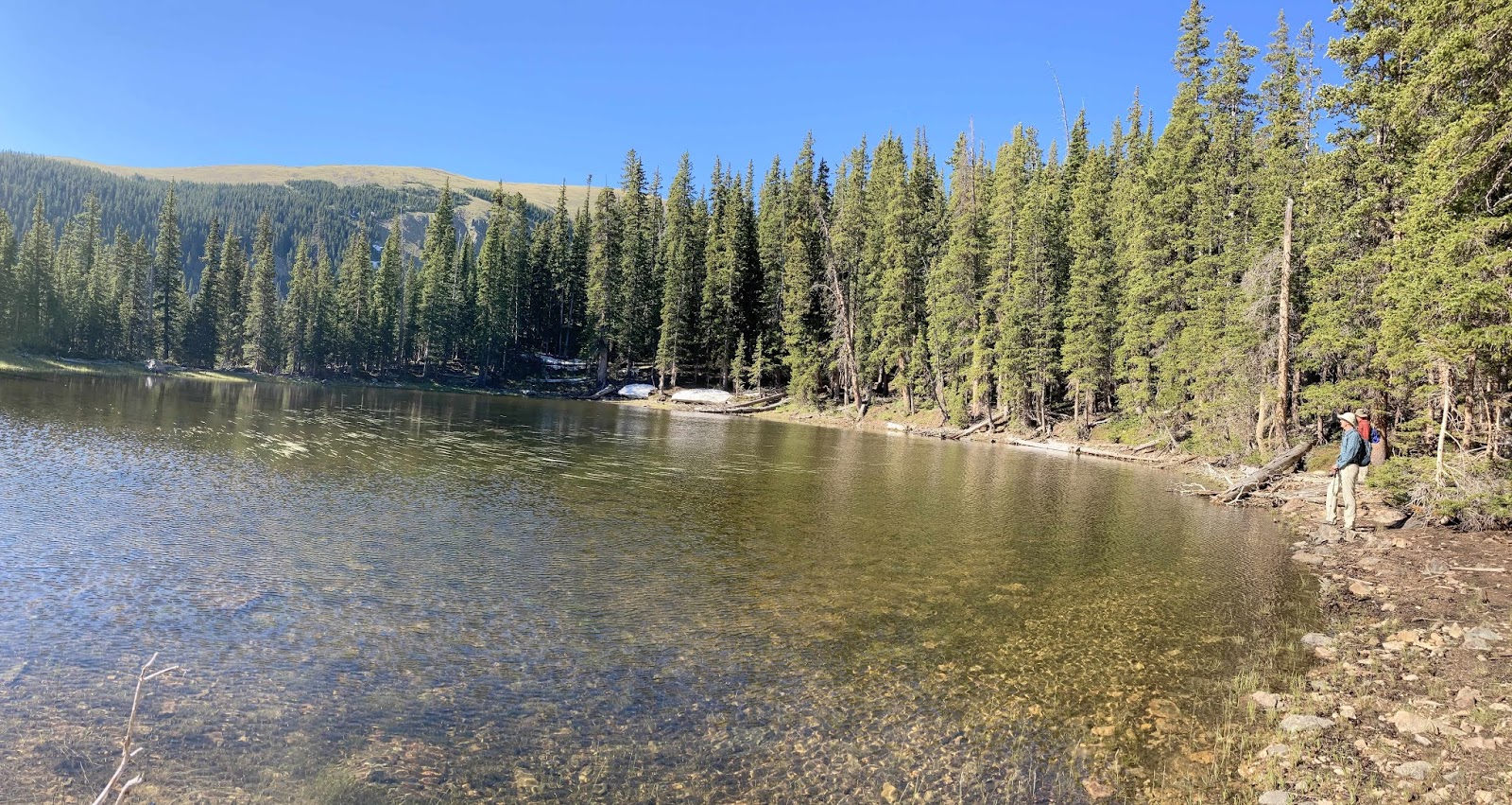
We arrived at Middle Fork Lake, and you can see Denisa in her bright pink blouse on the far right hand side of the lake. The air temperature has warmed a little, and we have worked up enough of a sweat that we have taken off our jackets by this time. This is the final destination for those Community House hikes that Brent often leads, but we are just getting started today.

This is the start to the bush-whacking segment of our trail. No trail connects Middle Fork Lake with the trail we need to be on to get to Wheeler Peak. So once again, we are so glad that our local hiking buddy knows how to get through this forest to where we need to hook up with the next trail.

Hour #3
We're calling this the hour of the hidden lakes. As we're traipsing through the woods looking for our next trail, we happened first onto this forgotten lake. The water is so clear that we can see the rocks and logs on the bottom even from this distance. Again, Denisa is barely visible on the right side of the picture to give some scale to the size of these mountain lakes.

We can tell we are going up in elevation, because we are now seeing some blue sky and the tops of mountain ridges around us.

It was just below the ridge of Fraser Mountain that we found the second hidden lake that we were surprised to see. Welcome to Fraser Lake! Even though Brent has hiked this area before, he's seeing some things that he has never seen before.
Hour #4
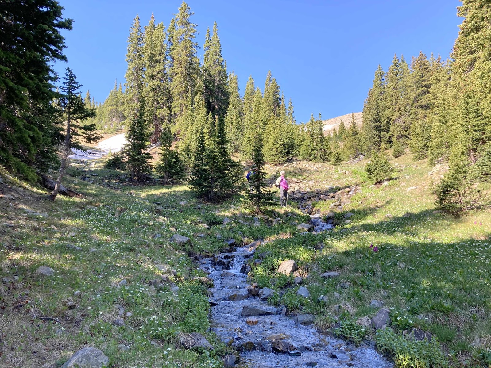
Between finding unexpected lakes, and a continuous flow of water from springs and snow melt, we have entered the soggy portion of the trail today.

The marsh marigolds love all this moisture, and we love the sound of the babbling brooks. It's already been a long time since breakfast, so this was a beautiful place to stop for a snack.
Hour #5
After some steep traipsing up stream beds, we finally crest the top of the ridge to get some good views of the mountain tops around us.

One of views we can see now are the Taos ski resort trails cut into the mountain in front of us.

We're walking through boulders and snow to get to the top of this ridge for those views.

We're above tree line now, in the middle of So Cal Meadow.

The good news is that we can finally see the Bull-of-the-Mountain Trail etched into that tree-less mountainside ahead of us. Again, we're heading straight up into air that is certainly lacking in oxygen. You can see Mark in the corner of the picture, but you'll really have to concentrate to find Brent (hiking far in front of us) in the middle of the photo.

As we zig-zagged up the side of that mountain face, it was nice to once again be on a trail.

Hour #6
We're taking an unusual route to Wheeler Peak, and we haven't seen another hiker for those first five hours. We had to stop to visit when we met a couple coming down from the summit with their three dogs. One of those dogs was very friendly.

Brent has designed a loop hike for us, and we will walk by Horseshoe Lake after we get up to the summit. As we look down on it now, we can see that it's obvious why the lake was given its name.

Lying down on the slope of that mountainside are a pair of bachelor bighorn sheep.

We are hiking across more expanses of snow as we go higher up the mountain ridge. Mark mentioned that it would be hard to stop if you ever started sliding down that slippery slope. As she made her way carefully across, Denisa kind of wished he hadn't mentioned that.

Wow, the air is thin up here, but it is certainly glorious to be on this high ridge!

We can look down into the bowl of mountains below us now, to see where we were hiking earlier in the week. If you look closely in the very middle of the picture below, you can see a tiny blue circle. That is Williams Lake. It certainly didn't seem so tiny when we were standing beside it several days ago! That day we hiked through the forest on the left, and close to the mountain-tops that are now far below us.

Most hikers will summit Wheeler Peak from the hike that goes by Williams Lake. That is the shortest and most direct route. But we are taking the more scenic route as we come to the end of hour #6. Along this ridge we can look down to see two mountain valleys below us. Denisa is standing on the ridge where she can see the Horseshoe Lake valley on the left, and the Williams Lake valley on the right.

Hour #7
This is the hour of the summits! It's plural because we will actually hike to two different 13,000+ peaks along this ridge. The first is Mount Walter. Mark is standing beside the official peak marker that tells us it was named for H.D. Walter--"who loved these mountains." We have to say that we like them a lot as well!

We are welcomed to this 13,141 feet peak by the resident marmot. He was hanging out right by the sign, and didn't seem to mind having company.

We didn't pause for long, however, before we were back on the trail--a trail that was heading straight up.

As you can see, Brent is already at the top as we're starting that last push to the summit. He doesn't have to wait around for pictures like the Engelmans.

We made it! We had to pose for pictures on the summit of Wheeler Peak. Its bronze marker declared that its height is 13,161 feet--the highest point in New Mexico.

It was named in honor of Major George Montague Wheeler (1832-1909) who led a party of surveyors and naturalists for ten years. We're guessing that he loved these mountains too.

We have been wandering God's wonders all day, but we are at the peak of those wonders now. We can look one direction to see this set of snow-laced mountains to our west.

Looking to our east, we see where we will begin our descent towards these iron-laced mountains with their characteristic red color.

Hour #8
It's all down-hill from here as we begin our descent from Wheeler Peak into the Horseshoe Lake Valley.

We ate another snack at the peak, but Brent wants us to be off the summit before the afternoon thunder storms begin. The changing light is really picking up the colors of Red Dome in the background.

The clouds are building as we take a few more pictures. We are still above tree line and have great views in all directions.

Within thirty minutes we are approaching Horseshoe Lake, and we can see that characteristic shape up close.

The skies are completely cloudy now, so we need to hustle to get below tree line before it storms.

But there are so many beautiful things to see. After viewing God's majestic wonders from mountain-tops, we are still amazed with God's tiny wonders like a colorful moth posing on a bouquet of yellow wildflowers.

If you lay on the ground so you can take a picture of that moth and bouquet with Horseshoe Lake in the background you can get the tiny and majestic wonders into one picture.

We're going through more patches of snow, that are getting smaller and slicker as they are melting this summer.

They are so slick that a sure-footed hiker like Mark will even fall down crossing this patch. He was quick to stand up, so Denisa missed getting his picture in a prone position.

Hour #9
We shall call this sixty minutes, "the hour of the Rocky Mountain bighorn sheep." We found our first group of young sheep with spiky horns nibbling on the foliage not far from our trail.

Some of this small group were still hanging on to parts of their winter coats.

We spotted a more mature ewe making her way across a rocky mountain side.

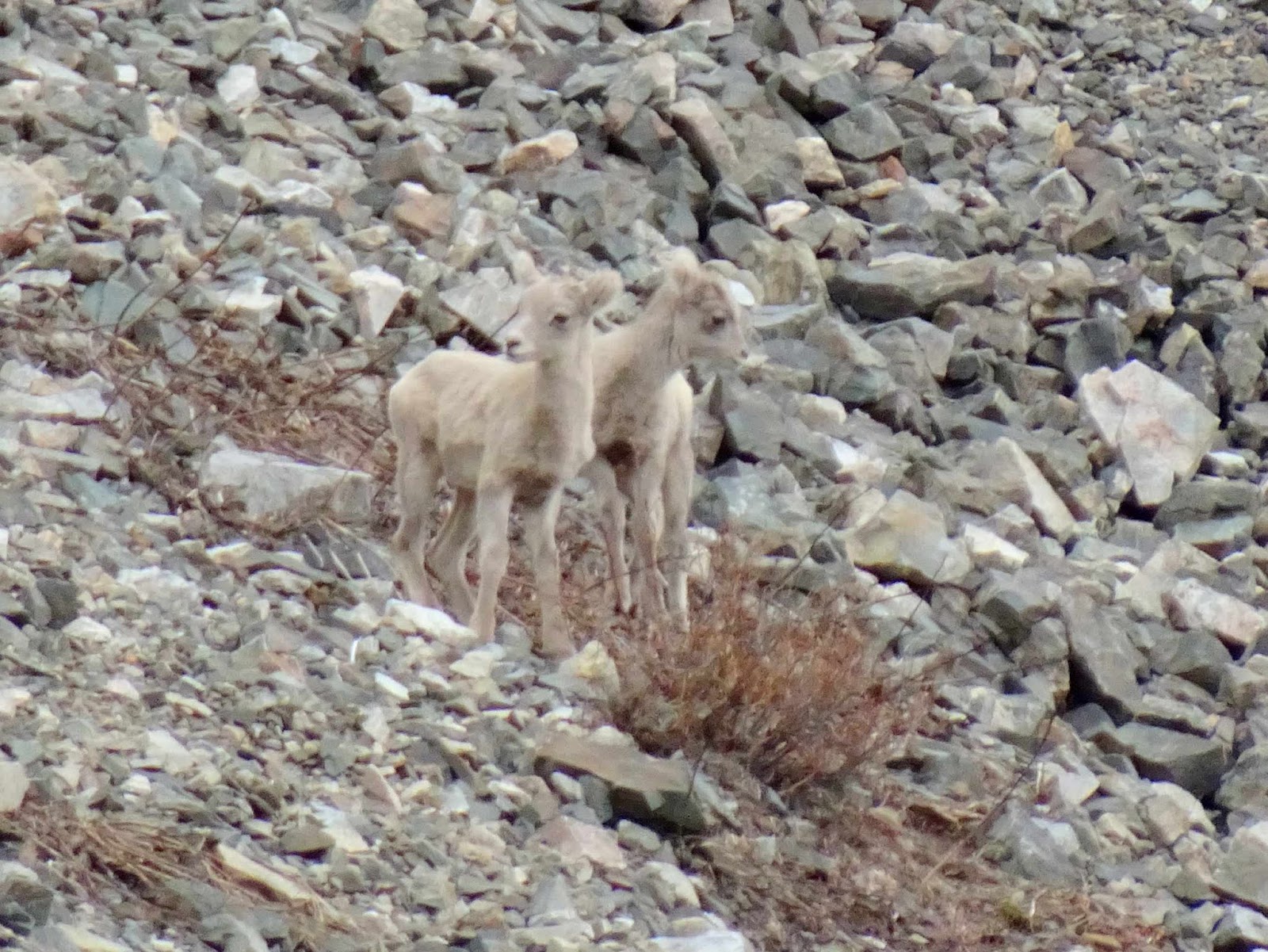
Then we spotted the nursery where all the lambs and their mothers were hanging on the side of the mountain in the rocks and snow.

The babies blended in well with the color of their rocky environment.
We watched as the lambs played and scampered down the rock face. But their favorite game was butting heads.

Every time we would put the camera away because we really needed to be going, they would do something else too cute to miss.

After we finally pulled ourselves away from the lamb-show, we headed on down-hill. We're beginning to see trees again.

We continued to walk among some gorgeous forests and rock formations, but we are no longer pausing to take pictures. Mark is taking them on the run from his position at the rear of this hiking troupe.


Mark held back to take a picture showing how big our landscape still was, even though we are now at a lower elevation. If you look closely, you can see Denisa at the base of that rock wall.

We will pause to take a picture of an unusually colorful old pine tree. God's wonders come in all shapes and sizes.

Hour #10
The storm that has been building has finally caught up with us as we arrived at our final point of interest. We have found Lost Lake just as the sprinkles begin to fall. Normally we would have stopped long enough to take a few more pictures, but this was our quick snap at hour #10.

We took cover and rested our legs while we waited for the rain to pass. It was not a long or powerful storm, and it gave us a chance to eat the lunch that we had packed many hours before. By the time we finished our crackers and tuna, the shower was over and we were on the trail again. A little shower is good for the flowers, and Denisa loves the purple columbines that are beginning to show up at this lower elevation.

After ten hours on the trail, our senses are numbed to all the grandeur around us. We are now hiking through the forest, with less views of the mountains. Since we are on a loop trail, we are still seeing new territory, but the only pictures we are taking now are of the unusual flowers Denisa spots near the trail.

Hour #11
We are on automatic pilot now, as we just keep following our faithful leader down the trail surrounded by trees. Our legs and feet are ready to be down off the mountain, but our hearts and eyes are still amazed from all the wonders we have enjoyed today.

At 5:46, we were back to our vehicle at the trail head. Mark had been recording our hike in his AllTrails app, and it gave him the following summary: We had been on the trail for almost 12 hours total. We had hiked 17.1 miles, with 3,930 feet in elevation gain, and burned approximately 5187 calories. It's hard to summarize a hike like this with just a few numbers, so that's why we take so many pictures! We were blessed with a great hike leader for such an epic hike. We made it to the high point of New Mexico, and it will be one of our best hikes ever. How could this day get even better? When we arrived back to Red River, Melinda had supper ready for us! We finished a 12-hour hike off with home-made ribs with all the trimmings, and just-baked chocolate chip cookies. Besides hiking to the highest point in New Mexico, that's another highlight for the day!
Great blog you haave
ReplyDelete