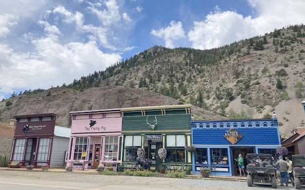
The first summer after we retired, we spent three weeks in the town of South Fork, Colorado. Now five years later, we are back and re-exploring this area. Today we are driving the Silver Thread Scenic Byway--the road that heads north out of town. Twenty-three miles down that road, we arrived at our first stop in the village of Creede, Colorado.
At the end of the main street, the road continues up into the mountains on the 17-mile Bachelor Loop that we drove last time.
But today we are not taking that loop, because we are heading further up the Silver Thread Scenic Byway (aka Highway 149) than we have ever been before. So we drove by Creede's iconic fire station--carved into the mountain-side--and head further up Highway 149.
We are in mining country, and our second stop is at this mining site just a few miles past Creede. Closed now, they once mined bentonite clay here. During World War II it was used to make ammunition. But in peace times it was used for less explosive products like face powder and an ingredient in salt water taffy.
From there, our road dips out of the mountains and onto the high plains. Then it suddenly breaks away into a canyon with a beautiful waterfall pouring water off the edge. Our third stop is just a mile off the highway, as we get our first view of North Clear Creek Falls. We also get a first look at Mark raising his arms at the top of the falls, but he's so tiny he's hard to find.
If we zoom in a little, perhaps you can spot him standing on the edge of the rocks on the left side of the waterfall.
Just in case you haven't spotted him yet, we'll zoom all the way to his comfy perch on the rocks above the falls.
From there he can look straight down the falling water to the canyon floor over 100 feet below.
 |
Back on the Silver Thread Scenic Byway, our fourth stop is close to Slumgullion Pass. At an elevation of 11,529 feet, the north side of the pass has the steepest grade of any continuously paved road in Colorado. Five years ago we were afraid to take the motor home up and down this pass. But after driving it in the car today (and after five years of conquering mountain passes all over North America), we would take the motor home over Slumgullion Pass now. From a viewpoint close to the summit, we can see fifteen miles away to the San Juan Mountains and the Uncompahgre Wilderness. That includes 14ers like Uncompahgre peak in the distance.
This stop is also educational. Here we learned the tale of the nearby flat-top mountain--Mesa Seco. About 850 years ago, the entire side of this water-saturated mesa broke away and slid down the face of the mountain. This rolling mass of mud continued down 2,000 feet in elevation through the valley below. Thousands of tons of water-saturated earth moved four miles downhill.
As we progressed down the Silver Thread byway, we could see parts of the four miles of red and yellow earth that is now known as the Slumgullion Earthflow.
Those tons of earth stopped at the bottom of the valley, damming the Gunnison River and forming Lake San Cristobal--the second largest natural lake in Colorado.
Hundreds of years later, the valley surrounding the lake is still made up of heaps of Mesa Seco's yellow soil that oozed down the mountain that rainy day. Geologists estimate that it is still moving downhill approximately twenty feet per year.
We drove all the way around Lake San Cristobal. Its lovely turquoise water is surrounded by tall mountains, and we were intrigued with the grassy inlets to explore on the west end. If it wasn't so windy, we would have surely been kayaking here today.
After our tour of Lake San Cristobal, we headed into the town that was named for it--Lake City. This little village is centered between the well-known towns of Creede and Gunnison, and it's a cool place in the summer at 8,660 feet in elevation. This village was also the Hinsdale county seat in 1877, and that original building is still standing.
In fact there are over 200 historical structures in Lake City--including a few barns and a couple outhouses. The little downtown had some very colorful historical buildings, set in the little valley surrounded by mountains.
Denisa likes the brightly painted store fronts, and she especially loves the brightly-colored flowers spilling out of the hanging baskets.
Some stores had feeders next to their flower baskets, and the hummingbirds were whizzing past her ears as Denisa tried to take pictures of these tiny birds.
Lake City was our furthest destination on this day-long road trip down the Silver Thread Byway. After a stop at the town's bakery, it's time to make the return trip back down Highway 149. We had noticed that the trunks on the aspens along the road aren't the usual bright white color. Instead, the trunks were almost yellow in color.
While Mark was hanging on to one of those aspen so he could lean out and take a picture of the Slumgullion Earthflow, he discovered that a powdery yellow substance comes off those trunks. A google search educated us that it is normal for aspen trunks to slough off this powder. Aspens have few leaves, and they actually carry on photosynthesis through their white trunks. One source said that if they didn't powder like this, they would have rough trunks like most trees, instead of their smooth white trunks.
The mission for our return drive was to find a nice mountain lake to kayak. That took us on some interesting gravel roads off the Silver Thread Byway. Our first stop at Rito Hondo Reservoir was a little disappointing since it was almost completely dry.
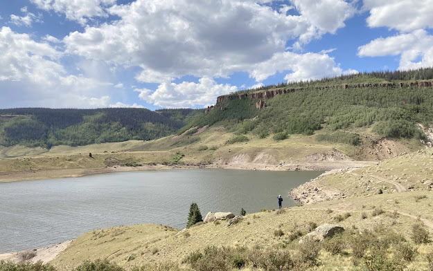
Our next stop at the Continental Reservoir was much better, but the afternoon winds had picked up so there were waves on this long thin lake. Maybe we'll return another day to kayak here.
But our drive down that long gravel road was not in vain. We found some tall rock formations above the road that were just begging us to climb up for the view. It didn't take Mark long to climb to the top of his rock.
On the other hand, Denisa was content to sit at the bottom of her rock.
You can barely see Denisa sitting at the bottom of the picture below, with those tall rock spires reaching high into that beautiful blue sky this afternoon.
We have been traveling along the Rio Grande River today, and our next stop led us to a view of the headwaters of this grand river. It starts in the 13,000-feet mountains of the San Juans that lay in front of us.
The river flows through Brown Lakes, and we will record it as another nice possibility for a kayak trip on a less windy day.
It was near the lake that we spotted the mule deer buck with the largest set of antlers of the summer.
Instead of stopping at the usual view point to take the picture above, of course we had to hike a little further for a closer look at the falls.
We visited its northern cousin this morning, but this smaller South Clear Creek waterfall was a nice stop this afternoon.
Camping neighbors suggested that we stop for a meal at Freemons General Store, and we managed to arrive just thirty minutes before closing time. Literally in the middle of no where, this little gem is definitely what two hungry road-trippers needed.
We ate our burger and waffle fries at a picnic table by the river, overlooking the high mesa. We haven't eaten inside a restaurant all spring and summer, but with views like this, who would want to eat inside?
As we drove our last few miles down the Silver Thread, the golden sun was lighting up the mountains around us. We have traveled 74 miles up this thread today, but with our detours on the gravel roads and our return trip we've logged about 200 miles. That's a long road trip for us, but it was a great day of wandering more of God's wonders on the Silver Thread Scenic Byway.


No comments:
Post a Comment