Denisa likes paper maps. She likes to hold them in her lap when we are driving, even though we have the big-rig GPS and the cell phone's google maps barking out turn-by-turn directions. She likes highlighting our route on the paper map in different colored markers for each motor home moving day. She likes looking at a paper map for unusual places to stop. That's how we found the new-to-us City of Rocks National Monument. She found it on her paper map at the border between Idaho and Utah. It's a 50-mile drive from the route we are taking in the motor home, but that is the reason we made the stop in Heyburn, Idaho. We were up very early this morning to make that 50-mile drive. We arrived before sunrise at the City of Rocks Visitor Center's outdoor displays.
Between 1842 and 1882 a mass migration of people headed west. This park is situated right on the California Trail, used by 200,000 emigrants in wagons to make their way to a new life in the far reaches of the western United States.
As they passed this wide desert prairie, they wrote journal entries that described the spires and cathedrals made of rock here as a "silent city." This journal written in 1857 describes their day exploring "the sights of the city. We were . . . spellbound with the beauty and strangeness of it all."
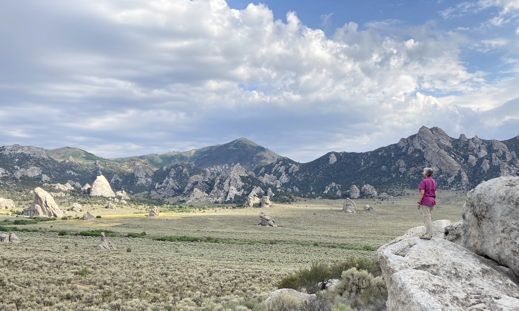
Today we climbed up on the adjacent rocks and looked over the silent city made of rocks, just like the travelers from the 1800s.
As usual, Mark is better at scrambling up on the rocks for the best views. Can you see him standing between the rock knobs in the picture below?
Besides scrambling on rocks, the travelers from the California Trail left their mark on the City of Rocks. This is an example of one of the "Register Rocks" in the park.
They used the white rocks as their tablet, and axel grease as their ink to write their names and dates and messages for future travelers to see.
These are big rocks with lots of room for messages! On the signboards in the park, it was fun to read excerpts from people's journals that told of the day their wagon trains stopped here at City of Rocks.
Here's another example of the huge rocks that randomly arise from the surrounding prairie. This one is called Elephant Rock, but it is bigger than even the biggest pachyderm. You can see Mark in the bottom left hand corner of the picture below, looking very little next to Elephant Rock.
They have 22 miles of trails inside this national monument park, and for once we didn't feel obligated to walk all of them. In fact, we only hiked the 1.7-mile Creekside Towers loop. It took us to places like "Closet Rock,"
and rocky spires jutting out above the trees on the trail.
But our favorite thing to do in the park was to stop at the many view points, and scramble on the rocks. We make a good team--Mark scrambles, and Denisa takes the picture.
Some of the rocks have names on the park map, while others do not. We named this rock structure, "Stack of Pancakes."
Occasionally, the neat rocks were in places where even normal people can walk. Then Denisa can be in the pictures too.
Her favorite was Window Arch, where we can show off the blue skies and clouds. We have seen some smoky-sky-days, so we are really enjoying the blue skies today.
While some national parks and monuments have signs that you must stay on the trail, or you can't climb on the rocks, City of Rocks encourages visitors to explore and climb. It was like visiting a playground for mountain goats like Mark!
This playground is especially well known among rock climbers, and we found a number of them making their way up rock faces today. We zoomed in on this climber with a bright red shirt,
because that made him easier to spot as we took pictures of his progress up this rock wall.
Can you still see that red shirt in the middle of the rock, making his way up very quickly?
We are amazed to watch his progress up that vertical rock wall. We don't understand where he is finding notches for his feet and hands.
The park has about 700 developed climbing routes, that range from 30 to 600 feet high. These routes have bolts drilled into the rock faces for securing safety ropes. There are several climbing routes on this large boulder named "Parking Lot Rock." Perhaps it got that name because spectators can sit in the parking lot to watch the climbers' progress easily.
When our climber got to the top, we expected some celebration. But instead, he attached himself to the chain at the top, and then he became the safety rope holder for his friend that started the climb from the bottom.
Again, we expected some high-fives as they congratulated each other on their accomplishment of both making it to the top. But instead, they went to the work of changing their ropes to begin the descent.
They might have been in a bit of a hurry, since the sun was beginning to peak over that Parking Lot Rock, making their descent much hotter.
In this hot desert-like location, Denisa can still find flowers. This red and yellow Western Columbine was very happy in this environment.
She also took pictures of this small-leaf bush that provides a touch of green between these boulders. Perhaps these curious curls are the "flowers" or the "seeds" of this bush?
We arrived at City of Rocks at sunrise, because the forecast predicted it was going to get hot today. That forecast wasn't wrong. As we made our final drive out of the south entrance we took a few more pictures of the rocks that dwarf the cars parked next to them. We have wandered into another of God's wonders today.
The last point-of-interest on the park map is called "Two Sisters." It is mentioned many times as a famous landmark in diaries kept by California Trail travelers because it dominates the horizon as it emerges from the flat prairie around it. But approaching from the park road, we see four peaks and wonder why it isn't called "Four Sisters."
We are always amazed at how rocks change shape from different angles. As we drove closer and the road curved in a different direction, we can now see only two sisters.
We arrived today at the main park entrance on the east side at the tiny town of Almo. That was a nice paved road, that turned to a smooth gravel road throughout the City of Rocks National Monument. We decided to take the south exit out of the park, and make our return to Heyburn on a road that ran along the west side of the park. We probably wouldn't recommend that rough, narrow gravel route to others. We were five miles or so into that lonely road when we saw a cluster of vehicles on the side of the road.
We looked behind us to see a blackened top to the hill that we had just passed. We later found that a lightning strike had started a fire here beside City of Rocks last night. The firefighters had worked through the night, and were still monitoring hot spots as we drove by this afternoon. Now we know we were VERY lucky to have the smoke-free blue skies that we enjoyed today.
It was another interesting day of our wanderings, as we explore more of God's wonders that we find on those paper maps along the way.


No comments:
Post a Comment