Just ten miles from our campground near Great Basin National Park, we passed the "Welcome to Utah" sign. That's when we also lost an hour as we changed our watches officially from Pacific Time to Mountain Time. Yesterday we were hiking so close to this state border that our phones kept automatically changing time zones as we walked up that mountain.
We have a little smoke in the air, as the distant Confusion Mountain Range views are a little hazy. But we have good air quality, and we're still glad to see the blue skies up above. Today's drive has long stretches of desert valley with occasional climbs up to passes through interesting mountain ranges.
If you remember, the Nevada section of Highway 50 was dubbed "The Loneliest Road in the U.S." We have to say that the first section of Highway 50 in Utah was also very lonely. We're still in a desert basin with nothing on the horizon and no roads that intersect with this long ribbon of highway. You shouldn't be on this road unless you want to head straight east, because there are no roads going either north or south for the next 85 miles. A few turnouts lead to gravel roads that dead end at places like Devil's Canyon or Snake Creek. Neither of those spots sounded very inviting. There are also no services, no houses, no towns . . . just lots of sagebrush.
After 85 miles we arrived at Delta, Utah, the first place to buy milk, eggs, and bread. We're out of all three of those items. We also saw the first green grass, with some dairies and irrigated crops around Delta. Instead of continuing straight east, then we had to make a Z-shaped route around the wall of rock mountains in Fishlake National Forest.
As we neared the town of Salina, Utah, the mountains turn to white chalky hills. But we are loving the blue skies and white clouds for our drive today.
Nine miles east of Salina is a free Forest Service campground that Mark found on one of his camping apps. With temperatures in the 90s today, we appreciated the shade trees that we could park underneath.
We have no hook-ups, but we do have a spacious site and a picnic table. And, the price is right. This is our fourth night in a free no-hook-up site, and that helps to average out some of our expensive stays in the northwest.
A creek runs right beside the campground, and several trails leave from here (after you ford the water). But with hot afternoon temperatures, we're not interested in a walk in the desert anyway.
What we are interested in is making some reservations for future travel. We're traveling faster than usual, and we need to find campsites across Utah and into Colorado for the holiday weekend. We are also making reservations for an upcoming trip to Canada. Our site here would be perfect, but we have absolutely no phone signal. In order to make those reservations we had to drive the nine miles back to Salina, where we hung out inside the air-conditioned town library for the afternoon. It wasn't a glamorous day, but one that we needed. The setting sun was lighting up the hill-sides as we drove back to the motor home after the library's closing time.
The next morning we continued our trip east across the state of Utah on Highway 50. We'll be traveling 150 miles today across this lonely highway. But looking at her paper map, Denisa saw that there were four different road-side rest areas with parking. Much to our delight, we found that we were entering a scenic byway that featured different geological features. The pull outs allowed us to see each one of them more closely. The first rest area gave us this view:
The next rest area featured a red butte to the north,
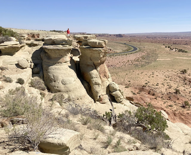
and white hoodoos with caprocks to the south. Denisa was pleased with the picture of Mark standing on the first white column closest to the cliff.
But Mark thought the views from the second column were better. So Denisa snapped another picture.
She also snapped a picture of the wide jump that Mark had to make to get to that far column. We had to leave the rest area quickly before he tried more rock jumping.
The next section of Highway 50 features white domes that the highway snakes between.
The third rest area featured a deep canyon,
and Ghost Rock.
The fourth rest area features an entirely different color and kind of rock.
It's amazing that the colors and textures of the rock have changed so dramatically in this reasonably short distance. One road side sign explained that we are driving through the San Rafael Swell, caused when forces below pushed up different layers of rock in the earth's crust.
We explain it that we have been wandering through more of God's wonders in Utah.
Moments later the colors and textures change once again as we continued down Highway 50. That's when it was time for us to turn south for a little detour.
Even though we are in a bit of a hurry in our drive across the country, we have decided to head towards Moab, Utah. We just can't drive through Utah without visiting more of this scenic state.


No comments:
Post a Comment