The Last of the Arches
We hadn't even planned to stop at Moab because everyone knows it is too hot here in August. But after hearing great things about this area, we opted for a three day stop. Now we are waiting for news about a medical emergency at home, and thought it best to not go further down the road. That gave us time to explore another area of Arches National Park, so we set that 5:00 alarm again. The smoke in the air has brought red sunrises and sunsets, and the sun was just coming over the horizon as we neared our destination.
We were heading to the Devils Garden Trailhead at the very end of the park's road. We were surprised to see a number of cars already at the parking lot. We won't be getting the early riser award this morning, as we visited with a couple from Provo, Utah, that left home at 2:30 this morning to make this hike.
There are seven arches in this 7.2 mile hike, and of course we had to go to each one. First is the Tunnel Arch, and we were fenced in from getting any closer to it.
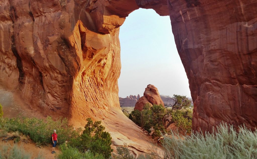
The second arch is the Pine Tree Arch, and we could stand right beside those pine trees that it is named after.
The rising sun is now lighting up the eastern side of the arches, so we had to take another picture from the east side of the Pine Tree arch. It's hard to recognize where the arch starts and stops from this view, as there is a large rock wall right behind it.
Those pine trees have lots of green pine cones on them, so it might be a very good year for pinyon nuts. We thought they wouldn't be opening until the fall, but Mark found this opened cone on the trail. He also harvested five pinyon nuts. He was obviously watching the raven's technique a couple days ago. But we don't remember seeing that the raven got as sticky as Mark's hands got. His hands would smell like pine-sap for the rest of the day, and holding his hand literally meant we were stuck together.
One of the most famous arches in the park is Landscape Arch. This is the longest natural arch in the world, measuring 290 feet. That is almost as long as a football field!
Now just a ribbon of rock, the path to the arch was fenced off since
large slabs of rock have fallen from its thinnest section three
different times since 1991. These were sizable slabs measuring 30, 47,
and 70 feet in length. Its a good thing to see this arch now, because
another fall like that might turn it into two landscape nubs.
The walk between arches is on a trail, but very often that trail is straight uphill on slick rock. You can see that many feet have smoothed this hill that lies between large walls of rock.
The fourth arch actually has two openings, and is called Partition Arch. We're both pictured in the top opening because some new friends from China offered to take our picture together.
Denisa is still in the upper arch, while you can see the two of them in the larger lower arch. They are visiting the United States on their honeymoon, and were very appreciative of our help with reading the map and directions between each arch.
The fifth arch, Navajo Arch, was the hardest to photograph. It was harder because there isn't room to back away from it. But it was also harder because there was a couple from Los Angeles that were going to great lengths to get the perfect shot, so they were always in our way. Note to self--don't be that obnoxious photographer that doesn't share arches well with others.
While Denisa is usually content to return to the path on the ground, Mark is always looking for an alternate path that usually includes climbing over something. True to that form, he climbed over boulders at the end of the canyon. Since he had the camera with him, he took pictures of Denisa down on the normal people trail. I guess that statement means that Mark is not a "normal people."
It was after 9:00 by the time we hiked to the Double O arch.
Again, we couldn't get very close because of the following sign that was posted nearby:
This picture clearly shows the lighter colored stone that was left on top of the smaller O after the slab of rock fell.
The last arch of the day was Private Arch. As its name would imply, we had to walk quite a ways off the loop trail to get to this arch.
We could take pictures from both sides, so of course, we did. We had private arch to ourselves, which was another great reason to start this hike early. In the course of the morning, we kept crossing paths with four other couples that started this hike about when we did. By the end of the 7 miles we felt like old friends. We use the term "old" loosely, considering that we were twice their age.
After all the arches were found, it was a long hike back to the car. There were some fun sections, however, like these rows and rows of sandstone fins standing parallel to each other.
Some of those giant fins were just asking for someone to crawl up them, so Mark (of course) will oblige.
We took the primitive trail that made the hike into a loop. Because fewer people make this loop, it was a quiet slog through some thick sand. It was on this quiet section that we met up with a team doing search and rescue with the same color shirts that Mark was wearing. They explained that a 16-year-old boy was last seen yesterday morning, so we unofficially joined them in the search for the rest of our hike. We thought about the heat and going without water in this desert for a day, and we prayed for him the rest of our walk to the car.
As we got back to the beginning of the trail, we were amazed at the mass of people starting into Devils Garden. That empty parking lot was now full. Arches National Park hosts over a million visitors each year, and most of them seemed to be on this trail this day. Most will go to only a few arches and won't take the loop because of the heat. But we were glad we got to enjoy these wonders in the cool and calm of the early morning. We have enjoyed Arches National Park, and feel so blessed to be able to live just a few miles away for this week so we could really explore it.


No comments:
Post a Comment