We headed west out of Port Angeles, and turned down the Elwha road. There are 9 different sections of this very large Olympic National Park, and we plan to visit most of them during these three days. We started our morning with an easy hike towards Madison Falls. It was early, so we thought we would be the only ones on the trail. But we were surprised to see another very slow hiker in the center of the trail.

We outpaced the snail, so we had Madison Falls all to ourselves.

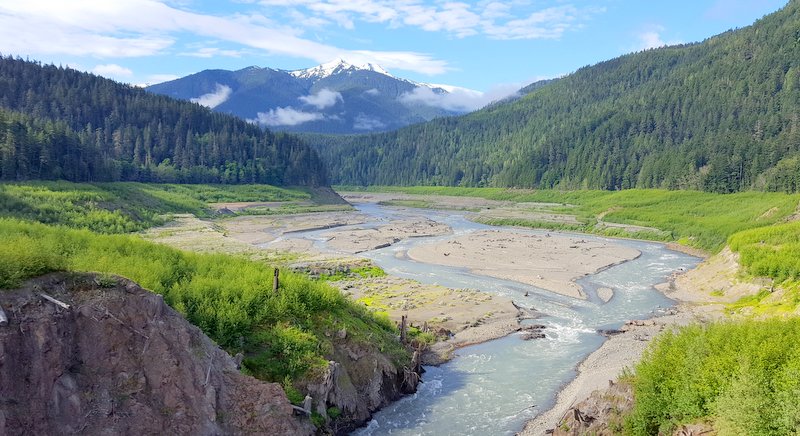
Since we were already on the Elwha road, we stopped to take a picture of Elwha River that flows down the mountain here. We noticed that it is a milky blue color. That is from the glacial silt that comes with the spring thaw at the top of the mountain.

We hadn't planned this detour, but this river has a very interesting history. So we decided to drive further down Elwha Road to see where the Glines Canyon Dam used to be.

In the early 1900's the dam was built in this very tall canyon to form Mills Lake. It also housed a hydro-electric plant that fueled industry along the peninsula for years. But in 1992 Congress appropriated the money to remove this dam and return Elwha River to its natural course. You can barely see Denisa, standing on the right side of the picture behind the white fencing. There used to be a tall cement dam that filled the gap between her and the white fencing seen on the left hand side of the photo.

We took a picture of the informational sign that showed what this area looked like twenty years ago, with the blue waters of Lake Mills behind the tall cement dam.

It took a 10-year plan to figure out how to remove the dam and reseed the lake bed with native vegetation. Now the un-dammed Elwha River meanders through the valley that used to be covered by Lake Mills.
For years, native salmon couldn't spawn up the Elwha River because the dam blocked their natural course. With all the planning in place, they are now back in the river. We can also report that the deer are enjoying this newly naturalized area.

When she gets wildflowers and a deer in the same picture, that's a double bonus for Denisa.

The lupines are really blooming at this elevation, and make a pretty picture with the new river valley in the background.

Our next stop along Highway 101 is Lake Crescent--appropriately named for its crescent shape. We pulled into the east bank area to see the lake situated among the mountains and the clouds. We can see one of the peaks peeking through the clouds, with just a touch of blue sky this morning.

The clouds are covering the blue skies we have been enjoying this morning, and the highlight of the stop here were the ducks on the lake. This male mallard had obviously been fed on the bank, and he headed straight toward us. You can see how clear the waters of this mountain lake are, as we could see all the rocks through the water below Mr. Duck.

Even though we don't feed wild animals, he was persistent. He literally sat down at our feet waiting for a hand-out.

He has beautiful coloring, and it was great to have such a good model to photograph.

That would have been our favorite duck encounter of the day, if Mother Duck and her 5 ducklings hadn't waddled out of the woods beside us.

The fuzzy ducklings were hard to photograph, as they aren't nearly as sedate as Papa Duck. But of course, Denisa tried any way.

Mom had no qualms about parading them right in front of us. Mark hadn't moved this whole time, and he got a front row seat to the duck parade.

We have been blessed with some majestic sights here at Olympic National Park so far, but we are also loving the wildlife that abounds here.

It was hard to get Denisa away from the duckling show, but we had more hikes to do today. We drove around Crescent Lake on our way to the next hike, and got a view of the lake from the other side with a little more blue sky behind it.

We stopped in at the Storm King Ranger station to take the hike to another waterfall. This 1.8 mile hike took us through forests of old growth trees that remind us of the redwood forests.

It usually takes some river crossings to get to a waterfall, and this was an interesting one. Mark is standing on a log that was just wide enough for a one-person crossing. He's used to crossing rivers by walking on logs, but Denisa particularly enjoyed having the hand rails this time.

It's only 10:30 this morning, and we've already been blessed with two waterfalls today. This is Marymere Falls, a horsetail fall plunging ninety feet out of the Olympic Mountains.

Next stop on Highway 101 is another national park section--Sol Duc. Most famous for the hot mineral springs resort here, we wanted to hike to the waterfall instead. We had to drive 14 miles to the end of Sol Duc road, and then started the trail. On the way to the big one, we got to see smaller waterfalls trickling down the green mossy face of this mountain.

It's a 0.8 hike to Sol Duc Falls. The bridge over Sol Duc River gave us our first view of the falls. If you look very carefully, you can see Mark standing with upraised arms at the top of the falls above the log. Don't ask how he got there.

Here's another view of the falls from the bridge. We include this picture too just because Denisa got drenched on that viewpoint to the right. The waterfall was so powerful that it was like standing in the shower with all the mist in the air.

Our next stop is a short loop hike named the "Ancient Groves Nature Trail." These are forests that have never been logged, and they are growing in ideal moisture conditions that allow them to grow very tall. You can barely see Denisa feeling very small at the bottom of the picture.

It's a very green and peaceful place to be, and it doesn't even matter that it's cloudy outside. No sun can get through all these trees anyway.

We are now leaving Highway 101 for another detour closer to the water. In the picture below, we can see the Strait of Juan de Fuca--the main passageway of water between the Pacific Ocean and ports like Seattle. When we took our cruise out of Seattle a few years ago, we sailed through the Strait of Juan de Fuca.

We stopped at the tiny harbor town of Sekiu, greeted by the town's mascot--Lucy the fish. Again we need lessons on how to pronounce this Indian town. It is "seek-you" to the locals.

Denisa is one of three sisters, so she had to take a picture standing among the unusual rocks in Sekiu harbor named "The Three Sisters." She hasn't decided which one of the sisters she is in the picture below. With her recent haircut, she feels like the one with the hair sticking straight up.

Besides being greeted by Lucy the fish, we were also welcomed by lots of eagles. We saw a half dozen easily, and we've learned that these woods are filled with them. This guy landed on the top of the pole in the parking lot for a great hunting perch.

He has the white head and tail feathers that we associate with a bald eagle. We also see the bright yellow beak and talons that finish off his mature eagle ensemble. But when he flapped his wing, we couldn't help but notice that his right wing seemed to be deformed.

We guess that is the reason he left his perch when a younger eagle soared down from the air. They continued their scuffle on the ground as the older eagle hunkered down in the rocks of the jetty as the younger one kept badgering him from the air. The national geographic shot is a little fuzzy with our camera equipment, but it was interesting to see the older eagle hopping up to meet the attack of the younger one.

Once the younger eagle proved his dominance, he took over the preferred perch on the top of the tallest pole.

In the meantime, two other older eagles had to be content on their perch on the electrical pole nearby.

We are parked near the jetty in this small town of Sekiu. The rock jetty is designed to be a breakwater for the fishing boats in this harbor. But it also makes a nice place for some wildflowers to bloom.

The main reason for this long detour along the Strait of Juan de Fuca is to drive to Cape Flattery. This is the furthest north-westerly point in the 48 lower states. It's raining again, so Denisa is once again happy to have her hiking umbrella.

Even if there wasn't the geographical significance of this location, it's worth the long trip to see the views from Cape Flattery.

We climbed down from the view point to get an even better view of the ocean that surrounds us in almost every direction. Denisa is truly standing on the most north-westerly point of the lower 48 United States.

If we look out to the ocean from another angle, we can see Tatoosh Island. A sacred island to the Makah Indians, the public is not allowed on the island. In fact, we had to buy a $10 pass to enter the Makah reservation land to make this hike to Cape Flattery where we are standing.

In the hazy weather, we could barely see the Lighthouse on Tatoosh Island. Even though we couldn't get closer, Denisa still has to take pictures of all her lighthouses.

We could see more eagles in the trees on the rocks around Cape Flattery. We have seen so many in the past few days that they no longer seem special to us. This is supposed to be another great place to see Tufted Puffins, but they have eluded us again. Just for reference, Denisa took a picture of the rain-wet sign board that described the puffins and their nested habits in the rocks around us. Perhaps one of these days we'll get to see a tufted puffin up close.

We spent some time soaking in the views at Cape Flattery before we made the hike back up the hill to the parking lot. We added another 1.5 miles to our hiking total, and we were glad that some of this muddy hike was elevated on a board walk.

We made the long drive back to Highway 101, and then on to Forks, Washington, to spend another night in a motel. It had been a long day of Waterfalls and Wildlife, and beautiful views around the Olympic National Park. We drove 199 miles and hiked 9.5 miles more, as we were blessed to spend another day wandering His wonders.
No comments:
Post a Comment