We booked two nights in two different motels around the perimeter of the loop, and took off in the car. Since the motor home is staying at the RV park in Elma, Washington, we are starting at the southern side of the circle we will drive. We took off bright and early in a counter-clockwise circle towards Hood Canal.

Actually, a more descriptive beginning to our road trip would be "cloudy and early." This eastern section has less stops, so we weren't out of the car until we got to Dosewallips State Park. They have an observation deck for whale viewing, but we didn't see any. What we did see is Hood Canal, one of the inlets that can take you straight out to the Pacific.

We decided to drive the four-miles up to Mount Walker. At 2,750 feet, this is a great place to see all of Hood Canal and Puget Sound to the east, and the Olympic Mountains to the west--or just lots of fog today.

Everyone told us what a great town Port Townsend was, with its Victorian homes built in the 1800's. The best of the Victorian buildings is the County Courthouse and its 124-foot clock tower.

We also made some detours to check out farmers fruit stands and an RV park that had been recommended for a future trip. Denisa doesn't miss many lighthouses, so we headed to the very northeast tip of this peninsula. Fort Worden State Park is home to the Point Wilson Lighthouse.

The lighthouse is in need of some tender loving care, and the beach is hard to walk because of the big rocks. But this area still became one of the day's highlights. A young bald eagle landed on a dead tree on the beach, so we headed that direction to see if we could take a picture.

We were absolutely shocked that he let us get so close. He is an interesting mixture of his brown feathers of youth, and the white feathers of an adult. We also read that eagles are born with a brown beak, that turns yellow when they are mature. This guy's beak is turning yellow, so we can guess that he's 3-5 years old.

It's early this morning, but it's already been a successful day when you can get a lighthouse and a posed eagle in the same picture.

When he finally got tired of our picture-taking, he flew to another perch on the beach. Since we aren't on a tight schedule, we followed and got more pictures, showing the color change on his back feathers this time.

A cargo ship passed close to the lighthouse, and we crept closer to the eagle on his perch. Neither movement seemed to bother him.

When he decided to leave his perch, we decided it was time for us to move on down the road as well.

As we left Port Townsend, we noticed a recyclery. That's an interesting concept--perhaps they could use Denisa's old bicycle.

We are still carrying it around on the bike carrier, and we can't get a new one until we get rid of it. So we were happy to donate it to this non-profit community group. They commented on the heavy weight of the old bike. So now Denisa knows that she not only had limited gears and a bum tire, but she was also working hard to pedal such a heavy bike up those hills. Perhaps with a new bike she won't be such a wienie bicyclist.

It seems that this side of the loop has been dominated by urban stops, and we have yet another one to make. Our next stop is the town of Sequim. We know it doesn't look like it, but this little town's name is pronounced "Skwim." There are a large number of elk east of Sequim, so they have elk warning lights on Highway 101 to warn drivers. What makes these different, is that they are installed with antennas that can sense the collars worn by some of the elk. When one of those elk approach the road, the sign's warning lights will be blinking.

The town of Sequim is supposed to be the sunny spot on this loop drive. With 300 days of sunshine each year, they enjoy being in the rain shadow where the mountains wring out the moisture before it gets this far inland.

Because of the good weather, many people retire here. John Wayne was one of those people. He loved sailing his boat in the waters around Sequim, but at that time they didn't have a good harbor. So "The Duke" donated land that became the John Wayne Marina.

If Sequim is supposed to enjoy 300 days of sunshine, then we are enjoying one of the other 65 days of clouds as it continued to sprinkle on us. This is the lavender capitol of the United States and we were hoping to see fields of purple. We visited a lavender farm, but we are about a month early for the lavender blooms. The only thing purple here were the flags that lined the field to beckon shoppers into their store selling all things lavender.

We had been taking our time, enjoying the sights of this loop. So we had to hurry to make it to the Olympic National Park Visitor Center in Port Angeles before they closed at 4:30. We got our maps and advice, and we're ready to hit all the national park highlights now. With all the clouds and scattered showers, we were assuming that the views up high in the mountain would be like our foggy views earlier at Mount Walker.
But the ranger showed us the clear views from the web-cam at the top, and we immediately made the 17-mile trip to the top of Hurricane Ridge. We went through areas of thick fog as we headed up the road that was steep at times. This is about the elevation we were at our viewpoint at Mount Walker earlier today.

But just like the ranger said, it was relatively clear at the peak! Even though the valleys are filled with clouds, we could see the peaks of all the mountains in this area of Olympic National Park.

We took a picture of the information signboard at the visitors center that has all the mountains labeled.

Then Mark took our own picture that matches. There are a few more clouds in today's picture, but it is nice that we can see all the same mountain peaks even on this cloudy day.

The trails at the top of Hurricane Ridge are closed because they are still covered with snow. But we could hike through the snow to get to another view of different mountains close to the visitor's center.

The ranger had also explained that the road beyond the visitor's center is closed to cars. Normally, visitors can drive another mile and a half to more trail heads and more views. But even though cars can't continue, that road is cleared for energetic hikers. So we took a road-hike. At times we hiked in the snow among the trees, littered with pine cones and needles.

We found out that some of the drifts we were walking on were actually picnic tables, still covered with snow. It looks like it might be a while before this area of the park is open.

When we made it up the steep road, we were excited to see that there were some paths in the snow that would lead us higher into the mountains.

Even though surrounded by snow, the ridge of the adjacent mountain was completely dry.

It was the best mountain hike we had in a long time! The views were great!

One of the things that made it so special was the fact that we had the entire mountain to ourselves.

It was getting late, so the crowds were smaller at the visitor center that was now closed. And no one else seemed to want to make the extra effort of hike up the road.

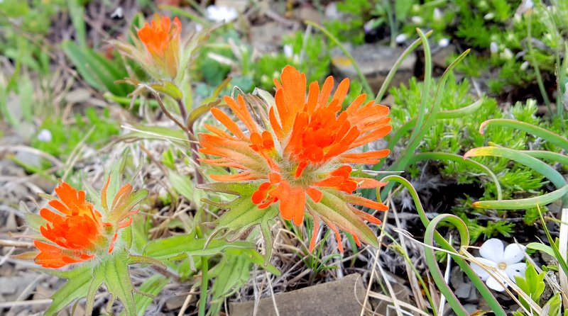
In places where the snow had melted, spring wildflowers were already taking its place.

We saw some of our first Indian Paintbrush flowers this year.
We have definitely wandered into another of God's wonders today!
We weren't visited by eagles at this altitude, but we did see a mountain bird on the top of a tree, perfectly centered and surrounded by the cloud-filled valleys.

Denisa is getting really lucky with birds that are willing to pose on clear perches today.

We stayed at the top of the mountain for an hour, reveling in the beauty of God's creation. We love the mountains, and it has been a while since we have gotten to hike among the peaks.

Later in the summer this will be an easy hike. By driving to the parking lot at the top, it would only be a half-mile up-hill hike to be here. But that also means it will be crowded. We'll take a little extra effort to get our private view today. To get an idea of just how big this view is, that tiny dot in the center of the picture is Denisa standing beside the snow drift.

We finally made ourselves take the hike back down the mountain, and back down the road to our car. Denisa is feeling sorry for the young trees, whose tops have been weighted down by the first heavy snows of the fall. They have been curved under the snow banks all winter, and Denisa wants to shovel them out so they can straighten once again.

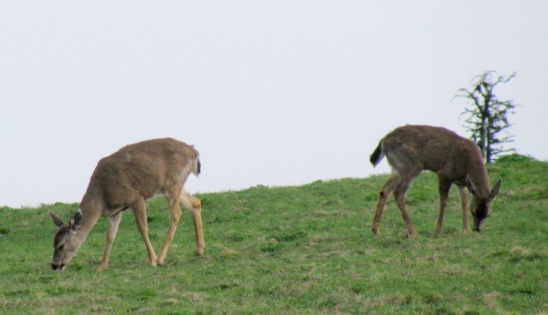
The clouds had cleared a little more, and the view from the visitor center was a little better now.

It also included a herd of black-tail deer that have grazed their way into the valley right below the visitor center.
As we drove back down into the town of Port Angeles, we found our motel room and some supper. It's been a great first day of our road trip, but we are tired. We've driven 221 miles in the car, and hiked almost 8 miles. We hope we get a good night's sleep because we have another day on this beautiful peninsula to tackle tomorrow.
No comments:
Post a Comment