
We were hiking towards the South Colony Lakes this morning, when we met a group of hikers coming down off the trail. We like to ask other hikers about their experience on the trail, and he told us, "It's the most beautiful place in Colorado!" with a starry-eyed gleam that made us hike upward even faster.
But that's telling the end of the story at the beginning of the blog, so after that teaser we must start at the beginning. We were really looking for a shorter hike since another of those daily afternoon thunderstorms was predicted. We had a forest ranger brochure that gave the distances to different mountain lakes from their nearest trailheads. When we found South Colony Lakes was only 1.3 miles from the trailhead, we thought it would be a great 2.6 mile round-trip hike for a potentially rainy day.
But then we found out that two-wheel-drive vehicles couldn't make it to the trailhead. Instead, we would have to park our car 2.5 miles further down the road. That now makes it a 7.6 mile hike. That's not too bad for experienced hikers like the Engelmans, and we are fresh this morning and ready for a good hike to those mountains now hidden by clouds.

Could we have driven our little Honda CRV down the four-wheel-drive road and avoided that extra five miles of walking? Absolutely not! We found sections with big rocks and even bigger holes. There were lines on the rocks where the underside of vehicles had scraped. We saw car parts littered over the worst sections. Mark could just imagine Denisa screaming all the way if he would have tried to drive our car up that road.

So instead of driving, we walked those 2.5 miles (uphill!) and enjoyed the solitude of nature instead of Denisa's screaming. We were joined by a pair of yellow birds that finally sat still long enough for a picture. On the bright side, we wouldn't have seen them if we were driving by.

Once we got to the trailhead, we joined the hard-core hikers with their four-wheel drive vehicles. Actually, we saw only a few people on the entire trail today. But the ones we talked to were very excited about this hike. So we plodded along, hemmed in by pine trees on this "short hike." The spring snow melt had filled the creek, and there was even water running through most of the rocky trail as well. It was hard to keep our feet dry as we jumped from rock to rock.

Three hours into the hike, we finally see a glimpse of the majestic mountains we have been climbing towards. But even from the four-wheel-drive trailhead, we have obviously hiked much further than the 1.3 miles that the ranger brochure promised.

We get to a Y in the trail, hike further and finally come to this sign. After hiking for 4 hours, we are still further from the lakes than the brochure promised. I think we have been tricked into taking this hike! The local marmot promptly stood up on his back legs and laughed at us.

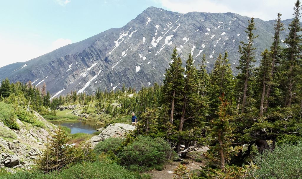
But the mountain valley that we were stepping into was absolutely lovely. We had hiked to almost 11,680 feet by now, and Crestone Mountain was looming over our shoulder. Crestone is the second highest mountain in the Sangre de Cristo Mountains, looming over us at 14,294 feet.

You can barely see Denisa standing in the snow in the bottom left corner in the picture below. Most of the time it was easier to walk on the snow rather than the muddy ground that was saturated with snow melt. In this picture we can now see Crestone Peak, but also pointy Crestone Needle as well.

Walling off the third side of the valley was another 14,000+ peak--Humboldt Mountain.

Mark took a panorama shot that include the trifecta--all three fourteeners in one picture. It was absolutely breath-taking to be standing in that valley.

Just to prove that Mark was also there, Denisa borrowed his cell phone to take a picture. It seems that the batteries on her camera were down. We hadn't planned very well for this "short hike". We didn't check camera batteries, and we didn't pack a lunch. We were just glad that the water bladders in our back packs were full when we started.

There was one thing that kept this gorgeous mountain valley from being complete paradise. All this moisture has led to a healthy crop of mosquitoes that were buzzing us from all directions. We were prepared with a good coating of bug spray, but they would still do fly-bys in front of the camera lens. That flying object that looks like a bird in the center of the next picture is actually a mosquito that is about the size of a bird.

Our hiking has obviously slowed with all the the picture-taking and jaw-dropping. We are now five hours into the hike and we finally found the lower Colony Lake that was our original destination for the day.

There was a roaring creek that connected this Lower Colony Lake to the Upper Lake. We had to cross that swollen creek and there was no bridge. Our shoes were already wet from the snow, but they were now soaked from the creek crossing.
But the view of the Upper Colony Lake sitting under Crestone Needle was worth having wet feet. This really might be the most beautiful place in the beautiful state of Colorado.

Some times we just had to stop and stare as we witnessed another one of God's wonders on this epic hike.

We are now preferring to hike in the snow, because the trail looks like a muddy little river that is running higher than our shoe tops. Between the mosquitoes and the mud the fun meter is going down once we leave the jaw-dropping beautiful section. We will hike the last 7 miles with saturated socks and hiking shoes.

Now six hours into our hike, we are leaving that majestic valley behind, to start our descent back to our car many miles away. Just as the weatherman has promised, the clouds are building, and it feels like it could rain any time. In fact, the breeze was so cool it felt like we were hiking with the air-conditioner on.

Returning the way we came can make for a boring downhill hike home. We had noticed mountain sheep prints in the mud earlier, and we were rewarded with a peek of a small herd scrambling up the rocks. The little ones were losing their winter coats, and were having a hard time keeping up with the adults.

We would later find out that four-wheelers used to be allowed to drive up to the area where we saw the 1.5 mile sign. So perhaps the ranger brochure just needs to be updated. All we know is that we hiked 13.5 mile to see the South Colony Lakes today. But it was such a beautiful place that we were really glad we made the hike. We were prepared to hike back in the pouring rain, but those clouds just continued to build instead. We got back to our car, and within two minutes the downpour started. Once again we were blessed with a dry hike.


No comments:
Post a Comment