Mark arrived in Oklahoma City late at night, glad that our son Blake lives there and able to pick him up at the airport. Mark is staying at Blake's apartment at night, but hanging out at the hospital all day. After three units of blood and a new pacemaker, his Father is feeling better. But there is more testing to find out why he was so anemic. Denisa is glad that Mark is there with family, but really missing him in Utah!
We enjoy staying in small towns and state parks most of the time. But a little dose of urban camping seemed a good option when Denisa's Mother was coming for a visit. It would provide a sizable airport that turned into a good thing for Mark to fly back to Oklahoma as well. It would also allow us to visit another cousin, and Denisa and her Mother started our tour of the Salt Lake area right at his house. Craig literally has the Jordan River Temple in his back yard, as the steeple can be seen to the left of the eve of his house.
We also got a tour of the beautiful furniture store where he works. Owned by Warren Buffett, he spared no expense with the building or the inventory. It was a nice place to bring out the cameras since Denisa's Mother loves to take family photos.
The weather didn't cooperate very well with our plans to explore the area, but we took off on a scenic drive called the Alpine Loop in spite of the clouds covering the mountain tops.
As we looped higher on the mountain road, we saw more evidence that fall is on its way. We saw groups of trees already turning orange and red, and whole groves of aspen that were golden. Later, Denisa heard a meteorologist reminding us that trees turn colors based on the smaller amount of sunlight they receive during the shorter days of autumn. The smoke from the forest fires in the northwest has plagued this area for the last weeks has artificially reduced the amount of sunlight, triggering the early leaf-color change this year.
Through our rain-spotted car windows we could see the tops of the Wasatch Mountains that line the eastern side of the Salt Lake valley. As we kept looping higher we got to the summit of one of those mountains.
But the star of the show in this area is Mount Timpanogos. Even shrouded in clouds, we could see most of its 11,752-foot grandeur. Denisa still has a hard time pronouncing the name of this mountain, so she likes to use the local's name for it--The Timp.
After lunch, Denisa had the crazy idea that one should actually visit the lake that this city is named for. Not really a destination for most tourists, we found that Craig hadn't seen the Great Salt Lake since he moved here seven years ago. The Great Salt Lake is 75 miles long, and is the biggest natural lake west of the Great Lakes. So we drove through a rain storm that could only be described as a deluge, to get all the way to the northern sections of the metro area. More than once we thought about turning back, thinking that once we got there we wouldn't be able to see the lake for all the rain.
But we were blessed with clear skies as we turned west over the Davis County Causeway towards the entry of an island surrounded by the Great Salt Lake. You can see the gray ribbon of the causeway road, with the lake on both sides, in the picture below.
Antelope Island is one of 17 islands within the lake, and is a state park. Denisa had read it was one of the best places to experience the Great Salt Lake. Fifteen miles long, this island looks pretty big on the map, and it was a good way to see the lake from several directions. It was also good to visit here to make use of that Utah state park pass that we bought.
The Great Salt Lake hosts thousands of birds throughout the year, and many more thousands that land temporarily on their migration journey. Those tiny specks in the picture below are some of the many birds we saw. These birds may not know that this lake is too salty for fish to live in. But they do know that this salty water is thick with tiny brine shrimp that can fatten a visiting bird up for the long trip home. Those tiny brine shrimp are also the cause of the sulpher-like smell we were experiencing. Craig explained that all of the city "enjoys" that smell when the wind and the conditions are right (or wrong).
Denisa's Mother coaxed Craig into posing on a rock for the next picture. He is obviously pointing out that because of the drought conditions plaguing the west, the volume of the water in the lake is down right now. So the beach is wider than it once was, making the walk to the water longer.
But no trip to the Great Salt Lake would be complete without touching the water. So Craig and Denisa made that quarter-mile hike through deep sand to get to the water's edge. We found the water to be very clear and cool to the touch. We also found that there were plentiful brine flies around the water's edge. There were half a dozen people bobbing in the salty water, but we didn't bring our swim suits. There is so much salt that it is impossible to sink in this lake, and it becomes more salty when the lake level is low. So while it is usually 4-5 times saltier than the ocean, on drought years it can be 6-8 times saltier.
Besides the lake, another attraction of this island is the bison herd that has grown to 600 in number. It was only a short drive down the road before we started seeing these huge mammals lumbering towards the lake shore.
Since we could only get back-side pictures of those bison leaving our area, Denisa had to include another picture of a lone bison lying in the prairie. There is a round-up every October, and the herd will be thinned to keep the number manageable for the island. We're not saying what happens to the excess bison, but we do know that there is a single restaurant on this island that specializes in bison burgers.
After exploring the state park, we drove back to the "mainland." Because traffic on I-15 is heavy during any time of the day, and ridiculous during rush hour, we opted for a stop for tea and appetizers.
Later as we drove back towards our homes in the southern part of the metro area, we passed downtown Salt Lake City. The state capitol is on the hill, and visible from the interstate. The clouds that brought the rain today are laying on top of the Wasatch Mountains now. The city was excited about the rain, as it helped to wash away the smoke from the air that has hidden that view of the mountains for the last weeks.
We dropped Craig off at his house, where the setting sun was bringing pink to the sky behind the temple steeple in his back yard. It was a great day of exploring, and we appreciate him using his day off to entertain two gray-haired women. It was interesting that we went places that he had never been since he moved to this city.
We had fun visiting all day long. We talked about all those summers when the
cousins stayed at our grandparents' house for extended fun. Through our
grandparents we got to experience the old-fashioned way to make sausage,
gather eggs, milk cows, make noodles, drink cold water from the tin cup at the well house, can fruit, grow gardens, etc. After
comparing notes today, we discovered that Grandma used that excess
energy of the boy cousins to make butter with a plunger churn that took
more time and work. But Denisa only remembers making butter with the easier hand-turned Dazey churn. Today was a good time of remembering old memories, as well as making new
memories.
Our life has been complicated for the last few days, as we worry about Mark's Father, Clarence. We have been searching for the best way for Mark to get to Oklahoma City, where his Father is in the hospital. It seems that the best airport for him to use is four hours north of Moab in Salt Lake City. So even though we have some misgivings about driving the motor home four more hours away from Oklahoma, we decided that would be best.
We had planned to visit Salt Lake City, so weeks ago Denisa's Mother had purchased a plane ticket to spend some time with us on the road. We had been looking forward to her visit for a long time, and so continuing to Salt Lake would allow that to happen.
One problem with this plan is that the only campground where we can get reservations is very busy. They can only promise us a spot for 7 days. If Mark needs to stay longer, Denisa will have to find a new place to camp and drive the motor home wherever that might be. That involves taking up camp, hooking up the car, navigating and driving at the same time, and setting up everything at the new place. That's something that neither of us has ever done alone, but Denisa is sure more confident in Mark's abilities rather than her own. This is a team sport for a reason, and losing half the team is tough.
So we leave the colorful red rocks of Moab, and Denisa drives the motor home a little just to freshen her driving skills. We realize we are in a white sand desert at 4500 feet in elevation, and comment that it looked like we had landed on the moon. It's sad when the only thing green in a picture is the mile marker sign. It's desolate just north of Moab!
As we continue, we climb up to 7400 feet, and we notice that the sagebrush makes the hills look lush in comparison. We're not sure if the words "lush" and "sagebrush" has ever appeared in the same sentence. We had planned to stay in a campground here in the mountains, but today we'll hurry on by because Mark has a plane to catch.
Miles further, as we get close to Mapleton, Utah, we assume that many of these trees are maples. We're shocked to see that some of them are turning orange and red. It looks like fall is already beginning to show here.
Just a few miles before we get on I-15 we see the wildlife for the day--a herd of wind turbines. We know that this means we are going through windy country, and it reminds us of the turbines back in windy Western Oklahoma.
There is road construction up and down the interstate and Mark gets practice dodging the orange barrels that have inched their way closer into our narrow lane. Denisa is trying to stay calm, knowing that she will get to dodge those same barrels if she has to drive the motor home to a new location. The motor home GPS alerts of two accidents on I-15 ahead, something that we have never seen in the last seven months of using this GPS. That makes Denisa's confidence meter go down another notch.
Denisa sets up camp in our new spot at Mountain Shadows campground, because she needs the practice. She sometimes helps with the outside chores, but her main duty involves setting up things inside. She unhooks the car from the motor home. Then she gets some fast tutoring about all things sewer, water and electrical, and it looks like she is home for a week.
Then it's time to zip onto I-15 again for the trip to take Mark to the airport. Mark is experienced at tackling an unfamiliar city's traffic, but he also has Denisa manning the GPS and maps for directions. Denisa is still trying to stay calm, knowing that she will both navigate and drive in this city she's never seen--starting soon with that 20-mile drive back from the airport as rush hour nears. There will be another trip to the airport in this unfamiliar territory tomorrow evening to pick up her Mom, but in the dark just to make it more challenging.
To add to the list of challenges, Denisa soon discovers that the air-conditioners in the motor home won't work. It was a frustrating day of learning about amps, and legs, and power monitor systems, and which air-conditioner runs off which leg, and . . . To make a very long and frustrating story shorter, she finds out from the maintenance man that we're sitting at the end of the power line at this campground. When it heats up and everyone turns on their air-conditioners, there's not enough amps left to run even one of our two air-conditioners. With highs forecast in the upper 90's, it got very hot in our little metal home.
So this travel blog entry is just a reminder that there are some tough times on the road, and this has been one of them. All of this would be minor inconveniences, but we're really concerned about Mark's parents. Today Denisa is glad that she had to take that awful Texas CDL driving exam because she has some experience driving the motor home. She just hopes that Clarence will be better soon and Mark will be home so she doesn't have to use those skills driving solo!
We have been spending a lot of time on the phone and the computer, trying to figure out the best options for our changing situation. Mark's Father is in the hospital in Oklahoma City, so we are trying to find the best airport for Mark to fly there. The Moab airport no longer has commercial flights, so we will be moving soon (if we can find a place for the motorhome).
 In the meantime, we have been looking longingly at the Colorado River that flows right into Moab. Denisa is standing on the bridge over the river, and also right over the spot that makes a good take-out for a rafting trip down the Colorado.
The only problem with having just one vehicle now is that it is impossible to get yourself to a put-in spot up the river, as well as to pick yourself up at the take-out spot. We had asked questions and determined where these spots were. We had contacted rafting companies, but they would only shuttle us if we rented their equipment. We called shuttle options, but they didn't call us back. There are bike paths that we could pedal ourselves along the river, but they end just two miles down the road. So we stood at this spot trying to think outside of the box for ways to get on that river for a float.
We saw another guy was standing beside the highway with his life jacket on. We talked to him, and he was trying to hitch-hike up the road to a put-in spot thirty miles up river where he had left his boat and wife. That's an interesting idea. We didn't even talk about it, but Denisa just walked up to a nice young couple heading to their car and asked them for a ride. We're not sure why, but they instantly agreed. They were our angels of the day, shuttling us up the river! Thanks for that random act of kindness! We hope you had a great vacation in Moab!
 They dropped us off right on the boat ramp, and we started pumping up our kayak. We were sure hoping that we didn't forget to grab anything necessary out of our car, which is now ten miles away. Since this was such a spur of the moment happening, wouldn't it have been terrible to get dropped off without our pump or our paddles?
We can usually get everything assembled and pumped up in around ten minutes, and were ready for launch under those beautiful red walls that line the Colorado River.
This was a ten-mile float, and we had those red walls lining both sides of the river most of the way. We also had the blue skies and sunshine with us. That's when we realized that when we quickly grabbed everything out of our car, we forgot the sun screen. We had sun
screened arms and heads earlier, but our legs would be exposed in this
float down river.
When we had asked questions about this section of the river, we had found that it was wide and very calm. Rafters rate stretches of rivers in a class system that uses Roman numerals and goes from I to VI. We were told that this section would be rated as a class I or II. When the river is so calm that it mirrors the cliffs around it we think it might actually be a class 0.
We did more paddling than we had thought since we were floating down stream. We had some splashy sections that were fun and sent us down the river more quickly, but usually we were paddling to help the slow current move the kayak. The rock walls turned to tan as we floated closer to Moab. We could see the natural varnish finish on the steep rock cliffs that were straight ahead. We joked that God was a little messy when He did the painting in that section.
After three hours, we rounded the corner to see the bridge that Denisa was walking on earlier this morning. Our take-out spot is now visible. More importantly, our car is waiting for us thanks to our gracious shuttle ride this morning.
Even though we had not planned a stop in Moab, we ended up staying here a week! Such is the life of wanderers. We'll be on the road again, now towards Salt Lake City because it is closer to an airport. But we'll be missing these beautiful red rocks of Moab.
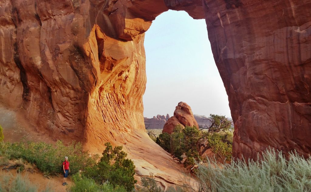
We hadn't even planned to stop at Moab because everyone knows it is too hot here in August. But after hearing great things about this area, we opted for a three day stop. Now we are waiting for news about a medical emergency at home, and thought it best to not go further down the road. That gave us time to explore another area of Arches National Park, so we set that 5:00 alarm again. The smoke in the air has brought red sunrises and sunsets, and the sun was just coming over the horizon as we neared our destination.
We were heading to the Devils Garden Trailhead at the very end of the park's road. We were surprised to see a number of cars already at the parking lot. We won't be getting the early riser award this morning, as we visited with a couple from Provo, Utah, that left home at 2:30 this morning to make this hike.
There are seven arches in this 7.2 mile hike, and of course we had to go to each one. First is the Tunnel Arch, and we were fenced in from getting any closer to it.
The second arch is the Pine Tree Arch, and we could stand right beside those pine trees that it is named after.
The rising sun is now lighting up the eastern side of the arches, so we had to take another picture from the east side of the Pine Tree arch. It's hard to recognize where the arch starts and stops from this view, as there is a large rock wall right behind it.
Those pine trees have lots of green pine cones on them, so it might be a very good year for pinyon nuts. We thought they wouldn't be opening until the fall, but Mark found this opened cone on the trail. He also harvested five pinyon nuts. He was obviously watching the raven's technique a couple days ago. But we don't remember seeing that the raven got as sticky as Mark's hands got. His hands would smell like pine-sap for the rest of the day, and holding his hand literally meant we were stuck together.
One of the most famous arches in the park is Landscape Arch. This is the longest natural arch in the world, measuring 290 feet. That is almost as long as a football field!
Now just a ribbon of rock, the path to the arch was fenced off since
large slabs of rock have fallen from its thinnest section three
different times since 1991. These were sizable slabs measuring 30, 47,
and 70 feet in length. Its a good thing to see this arch now, because
another fall like that might turn it into two landscape nubs.
The walk between arches is on a trail, but very often that trail is straight uphill on slick rock. You can see that many feet have smoothed this hill that lies between large walls of rock.
The fourth arch actually has two openings, and is called Partition Arch. We're both pictured in the top opening because some new friends from China offered to take our picture together.
Denisa is still in the upper arch, while you can see the two of them in the larger lower arch. They are visiting the United States on their honeymoon, and were very appreciative of our help with reading the map and directions between each arch.
The fifth arch, Navajo Arch, was the hardest to photograph. It was harder because there isn't room to back away from it. But it was also harder because there was a couple from Los Angeles that were going to great lengths to get the perfect shot, so they were always in our way. Note to self--don't be that obnoxious photographer that doesn't share arches well with others.
While Denisa is usually content to return to the path on the ground, Mark is always looking for an alternate path that usually includes climbing over something. True to that form, he climbed over boulders at the end of the canyon. Since he had the camera with him, he took pictures of Denisa down on the normal people trail. I guess that statement means that Mark is not a "normal people."
It was after 9:00 by the time we hiked to the Double O arch.
Again, we couldn't get very close because of the following sign that was posted nearby:
This picture clearly shows the lighter colored stone that was left on top of the smaller O after the slab of rock fell.
The last arch of the day was Private Arch. As its name would imply, we had to walk quite a ways off the loop trail to get to this arch.
We could take pictures from both sides, so of course, we did. We had private arch to ourselves, which was another great reason to start this hike early. In the course of the morning, we kept crossing paths with four other couples that started this hike about when we did. By the end of the 7 miles we felt like old friends. We use the term "old" loosely, considering that we were twice their age.
After all the arches were found, it was a long hike back to the car. There were some fun sections, however, like these rows and rows of sandstone fins standing parallel to each other.
Some of those giant fins were just asking for someone to crawl up them, so Mark (of course) will oblige.
We took the primitive trail that made the hike into a loop. Because fewer people make this loop, it was a quiet slog through some thick sand. It was on this quiet section that we met up with a team doing search and rescue with the same color shirts that Mark was wearing. They explained that a 16-year-old boy was last seen yesterday morning, so we unofficially joined them in the search for the rest of our hike. We thought about the heat and going without water in this desert for a day, and we prayed for him the rest of our walk to the car.
As we got back to the beginning of the trail, we were amazed at the mass of people starting into Devils Garden. That empty parking lot was now full. Arches National Park hosts over a million visitors each year, and most of them seemed to be on this trail this day. Most will go to only a few arches and won't take the loop because of the heat. But we were glad we got to enjoy these wonders in the cool and calm of the early morning. We have enjoyed Arches National Park, and feel so blessed to be able to live just a few miles away for this week so we could really explore it.
Our cousins, Paul and Leslie, had told us about Fisher's Towers, so we were thrilled to have the time to make the trip out to these majestic rock formations! They look something like a red rock castle on the top of a mountain, and we would soon fall in love with this hike.
We gathered information on how to get to Fisher's Towers. The brochure said it was 21 miles north of Moab on Highway 128. When we had traveled 20.6 miles, we assumed that this must be the gravel road we were looking for since there aren't many roads leading off the highway in this area. When we crossed Onion Creek in our little SUV the first time, Denisa was doubting that decision.
When we crossed Onion Creek the eighth time in our car, she insisted that we must turn around.
We went back to Highway 128, and .4 miles down the road we found the correct turn-off, even labeled "Fisher's Towers." Two miles down that gravel road (with no creek crossings), we were in the correct parking lot and already charmed by the scenery.
Every time we turned a corner, we were greeted with more beautiful rock formations. The tall spire over Denisa's head reminds us of something off the top of an ice cream cone! That curly-Q is obviously bigger than it looks, because we have seen photos on the internet of a climber standing on top of it.
We've only been hiking 20 minutes, and we know we have wandered into another of God's wonders!
These rock fins dwarf Mark standing in front of them, and these are some of the smallest of the towers.
Thirty minutes into the hike, Mark took a panorama picture of the towers on all sides of us.
 We turned another corner to see a huge monolith in front of us. We also heard a tapping, and Denisa first wondered if that huge wall of rock was creaking right before it fell on our heads. Then we realized that we weren't alone in the towers today. There were two climbers making their way to the top of the spire in front of us. Because they are too tiny to see in the scale of that rock, Mark circled the two climbers in red.
As you can tell from the circles, the climbers were quite a ways apart on their journey to the top. The top climber was actually standing on a ledge, waiting for his partner. The pictures are blurry because this distance is really stretching the abilities of our camera. We watched them through binoculars, and could see that they had taken many supplies up with them on a climb of this nature. There is a whole array of harnesses, and another pack with more supplies.
The lower climber seemed to be struggling. They spoke to each other at times, and their voices echoed through the canyon. We're not sure what they said, as it was not in English.
Just like animals entertain us, we found that we are also fascinated by climbers. We watched for a while, and the top climber decided to take a break and eat while he waited for his partner.
As much fun as it is to sit and watch climbers, we had more towers to experience. So we hiked on, stopping to take way too many pictures!
We finally made it 1.5 miles to "The Titan," the tallest of the spires in this area. At 900 feet straight up, it is also a favorite among the rock climbing community.
We kept walking, and the hike took a turn away from the towers across a mesa. We knew it was a 2.2 mile hike, but it seemed to be taking us away from this beautiful view.
We continued to follow the rock cairns across the flat mesa until we had to crawl on top of a huge boulder. Sitting on that boulder was a wooden sign that read, "Trail Ends."
Denisa has decided that she needs to carry a sign like that in her back pocket. Too many times we have taken very long hikes that we couldn't decide when to turn around. She could throw down that "trail ends" sign and know that it was time to head back to the car.
Since this was an evening hike, we got to enjoy the light from the setting sun on the rocks as we hiked back. There is still smoke in the air from the forest fires of the northwest, but The Titan was still spectacular through the haze.
Denisa was intent on getting a picture of the blue bird couple that was twittering in the trees along the trail. She has a weakness for red sandstone, green junipers and blue birds all in one picture.
Of course we had to check on the progress of the rock climbers as we passed back by that section of the hike.
They were much closer together now. The lower climber was now standing on the ledge, while his partner was continuing up the spire.
We really enjoyed this hike, but it's not for the faint-hearted. The trail is narrow and slanted at places, with drop-offs into the deep canyons.
The trail rambles up and down through the canyons. So even though there isn't a lot of elevation change from beginning to end, we still were climbing both ways. There was a ladder neatly cemented in place, to help with one particularly steep incline.
We loved this hike! At only 4.4 miles round trip, it provided great views as soon as we started. There was never a boring section, and the heights just got taller and spires more majestic as we progressed along the hike. After spending time with the crowds in the national parks for the last several days, we were glad to have this hike completely to ourselves. Aside from the climbers, and the two German hikers that were just finishing the hike as we arrived, we didn't see anyone else here. As we returned to the car the sun was starting to set on that curly-Q we spotted at the beginning of our walk. We'll remember the wonders of the Fisher Towers for a very long time!