After our four days on Long Beach Peninsula on the coast, we are heading in-land again. We're still on Highway 101, but instead of driving beside the Pacific Ocean, we are alongside the waters of Willapa Bay. Our campground is right on the Willapa River, and we are excited to have a site that is facing the water. We don't have any television signal here, so this view out the front windshield is our wide-screen source of entertainment. We watched an osprey fishing in the water. We watched a flock of geese flying overhead. We watched as the tides went from low tide that drained the water out of the bay . . .
to high tide. Notice the same post approximately in the middle of both pictures. It was definitely a muddier view from the windshield at low tide.
We watched as a flock of birds flew right over the top of our motor home in V-formation as the sun was setting. This is pretty riveting programming from our windshield view.
Besides the views of the water, we also have some pretty interesting parking lot views. We are parked behind the Prestige Boats factory. Here they build one-of-a-kind catamarans for customers that have a crazy budget for luxury.
Mark is standing in front of the two catamarans on the lot, and it's hard to describe how big they are. It takes this small company around two years to finish one of these boats. The owner showed us pictures of past projects and let us look in on the workers in the shop. It's like we are living at a factory tour!
The address of the campground is Raymond, Washington. Just like the television show, "Everybody loves Raymond." We drove into town to see the metal sculptures that are found on most of the street corners.
There are probably 100 different metal sculptures scattered around town and the surrounding grassy areas of Raymond.
Raymond also has a kayak dock, and we had beautiful weather for a trip on Willapa River.
It takes about 15 minutes to inflate our new Sea Eagle kayak. This up-graded boat is sturdier and tracks better than our old beloved Sea Eagle.
We have driven many miles on Highway 101, but today we would float under the Highway 101 bridge.
We are learning about tidal rivers, and since we are so close to Willapa Bay we are definitely seeing the effects of the tide. We studied the tide schedule and found that it was supposed to be high tide at 3:15 p.m. So we were on the water by 1:15, to take advantage of the tide's in-bound flow to push us up-river.
The Willapa River is wide, and surrounded by tall trees and grass. But there are narrower "trails" that allow kayakers to explore the inner inlets of the river.
As we went deeper inside, the trails got narrower.
Many times there were options to go multiple directions, so we had to choose which path we wanted to follow. But there are no maps and no trail signs. We wondered how easy it would be to get lost and continue to wander through this grass maze that went on and on.
We finally got to the end of our trail, and then had to remember where we turned left or right to get ourselves back out to the main body of the river. We had never played kayak maze before!
We made several trips into the grass mazes that lined the river. Denisa gets a font row seat to our kayak trips, but poor Mark gets the back seat view from the rudder position.
We continued up-river until high-tide, then we turned back towards home in hope that the changing tide would pull us back to our launch point. There are three factors at work in our kayak trip--the river current, the pull of the tide, and the wind. For all our planning around the first two, we would find that the wind would have the biggest effect on how hard we had to row today. We were making pretty good progress as long as we had the wind behind us.
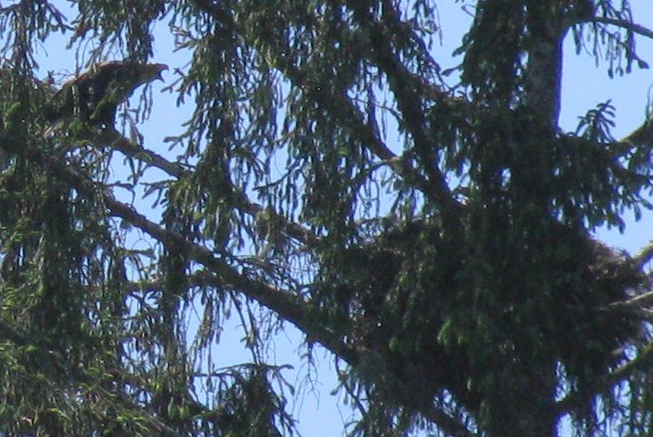
Not long after we turned around, we saw two large birds flying low over the water in front of us. We were surprised to see it was a turkey vulture being chased by a bald eagle. We got a shot of the eagle soaring overhead as the vulture left in the opposite direction.
We were wishing for a closer look at the eagle, when we saw her turn and land in the biggest tree right beside the river. We snapped this picture of the eagle, with her mouth wide open communicating to something else in the tree. That's when we noticed the large nest in the bough of that big tree.
We were lucky enough to see that two heads popped up out of the nest. Now we could understand that the vulture must have gotten too close to the eagle babies and the nest.
Once things calmed down, the parent eagle took off again. We've seen many bald eagles lately, but it's still a thrill.
We had a great time on the river, and perfect weather to be outside all afternoon. Now we know why everybody (including us) loves Raymond.
We are living in Lewis and Clark territory, and re-learning much about their trip from St. Louis all the way to the west coast. They named their group of fearless explorers the Corp of Discovery. Likewise, in our exploration of this peninsula we discovered a great bike path that is named the Discovery Trail.
Mark spent some time adjusting brakes and lubricating gears to get our bikes into better shape for a long ride. We got on the Discovery Trail and took off towards the south. It was a delightful trail that followed the ups and downs of the sand dunes that run parallel with the ocean beach.
There were stops that educated us on the Corp of Discovery's journey through this area. One day they found a dead whale on the beach, and wrote in their journals about its size and bone structure. So when the same thing happened in Long Beach 200 years later, some of the whale bones were saved to exhibit them here along the trail.
There was also a carved wooden statue of whales beside the skeleton. This is another great place to see the whale migration, but it was too cloudy for that today.
We had just mentioned what a great paved bike path this was, and at how well our bikes were performing after Mark's work on them. Then it happened. Mark saw bright green stuff shooting out of Denisa's rear tire. We knew that tire was going to give way soon. In fact, Mark has already patched it up with gorilla tape. But here we were in the middle of no where and it was losing the bright green "fix-a-flat" liquid on the trail.
It's at this point that we can start the advertisement for fix-a-flat. We rotated the obvious hole to the bottom of the tire, and allowed this gooey green slime to do its job to seal the hole. We waited a few minutes, and then we took off on our bikes again. The trail took us close to the Pacific coast at times.
We got another mile down the trail before the the bright green started spewing again. So we rotated the tire again, waited a little longer . . . and rode on.
Our destination today is Cape Disappointment State Park. We should explain the interesting name of this state park. When British Captain Meares was sailing his ship along the west coast in hopes of finding the mouth of the Columbia River, he missed it. He did find this area just off the river, so he named it Cape Disappointment. As the bike path got closer to the state park, it became more forested and more littered with pine cones and leaf litter. Denisa is weaving between the chunks on the trail, hoping not to puncture through that fragile layer of fix-a-flat.

We were not disappointed when we finally made it to Cape Disappointment! It's at this point that Denisa has a spot to park her bike, while Mark has the unenviable task of riding his bike back to get the car. We had both planned to be riding this section back to the car, but now Mark had it by himself. That's when he discovered that we had been enjoying a 5% downhill grade and the wind at our backs. So now Mark got the up-hill ride against the wind, and it started sprinkling. It looks like Denisa picked a good time to have her tire blow.
So while Mark struggled with that bike ride home, Denisa was checking out the state park. Denisa understands that feeling of Captain Meares' disappointment just a little. First her bicycle tire gave out. Then she hiked to the North Head Lighthouse, only to find that it was being repainted this spring. She took a picture of it encapsulated while it was being refurbished.
According to the nearby sign, this 66-foot lighthouse has been on this point on the Pacific coast since 1898. It's probably time it was refurbished. There was also a picture of what Denisa was supposed to be seeing.
The lighthouse keeper's house has already been refurbished, and is available as a vacation rental here at the state park.
While Mark was pedaling hard, Denisa was leisurely strolling among the wildflowers. She is fascinated by these large plants with fist-sized bundles on tall stems.
When the bundle is ripe, is suddenly bursts open to reveal hundreds of blooms inside.
That's an interesting process to bring the large bloom of the cow parsnip out in the open.
Mark showed up with the car so we could load up Denisa's limping bike. This is actually a Walmart bike that we purchased around fifteen years ago when our youngest son was in grade school. We had decided that when that back tire blew, it was probably time to replace the bike. But it was performing so well after Mark's work on it that Denisa is having second thoughts about getting a new one. It's hard on a bike to be subjected to the road grime and weather every day. Besides, she's ridden a lot of miles on that bike!
We finished our exploration of Cape Disappointment State Park in the car, so we got to use our Washington state Discovery Pass again. We parked next to the trail for the other lighthouse in this park. This coastline is so treacherous that it required two beacons to guide the ships. This is the Cape Disappointment Lighthouse. We hiked a steep trail to get to its lovely setting on top of the head. Based on the peeling paint, it looks like this guy might be next in line for refurbishment.
It was built here to provide guidance around the treacherous Columbia River bar, known as the "graveyard of the Pacific."
Commissioned in 1856, it is still a working lighthouse. Just steps away is a coastguard station that is providing more modern services of weather and water monitoring for the area.
On our way down that steep trail, we decided to take the even steeper and muddier trail all the way down to the protected beach at the foot of the lighthouse.
This narrow cove was a beautiful place to be on a windy day that had been threatening rain. The tall rock walls around us are sheltering us from the wind, and there's a tiny sliver of blue in the sky above us.
Another walk uphill took us to the rock wall that houses the park's interpretive center. That is where the Lewis and Clark Discovery Corp stood to see the Pacific Ocean back in 1805.
Their trip to this cape lookout was their most westerly point of travel on their discovery mission. It's a beautiful view from there over those yellow wildflowers.
So even though our bicycle trip didn't turn out the way we had planned, we still had a great time exploring Cape Disappointment State Park. Now we have to figure out our options for battling the disappointment of being bike-less.
We had a great time exploring most of the Oregon coast earlier. When we traveled inland to visit a couple other parts of this beautiful state, it suddenly felt like our journey through Oregon was unfinished. So as we camped in southern Washington, we planned a day to "finish" the north coast of Oregon. We planned a day to visit a combination of Lewis and Clark sites, and beautiful beaches.
We started the morning at the "Dismal Nitch." That's a horrible name for a place that looks beautiful to us this morning. But when Lewis and Clark, and their group of explorers (named the Corp of Discovery) faced days of torrential storms here in 1805, that's the name they gave their campground overlooking the Columbia River. As we pulled into the parking lot, we saw an eagle soaring overhead. Even at the Dismal Nitch, it's going to be a great day!
We crossed over the 4-mile Astoria Bridge that you see in the background in the picture below. That brings us to Oregon's northern-most coastal city. Mark is standing on Astoria's River Front Trail that follows our old friend--the Columbia River--for a mile and a half.
We are also seeing that this river can be a transportation hub. There are a group of sizable cargo ships lined up on the Columbia. Perhaps one of them is the load of timber we saw being loaded at the Longview Harbor.
Astoria is one of the oldest cities in the west. We drove up the steep streets to get to Coxcomb Hill and the column that depicts that long history in a unique way.
The Astoria column is 125 feet tall, and includes a hand-painted depiction of scenes from this city's history. Of course, our friends Lewis and Clark are included on the tower.
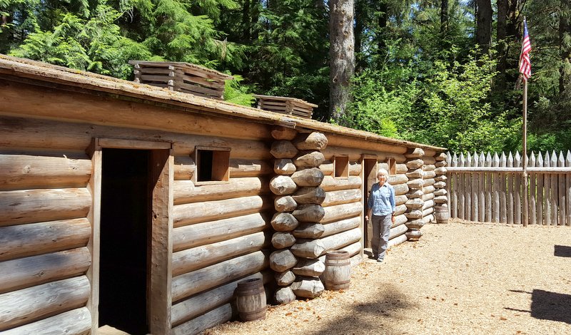
We next stopped at another important Lewis and Clark point of interest. Fort Clatsop was built by the Corp of Discovery as a place to live through the winter of 1806. The group lived here for four months as they prepared for their trip back home in the spring.
The original fort has been gone for years. But this new fort used Clark's blueprints for the reconstruction.
We wandered through the forest and rivers where they hunted and fished during that winter. Since then this river has been used to transport logs to the Columbia River. The wood stumps in the water ahead were used as lanes to gather the cut timber for lashing it together to be moved downstream. We also have to point out the beautiful blue sky and the perfect temperatures we are enjoying this day.
Our next stop is the Fort Stevens State Park, most famous for the beach that has housed the rusty wreckage of a ship known as the Peter Iredale.
The Peter Iredale ran aground on this beach over 100 years ago, testament of the rough waters near the mouth of the Columbia River.
Our next stop is the little coastal city of Seaview, Oregon. Even though some of the letters of "OREGON" are wearing away, this sand sculpture still deserved a picture with the ocean in the background.
Have we mentioned that the weather today is ideal, with lots of blue sky and no wind? We started the morning in hiking pants. But it was the first day in a very long time that we have needed to zip off the legs to transform them into shorts. This was also the most people we have seen on a beach in a long time.
Seaview is a family-friendly resort town. The narrow main drag is lined with touristy shops, candy stores, arcades, bumper cars, a carousel, ice cream parlors, and restaurants . . . everything to keep all the members of a family happy between time at the beach.
We had read about Seaview's "Historic Car Turnaround" and didn't know what that meant. So of course, we had to drive the car to turnaround there.
The center of the turnaround is a statue of the town's most famous visitors--Lewis and Clark.
In keeping with our historical theme (and because the weather was so beautiful), we walked the half-mile down the promenade to the "Salt Works." During the winter of 1806 when most of Lewis and Clark's Discovery Corp was holed up at Fort Clatsop, a small group was hanging out on this beach. Here they were stoking the fire under the rocks 24-hours-per day to keep those pots of salt water boiling. They were boiling away the water to leave the salt for flavoring and drying foods for the trip back home in the spring.
After eating a fine lunch at Seaview, we headed a little further down the road to the town of Cannon Beach. Its iconic beach features "Haystack Rock" on the right, and "The Needles" on the left. Isn't it really hard to find Denisa between a needle and a haystack?
Haystack Rock is 235 feet tall, and it makes one feel very small when you get close. Again, you might not be able to recognize Denisa standing in the very cold surf on the left. Her toes are going numb as she waits patiently for Mark to take the picture.
We purposefully came during low tide, when the tide pools at the base are out of the water. There were lots of other people at the beach with the same idea today.
We didn't take any tide pool pictures this time, but the one picture we really wanted were of the tufted puffins that nest in burrows on the haystack. Haystack rock is the best chance to see the puffins. No close encounters, but we did see some flying in the air.
We have certainly been blessed with a roll-your-pant-legs-up kind of day to explore Oregon's north coast.
Our last stop of the day was Ecola State Park. As we look out over the coastline, we can see Haystack Rock far away in the background. We heard so many good things about the beauty of Oregon's coast, and we have to agree. We feel like we have once again wandered into another of God's wonders.
From the other viewpoint at the state park, we can get a look at the Tillamook Rock Lighthouse. Being on an island that is over a mile from the shore, it's not accessible to the public.
But if she zooms in with the camera, Denisa can get a hazy view of "Terrible Tilly"--the 9th and final lighthouse on the Oregon coast. We got to see every one of them! It feels like we have conquered this beautiful coast now, and we were blessed with a wonderful weather day to enjoy it.
This is really our last day in Oregon, and we have to say it is one of our favorite states so far. It certainly has more than its share of God's wonders to wander!