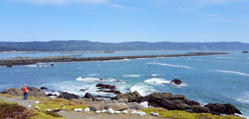
We are sitting at the north edge of California,
looking longingly into Oregon. Who knew that there were so many great places in California that it would take us two months to wander through a single state? When we left Oklahoma in the autumn, we said our
destination was the Pacific Northwest, and that meant Washington and Oregon to
us. So five months later we are almost there! We have heard so many good things
about the Oregon coast, so we have decided to stay on Highway 101 that hugs the
coastline. But we saw that Oregon's only national park was 3.5 hours east of
that coast. How were we going to see both?
So we made an executive decision to make that
drive to Crater National Park in a day trip. It might be crazy, but we got in the
car around 8:00 in the morning and set the GPS. It will take almost 4 hours to
get there, but it looked like it was going to be a good traveling day. We drove from our place at the beach,
and headed into the mountains on winding roads. As we got to higher elevations, we began to
see snow beside the road.

The snow banks got taller until they were easily
taller than the car. It's a good thing we dressed warmly today!

Driving straight through, we got to the visitor center before noon. It was interesting to see that all the buildings are embedded in drifts of snow.

But we were excited about the sunshine today, because
we had read that sometimes the view of the lake can be completely shrouded in clouds. We were blessed with
clear skies for our first view of Crater Lake.

It might be crazy to drive 379 miles today to see
a single attraction, but we think this view was worth it. We have definitely wandered into another of God's wonders today! At 1,946 feet deep, it's the 9th deepest lake in the world, and the deepest in the United States.
Crater Lake was formed 7700 years ago when Mount Mazama turned into Volcano Mazama and blew her top. The magma inside spewed rocks hundreds of miles away, and the sides of the mountain collapsed. That formed a round water-tight bowl that started collecting water. It was surprisingly cold on the rim of that caldera today.
Between the snow and the breeze, we were glad to have our biggest coats and gloves with us this afternoon.

This area obviously gets plenty of moisture in
the form of rain and snow that started to fill up that new bowl. They average
45 feet of snow each year, and much of that melts and drains into the lake. Unlike other lakes, this new bowl didn't have
any rivers or streams flowing into it. That means it also doesn't have any
river sediment like other lakes. So that is why Crater Lake is perfectly clear
and beautifully blue.
When we asked the ranger about possible hikes, he
gave us the usual once-over to determine our durability. He recommended that we
rent snow shoes, that would enable us to walk a couple miles to overlooks over
the lake. He mentioned that going without snow shoes would be very difficult.
He added that some times college kids try "post holing" it around the
lake, but that wouldn't be his idea of having fun. The snow is very packed at the first overlook
where everyone takes their mandatory picture. But the further away from the
traffic, the less packed the snow. We could understand what "post holing" meant as our feet would randomly go through the snow up to our knee. Here is Mark in his best post hole pose, standing with snow up to his knees.
Walking on the snow was a bit like playing Russian roulette, as we never knew what step would stay on the surface, and what step would sink deep
into the snow. But we must be like a couple of crazy college kids, because we
got to hike as far as we wanted without renting snow shoes. This picture shows that Mark walked to the edge
of the volcano cauldron as far as anyone had since the last good snow fall. There
are no foot steps in the snow behind him.

Denisa took this picture from the side. That's when we found out that the swell of snow Mark had been standing on didn't have much support from the bottom before it dropped down into the cauldron.
We have to admit that most of the people that ventured this far had on snow shoes or cross country skis. We talked to these two girls on skis with the heavy packs. They had spent the night in tents on the other side of the lake. They reported that the night was cold, but the stars were glorious.

We also took pictures with a snow man that hikers had made earlier today.

As you can tell from the next picture, it really wasn't a very big snowman!

As we walked back towards the visitor center, we
decided to build a full-scale snowman. Maybe we should rephrase that: Denisa
decided to build a snowman. The interesting part of that decision is that Mark
did most of the work in this construction project.
We didn't have any branches for arms, and there
weren't any laying around on top of all that snow. So we had to improvise with
the arms.

We even got some shots of an extra tall snowman
that looked very familiar.

We gave our snowman some facial features before we left him to brave the cold on his own.

We were also totally impressed with the mounds of snow
in the parking areas. The usual angled parking spaces are covered with snow, so cars are now parking in a straight line on the center line of the park road.

The snow drifts are close to twenty feet tall around the national park. By this time of year, most mounded snow is dirty and grimy. But the snow in the national park was all sparkling white from top to bottom.
The three-story visitor center has snow covering
the first two floors, and bathrooms in the parking lot are buried in a snow
drift.

It got cloudier and windier while we were
enjoying the views of the lake. We feel very blessed that we got the views of
the United States's deepest lake on this road trip! The weather forecast predicted 18 additional inches of snow over the next two days, so we definitely got here on the clearest day possible.

We also watched the 20-minute national park film and
checked out the gift shop. After several hours, we were ready to head back
towards our home on the coast. But we had read about a couple hikes to break up
our trip home. The first is a hike to the "Vanishing River." Mount Mazama wasn't the only volcano in Oregon,
because there is an old lava tube that runs under this forest. It's going to
take some imagination to picture what this river looks like in the summer.
Under normal river flow, the river disappears into that lava tube underground and
is completely hidden from view for about 200
feet.

Then the river flows out of the end of the
natural lava tube, and continues its flow--just like it had vanished. Here is the picture at the trail head that pictures what we were supposed to see.

But today, the river is so swollen with snow melt
and spring rains that there is too much river to fit into the lava tube. So
there is still continuous water in the riverbed. We could still see where the
water was rolling out of the underground lava tube, but the magical vanishing river today was not performing its magic trick as convincingly as it will later this summer.

This one-mile hike turned much longer because the
road was closed at the highway because of snow. So we got some extra exercise walking through
the snow on the forest service road today. After walking gingerly through these sections of snow at first, we came up with a more efficient way to move through the snow. We held hands for more stability, and then ran through the large sections of snow. So much easier and steadier than walking! That got our hearts pumping!
We still had daylight, so we could make another
stop at the town of Prospect, Oregon. The Rogue River is also swollen, and we knew
the waterfalls in that area would be spectacular. We hiked out to see the Barr Creek Falls,
which drops 240 feet from the side of that mountain.

It's a short hike to also see Mill Creek Falls, with an
impressive 175 foot drop.

We also got to see the Avenue of the Boulders. These large boulders were part of the debris that flew when Mount Mazama exploded over 20 miles away. Mark is actually standing on a cliff high above these motor-home-sized boulders in the picture below.

We made a stop for a meal and some groceries as we drove through the city of Grant's Pass. The sun was setting as Mark drove the long final push back home to the coast. He had driven 379 miles and was behind the wheel almost 8 hours today. But we got
to wander around more of God's wonders today. We thought the road trip was worth
the incredibly blue views of Crater Lake!
We left our camping spot in Eureka, California, and we're once again heading north up Highway 101. We have been close to the coast for a while, but we are still surprised when we catch another glimpse of the ocean. When you were raised in a land-locked state, it was a big deal to visit the ocean. Now we're living where it seems to show up around every curve in the road.
Some of those curves have had a rough winter. There is much road work being done along Highway 101, making the drive a little challenging. This section of one-lane traffic features the side of the mountain to our right, and a cement barricade on the left. There is no where to detour traffic, since that is a drop-off down to the ocean on the other side of that construction truck.
We are headed to the tiny town of Smith River, California. If you google "Smith River" you will see that it is the cleanest river in the lower 48 states. This emerald green river is un-dammed for its entire stretch through the mountains, and we were told that it's the holy cradle for wildlife because of its pristine water quality.
We have two sight-seeing missions while we are staying here. One is to the nearby Jedediah Smith State Park. From our spot in Smith River, it's a dirt road drive from the ocean into the mountains.
For those that don't hike, driving this road is the next best thing to hiking through the ancient redwoods. There were many times when we could stick our arms out our car windows and both touch a redwood at the same time. This is the narrowest dirt road we have seen, so some of the magic is lost in wondering what your options will be if a car comes around that blind curve going the opposite direction.
The good news is that not many people will attempt this muddy road filled with pot holes, so we met only a few in our drive up the mountain. We both laughed (nervously) when we passed the "road narrows" sign and wondered how it could get any more narrow. We pulled into the small parking lot for the Stout Grove trail head with a few other hardy hikers, and headed down the trail. You should know the redwood hike drill by now--look for one of us standing at the base of the tree to give some scale to the majesty of these 300-foot-tall trees.

We are here because of several different recommendations from fellow travelers we have met along the way. The first was while looking at California poppies at Antelope Valley. A young guy that had just returned from photographing the fjords of Norway, told us that this was his favorite place in the entire world. He gave us directions down that muddy road, even though he claimed he didn't often share this location with others. So of course we had to come here!

We love these hikes among the old-growth redwoods that are the tallest living things in the world. No fences, no crowds--our favorite kind of trail. Again, these trees were saved from the logging of early settlers to the west coast because of that terrible road we just drove. There was no way to get that lumber down to the people wanting to build houses in the valley. So they were saved until conservationists could rescue them for us to enjoy today. Of the bounteous forests of redwoods that once stood proudly on this coast, 95% were cut down for their lumber. The remaining 5% are only left because a group of concerned citizens raised the money to purchase those forests away from the logging companies.
In between all those trees are lovely spots of green competing for the limited sunlight streaming through the redwood canopy. The ferns are now unfurling their new spring fronds.
We thought that the redwood trees would be like the Sequoias we saw in central California--confined to just one or two parks. But as you can tell from so many blog entries with Redwoods, they stretch from San Francisco all the way to southern Oregon. So there are many places to see giant redwoods. But Stout Grove is one of our favorite places of them all.
We have learned much about these redwoods as we have wandered through so many forests. For example, they can live for 2,000 years. But they grow to most of their soaring height in the first 100 years. Once they reach the forest canopy, they only grow a few inches per year in height. At that point, they use their energy to making their core bigger around. This ancient redwood forest is tucked along that beautiful blue Smith River that is running beside us now.
As we walked back out of the Stout Grove, we found that our hiking trail became a wide and paved sloping path. We laughed to think that this trail was wider and in much better shape than the road we had driven to get here.
We made the drive back out of the forest to return to the coast. We were just in time for low tide--the perfect time to visit Battery Point Light House. Built on an islet outside of Crescent City, the walk to the light house is under water during high tide. But for now we could walk across the rocky isthmus with dry feet.
This little lighthouse was built in 1856, and remained in service until 1965. After a short "vacation," it was reactivated as a private aid by the local historical society.
So it is still a working lighthouse, and the lighthouse keeper's residence is still in use today.
That keeper of the light has a beautiful view north up the coast . . .
as well as to the south to the jetties of Crescent City.
After some nice blue-sky days, we see that there is a ring around the sun. We don't know what that means on the coast, but in the midwest a ring around the moon means storms are coming. We couldn't stand to look at the ring with our bare eyes, so this picture was taken through Mark's polarized sun glasses.
We decided to take advantage of the low tides to see what the Crescent City beach tide pools were hiding. These rocks are usually covered in water, but right now we could walk out on them.
Tide pooling is like looking down into one of those expensive salt water aquariums. You never know what has been trapped in the clear water of these rock crevices as the tide receded.
As you can tell from the picture above, one of the fun things to find can be a sea star.
Because they are alive and moving, they often don't look like perfectly spaced five-pointed stars. They can be draped across the rock surfaces in odd shapes in the tide pools.
This was a really odd-shaped sea star. At one time he was quite comfortable while he was surrounded by ocean water, clinging to the rocky surface. Now, not so much.
We got a side-ways view of this guy, including the tiny suction cups on his underside that holds him in place.
We also found this good-sized anemone, with only a few tentacles sticking out in this shallow water pool.
There were hermit crabs and and snails clinging onto rocky surfaces, as well as this curious marine life. It took Mark some serious googling time to find that this is a haliclona permollis. The scientific name seems a little formal, so we prefer its more common name--purple encrusted sponge.
The pastels must be the preferred sea color, as we saw pink in other lacy rock coverings under the water today.
Buying a ticket to a nice aquarium along the coast is a good way to learn about the ocean. But we much prefer discovering the marine life in nature right at our feet.
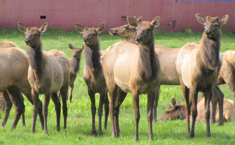
As we made our way back to where our motor home is parked in the town of Smith River, we had to stop to see the big herd of elk that were congregating close to the ocean.
There's a grassy meadow near a beached ship that made an interesting back drop to this beautiful herd.
They were all standing at attention as we drove by. The sight that has peaked all of their interest--a couple helping their child on one of her maiden bicycle rides down the neighborhood street.
Smith River's city sign touts it as the "Easter Lily Capitol of the World." We drove down back roads looking for lilies. Perhaps they have just recently been harvested to be shipped around the country for Easter, because we didn't find any in the fields. We did find Tolowa Dunes State Park, where we took a walk along the beach. We saw three guys with fishing poles, and so we walked closer.
We were sure wishing to see one of them catch a fish, and it wasn't long before we got our wish.
When he saw our camera, he even turned around to show off his catch.
We have gotten pretty good at starting conversations with complete strangers. That is made easier when you ask people about something they really like to do--like fishing in the ocean. We got lots of interesting information from a guy that has been fishing here for most of his life.
For bait, he uses the sand crabs that are readily available right below the surface of the sand. They are about the size of a quarter, and are easily placed on the hook. The tides were just right for schools of red-tailed surf perch to be coming in close to shore to feed. He was getting a bite within ten seconds every time he threw out a new line.
It took a mighty yank to set the hook, and it's a good idea to be wearing something you don't mind getting wet. That's because it's too hard to watch a fishing pole and the waves at the same time.
As he walked another fish to his bucket on the beach, he offered us his pole so we could try it. Denisa has been kicking herself ever since for not taking him up on his offer.
There were times when we saw all three fishermen with fish on the line at the same time. That was a sizable school of hungry perch just waiting to be caught. He would easily catch his limit as his bucket got fuller while we were watching.
It's hard for us to get used to the diverse geography that Californians enjoy. As we walked back to our car at the beach, we could look straight east to see mountains with snow on them. That's a picture of just how close the ocean is to the high peaks in this state.
Our last stop of this fun-filled-day was the beach just a half-mile from where we are staying. Since we knew we would be sight-seeing most of the time, we are boondocking in the parking lot of the local casino in Smith River. We are very close to the estuary where the Smith River meets the ocean. In the picture below, we see the mouth of the river to the left, and the waves of the ocean on the right.
We noticed rows of seals on the sandy beach in front of us, and we were ready to leave and dismiss this as yet another nice beach sighting. That's when we struck up a conversation with a man standing on the shore. He was a self-proclaimed expert on this estuary, and he was the one that let us know that we were looking at the holy cradle of marine biodiversity and one of the cleanest rivers in the world.
On Sunday morning, the preacher even mentioned in his sermon that the Smith River was the cleanest river in the lower 48 United States, and we read more about that later. So to our untrained eyes we almost dismissed our opportunity to witness another of the "best of" places in this great country of ours.
When we left the motor home this morning, all we had on our itinerary was a walk through a redwood grove. The lighthouse, tide pools, fishing, elk, and the cleanest estuary were just things we stumbled upon as we wandered. It was a day full of wildlife sightings and beautiful landscapes. We have once again wandered into more of God's wonders, and we're loving this journey.