After filling out a caving permit at the Malpais National Monument visitor center, we are headed out for a day in the lava tubes. These tunnels are formed when a volcano erupts and the flowing lava cools into a tube. This national monument has a 17-mile-long lava tube system--one of the longest in the United States, and we're going in search of them today. Our first stop is the Xenolith cave, and we are surprised to see how deep the cave entrance is. Standing on the edge looking down into the tunnel entrance far below, it looks like Denisa is going to have to do some tough climbing to get down.
Who knew that it would take so much effort just to get to the entrance? Most of the commercialized caves we have toured in the past had a nice cement pathway leading down to the entry. It looks like we are walking on the wild side with our cave exploration today.
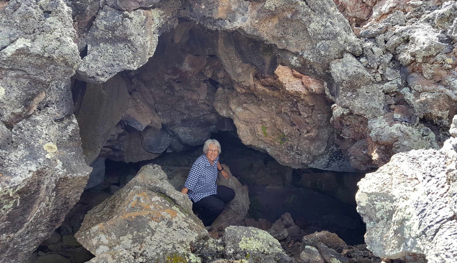
In the picture below, Denisa is modeling the latest in caving apparel. In our orientation before we got our permit, the ranger gave us a list of suggested items to have with us. We found the leather gloves and bicycle helmets were invaluable before the day was over. It's hard to see in the picture below, but Denisa was also very glad to have her head flashlight in these dark caves.
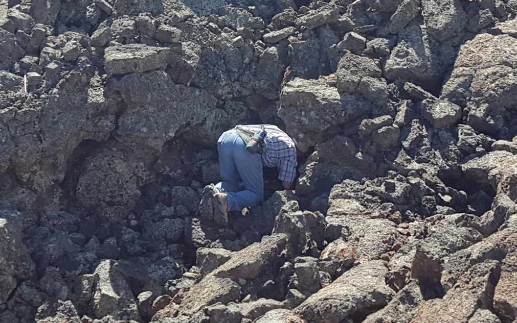
We finally made it to the entry, but not without climbing over many of those bread-box-sized boulders in the way.
The only thing harder than scrambling over large boulders in the entry, is scrambling over large boulders inside the cave in the dark. As part of our permit process, we were told to bring three sources of light per person. That's because it is very dark inside these tunnels, and there's no way to find your way out if your single flashlight burns out.
This cave has some drops and tight places. We were glad to have a ladder to help us get through this 8-foot drop gracefully.
Xenolith cave is also called the intestine cave. When we got to the tight quarters that one must squeeze through in order to get to the small intestines, we decided it was a good place to turn around. Claustrophobia is worse in the dark when you can't see if the tight space will ever get larger. You might notice the red reflector beside Mark's shoulder. Even though this cave is rated "extremely difficult," it has handy reflectors for novices. You follow the red ones to lead you going in.
Likewise, you looks for the white reflectors as you head back towards the entry. Either direction, you are climbing over those darn washing-machine-size boulders.
Xenolith Cave is found on the four-mile El Calderon Trail inside Malpais National Monument. The hike also took us by the the caldera that birthed that lava tunnel. The steam vent that spewed that lava was in the middle of this bowl-shaped valley near this mountain top.
We are getting more familiar with terms like caldera, vents and cinder cones. The last term is a cone-shaped hill formed from the lava that went straight up, hardened into pea-sized rocks while in the air, and then came straight down into this pile. There were actually two eruptions--the first one spewed more black lava, while the second had iron-colored red lava. Mark is that little dot standing on the top of that red lava cinder cone.
Standing on top of that red cinder cone, and looking over that peaceful valley, it's hard to imagine the violent explosion that reshaped this landscape 115,000 years ago.
Our permit allows us entrance into four different caves. The other three are in another section of the park. We'll drive another 15 miles (of which eight are on bumpy dirt forest service roads) to get to the Big Tubes section of Malpais National Monument. After a half-mile walk over a sharp and lumpy lava trail, we arrived at Big Skylight Cave.
Again, it was a tough climb down from the trail into the entrance of the cave.
It's hard to miss this entrance, as it is grand in size. It's also well-lit from both sides so we can actually see into the cave.
This will be Denisa's favorite cave of the day because the first section is so well lit by that giant skylight over her head.
The picture below looks like there are two bright openings into the cave. But the one on the left is just the cave wall being spot-lighted from the sunshine coming in through the sky light at the top.
With all the light, it is easier to get a picture of what the inside of the cave looks like. Once again, those big boulders make it slow-going to move deeper into the cave.
We climbed over boulders until we got to the dark back wall of the inner recesses of the Skylight Cave. Then we climbed back over the same boulders towards the skylight and the exit. There are no helpful reflectors in this cave, and it is easy to get turned around in the complete darkness.
This tunnel used to be longer, but the top has collapsed in this section. The only thing left of the cave roof here is a narrow bridge where Mark is standing.
Now that we are above ground, we hiked back to see the Skylight from the top. It's definitely cooler from below.
Not too far away, is the opening to the Giant Ice Cave. Denisa hates to complain, but that entrance was down another steep wall, then over car-sized-boulders for more than 100 yards. (Does it seem like the boulders are getting bigger as the day is progressing?) This is a work-out!
Once inside the entrance, the ceiling was a beautiful color lit up by the afternoon sunlight. This picture illustrates the size of the rocks we must scramble over to get to the back of the cave. This is like no hike we have ever done before. It's a good thing it is around 42 degrees inside the caves, as we are using lots of energy to make our way through these tunnels.
But we were intent on finding the ice in the Giant Ice Cave. We got to the back wall, and Mark climbed down where we could see water.
Sure enough, even this time of year we could find ice along the back wall. During the winter, cavers can see the seasonal ice columns that grow to be several feet high in the center of the tunnel.
By the time we scrambled all the way out and over that long entry of the Ice Cave, Denisa was pooped! The rocks had grown into motor-home-sized boulders. It doesn't happen often, but she was ready to call it quits. But Mark can't leave a project unfinished, and we still had one more cave on our permit. So Denisa let him go down into the Four Window Cave by himself.
Instead of one big skylight, this cave has four smaller ones. It was hard to take a picture with all four in it, but Mark did it.
It's even harder to take a picture of the inside of a dark cave, but he had to try. After three caves where she had to scramble over large boulders, this one's floor was almost completely smooth! Mark went deep into the Four Windows Cave because the smooth floor made it so easy. After taking this picture, he turned off his flashlights and got a good sample of what total darkness looks like.
As he came back into the sunlight in the entrance of the cave, he could see Denisa barely peeking over the edge. Boy, will she be disappointed that she missed out on the only cave that was easy to walk in!
We had a great day exploring the lava tubes, even if it was a very tiring day. We learned that the best way to take a picture inside a very dark cave is for the photographer to hold a flashlight and illuminate the area around the subject being photographed.
The results from the subject holding his own flashlight under his chin, probably aren't as good. However, the picture is probably more fitting for this Halloween season--Scary!
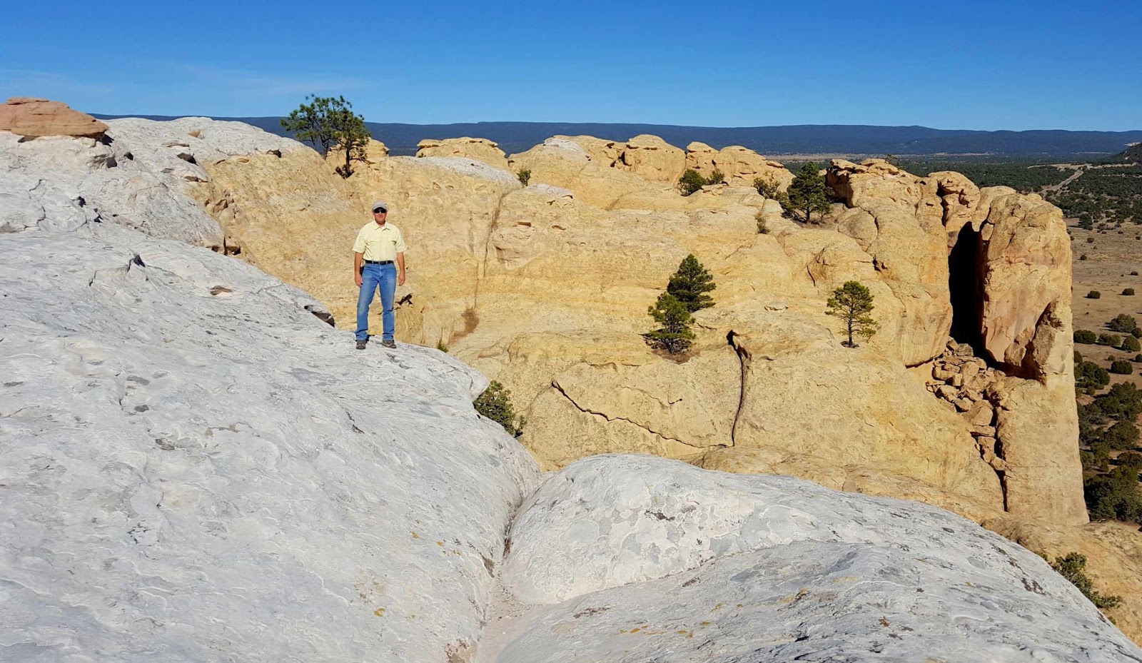
While camping at Bar S RV Park near Grants, New Mexico, we got to learn about all things volcanic. It seems this part of the state has been a hot bed of volcanic activity for millions of years. Driving down I-40, the casual tourist can't help but see all the black lava beds in the area. But we're going up close with a stop at El Malpais National Monument. After gearing up with maps and permits, our first stop is the Sandstone Cliffs. We climbed to the edge, and you can barely see Mark standing on top of the cliff. From this vantage point, we look over never-ending miles of black lava flows in the valley below.
The rains from yesterday have filled the nooks and crannies on top of the sandstone cliffs with water.
Just down the road is the star of the national monument--La Ventana Arch. It's a quarter mile walk to take a picture of one of New Mexico's largest natural arches.
But by climbing straight up over sizable boulders, we could get a closer view. La Ventana means "the window," and from this angle we can see the blue sky under the arch.
In fact, we could climb directly under to see the arch from the bottom.
Some arches are hard to capture in a picture. But La Ventana is very photogenic. It was tough climbing, but we wandered underneath this wonder for quite some time. You can see Denisa in the bottom left hand corner.
The last El Malpais stop for the day is the Lava Waterfall Trail. Now instead of looking down on the lava from afar, we are walking right on it.
We are following a mile-long loop of rock cairns and a booklet that explains the different lava formations. It obviously describes it more elegantly, but we found sometimes the lava bubbles up into giant hills.
Other times it collapses into sink holes.
At the bottom of those sink holes can be entrances into lava tunnels. The air coming out of this little tunnel is around 40 degrees. Mark knows because he was experiencing that cool air by crawling down into the entrance.
Some of the entrances are big enough to climb into, and it's a nice place to cool off on a warm day in the desert.
It's a world of cracks and crevices with puddles of hot lava frozen in time. All this lava is the result of the McCartys Volcano. The youngest of the lava flows in this region, it erupted a mere 3,000 years ago.
It was fun to explore another of this country's national monuments. We had a good day exploring another new-to-us part of New Mexico. At the visitor center we filled out the paper work for a permit that will allow us to explore even more of El Malpais. Stay tuned for more wandering His wonders as we go down under into the lava tubes.
We have never found a national park or national monument that we didn't enjoy, so we are glad to find two in our new neighborhood near Grants, New Mexico. We headed to El Morro National Monument today, and found out that these tall white cliffs are what makes it so special.
If we are going to explore events that happened at El Morro in chronological order, we're going to have to first climb all these steps to get to the top of those white rocks.
That brings us to a whole new world high above the desert plains below us.
It's up here that ancient Indian tribes built an entire city. In its heyday in 1275, it is estimated that 1,500 people lived here. After it was abandoned, the desert sand covered most of this hill-top town. In the 1950's an archaeology team uncovered a few of the 875 rooms built in this little city.
Nearby are the ruins of a larger round room with seating around the edges. We've visited enough Indian ruins to recognize a kiva--used for community gatherings and ceremonies.
It was fun wandering around the cliff-tops like the ancient Indians 800 years ago. Actually, we had a nice trail etched across the stone, complete with steps carved by the WPA in the 1930's.
We hiked all the way to the other side of the cliffs. Mark was taking a picture of the box canyon formed from this semi-circle of tall cliffs. He mentioned that we really needed a person in this picture, just to show how big these rock walls are. Denisa took that as a cue to circle back to where we had just walked. It's hard to see, but she's the dot on the opposite cliff in the top center of the picture below. If you don't see her, don't tell Denisa. She had to walk almost a mile to get there and back, and she didn't need all those extra steps on her pedometer today.
Our view from the top of the cliff shows the flat prairie that surrounds us. These tall white cliffs were easily seen for miles around, making them a landmark for many groups that would make their way across New Mexico. Many of them stopped for a while in the shadow of El Morro.
After our longer-than-needed hike on top of the cliffs, we headed back down to the prairie floor. A walkway runs right beside these white rocks that are now known as "Inscription Rocks."
For hundreds of years, travelers have been inscribing their presence onto this stone. Some of the earliest are the petroglyphs, pecked into the stone by the ancient people that lived in this area.
Fast forward to 1605, and we found one of the oldest and most famous of the inscriptions from the first governor of New Mexico. Fifteen years before the pilgrims landed at Plymouth Rock, the Spanish were exploring this area and leaving proof here on Inscription Rock.
In the 1800's, the U.S. military sent a unit to find a wagon route through this rugged landscape. Mr. Breckinridge was in charge of the 25 camels they brought with them. The camels were an experiment in military transportation, but eventually lost to the more readily-available mules. Based on the beautiful carving, Breckinridge and his camels spent much time here near El Morro in 1859.
The award for the most elegant inscription comes from another member of that military expedition. E. Penn Long of Baltimore, Maryland, must have known that travelers in 2017 would be staring at this wall more than 150 years later, appreciating his penmanship.
There are more signatures from miners and pioneers heading west beside this landmark. In fact, more than 2,000 carvings are on this great promontory in the desert. The thing that brought all those people here was the constant supply of water at the base of the cliffs.
Behind that fence is a deep pool fed by summer rains and winter snow. It's a constant source of water for the visitors that have camped here over the centuries.
We enjoyed our time wandering through the special pieces of history found here at El Morro National Monument. It's another of those lesser-known national facilities that provides a beautiful place to hike while learning more about our nation's history.


