After driving across the entire Upper Peninsula, it's time to cross the bridge that connects it to the Lower Peninsula. We've been looking at the big Mackinac Bridge for the last four days, but this morning we'll make that five-mile crossing in the motor home.
We have a Garmin Big-Rig GPS, and we had it set to "avoid tolls." Because it costs $14 for a motor home towing a car to cross the bridge, the GPS was trying to avoid crossing that expensive bridge. So it routed us clear across the Upper Peninsula, and down through Wisconsin to get to our next camping spot on the other side of Mackinac Bridge. We're thinking it might be cheaper just to pay the $14 rather than drive the 736 miles for that toll-less route.
Before the Mackinac Bridge was built in 1954, ferry boats took cars across the Straits of Mackinac to get between the Upper and Lower Michigan Peninsulas.
While Mark is busy keeping the motor home in his lane, Denisa is snapping pictures as we cross one of the longest suspension bridges in the world. Underneath us, the water is mixing between Lake Huron to our left and Lake Michigan on our right.
This is one of the shortest moving days ever--just 11 miles (rather than 736 miles) to our new camping spot in Mackinaw City. We usually drive 1-2 hours between moves. But with that toll bridge blocking our exploration of areas to the south of our last campground, we needed a couple days to explore this northern section of the southern peninsula--or as the locals call it--the tip of the mitt. Of course, Denisa had to take a picture of the Mackinaw City Lighthouse. They're doing some serious fix-up work, so this was the only angle that didn't include all the scaffolding. When it was built in 1892, its job was to shed light on Lake Huron's coast.

We found that all the museums, forts, boats and attractions in Mackinaw City carry a sizable price tag. In fact, when we asked the woman at the visitor center if there were anything without an admission charge in the city, she seemed dumb-founded. But we did find this cute historical village about ten miles away. On the weekends it has costumed docents giving tours. But today we had this free attraction all to ourselves.
Cell phones can be used to dial up a host site that explains the story behind each building. Mark is standing in front of the pest house. That is shortened from "pestilence." This building was used to house patients with contagious diseases, in an effort to keep it from spreading to the rest of the household--or the rest of the town.

Some great volunteers are working to make this village look good, and keeping its authenticity. The grounds even included a garden using heirloom seeds where the vegetables were ready for harvest.
We also stopped in at McGulpin Point Lighthouse. In just the few miles we have traveled, this house is now looking over Lake Michigan.
With our Michigan state park pass, we were also able to drive through Wilderness State Park. We can report that every camping spot was taken, and these Michigan parks are well-used in the summer. We also made a stop at the new Headlands International Dark Sky Park that is one of the best places to do star gazing in the state. So it was tricky, but we did find some free things to do even in a touristy place like Mackinaw City at the tip of the mitt.
While we are camping at St. Ignace, we decided to take a road trip to the northeast corner of the Upper Peninsula of Michigan. That's another point where Canada meets the United States, at the city of Sault Ste. Marie. Besides an international border crossing, most people visit this little city to see the big ships make their way through the Soo Locks.
Before we proceed with lots of pictures of ships, it's time for a rant. Traveling far and wide, we have to learn how to pronounce new town names all the time. We found out that this new-to-us city of Sault Ste. Marie is pronounced "Sue Saint Marie." We must point out that the famous Soo Locks found here are also pronounced "Sue." A couple months ago we were in South Dakota, where they decided to spell "Sue" as Sioux. Can you believe that words that are spelled so differently (Sault, Soo and Sioux) are all pronounced the same? Can't we all just agree on one spelling so it doesn't confuse the tourists?
A nice visitor center explains the significance of the Soo Locks. You should be prepared to learn that information too, as we include the pictures we took. From our vantage point at the viewing area, it's hard to understand what is actually happening here. So we include an aerial view that shows the four channels on the left where ships can enter a lock. On the far right, we see the rapids and rocks and steep incline of the St. Mary River that make this passage impossible without the locks.
Over 7,000 ships make passage through the locks each year during the ten months they are open. During the dead of winter, these waters will be ice, and ship transportation comes to a halt in the Great Lakes. We see one of those 7,000 ships arrive. Approaching from the left, it is coming off of Lake Superior. In order to continue on to Lake Huron, it must be lowered 21 feet.
So the nose of the ship is high above the viewing platform when it arrives.
But when the gates of the lock are closed and 22 million gallons of water are released, that ship will lower those 21 feet. The process uses only gravity to displace the water, and works the same way today as it did 163 years ago when the locks were built. Incidentally, these very durable locks were designed by a guy with a third-grade education.
We saw the opposite happen when a tour boat entered from Lake Huron . . .
and was raised in order to continue on to Lake Superior.
Because we are easily entertained, we stayed around the locks for a couple hours. That allowed us to see a tug boat and barge also make their passage through the locks.
But the main reason we stayed so long was to see the arrival of the Paul R. Tregurtha. At 1,014 feet in length, this is the longest ship on the Great Lakes. As it pulled into the lock, we could get a sense of her size with that three-story building fitting easily between her bow and stern. The Soo Locks were built in 1855, when a ship this size was unimaginable. So it takes some very careful steering to drive a 1,000-foot boat into a narrow opening with only a few inches left on each side.
Once in the lock, she was too big to fit into one camera frame. It took a panorama photo to get all 1,014 feet of her. A ship this size can carry the equivalent of 700 railcars or 2,800 semi-trucks. It's by far the most fuel efficient method of moving cargo! In fact, this 1,000-footer can carry over five times as much as the two other 700+ foot ships we saw today.
All that ship-watching can work up an appetite, so we ate at the crepe shop across the street. For some reason a marimba was on the sidewalk. We've been traveling so fast that Denisa hasn't played her piano in a long time, so she had fun tinkering with this instrument.
This is our last stop in the Upper Peninsula, as we're heading south into the Lower Peninsula tomorrow. In addition to finding out there are so many different ways to spell "Sue," we have also learned that the people of this state divide themselves into peninsulas. We are ready to wander into the Lower Peninsula to find more wonders.
We were up early this morning, as we wanted to be on one of the first ferries headed to Mackinac (remember--it's pronounced like Mackinaw) Island. The 9:00 ferry is one of the few that makes a detour so the passengers get a water-level view of the mighty Mackinac bridge.
We went right between the two tall pillars of the largest suspension bridge in the Western Hemisphere.
As we went directly under the bridge, we could see the cars and trucks crossing over our heads in the two "see-through" inner lanes. It's a little unnerving to think how much weight just two pillars are supporting.
Even with the detour, the boat ride was less than thirty minutes. As we approached the island, we could see the Grand Hotel making its grand first impression.
Denisa also got a picture of the not-nearly-as-grand Mackinac lighthouse as we sailed by.
We had been advised to take our bicycles with us, and we were glad we did. We had to buy a ticket for the bikes to ride the ferry as well. Between the two of us, and two bicycles, it was a $70 round-trip ticket.
A little Victorian town greets all the ferry boat passengers. Even though the streets seemed hectic when we first arrived, we later realized that this was the calm before the storm of tourists arrived for the day. We beat most of the day visitors to the island, and it was definitely going to get more crowded before the day was over!
We love the fact that cars are not allowed on the island. So we won't have to worry about dodging vehicles on these busy streets today. But we will still have to be watching for all the horses and carriages, and the crazy tourists!
We decided to get out of that crowded town, and started on the 8-mile road that circles the entire island.
Remember, we don't have to watch for cars. But we do have to watch for tourists that rent a horse and buggy but have never driven a rig like this before in their lives. We also read that there are 1,500 bicycles for rent on Mackinac Island, and it feels like every one got leased today. So we must also be watching for tourists who haven't ridden a bicycle in the last ten (or more) years.
There were plenty of places to pull off the road for views of Lake Huron that surrounds us.
We also made a stop at Arch Rock, high on the hill above the lake.
We found out just high that hill was when we started up the 240-step staircase.
But it was fun to get to be eye-to-eye with the Arch.
Mark was more than a little sad to find that he wasn't allowed to climb out on top of the arch. The views through the arch--down to the road and the waters of Lake Huron--were worth the climb.
After we climbed down the steps, we were back on the perimeter road. We had to try very hard to get pictures without other bike riders in them.
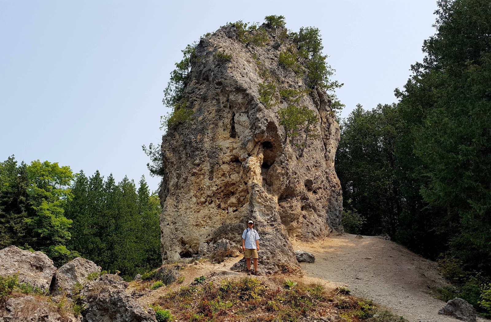
We made a stop at another unusual rock formation--Devil's Kitchen. We're not fooled by the name, as we know this island is another of God's wonders.
We've now completed the first 8-mile lap around the island, so we found ourselves back in town. A friend had told us that you will know your ferry is getting close to Mackinac Island when you get your first whiff of the strange combination of fudge and horse manure. We've already experienced the horses, and now we are in search of the fudge. This island is the fudge capital of the United States. One can't walk more than 50 steps without bumping into another fudge shop. In fact, we were surprised to find fudge shops by the same name only a block apart. The most popular seemed to be the Murdick Shops, which tout that they have been making this sugary convection here since 1887.
We headed inside to watch the fudge chefs working their magic. While one cooked up the next batch, another guy was cooling another batch on the marble tables.
A confectionary artist, he will stir and blend and shape all that cooked sugar until he forms a perfect piece of fudge. We'd hate to think how many calories are in that four-foot-long single piece.
Yet another guy is slicing up the cooled fudge into perfectly sized pieces. The three cooks are working all the time to keep up with tourists that are carrying this stuff out in heavy packages. The ferry boats will be considerably heavier on our return trip, as we read that tourists buy 10,000 pounds of fudge each day here on Mackinac Island.
Fortified with fudge samples from more than one shop, we continue our bike ride up the hill. The woman at the visitor center gave us the tip that we could get away from the crowds by going up the steep hill protected by Fort Mackinac.
She was exactly right. Suddenly we were on a deserted island with trails entirely to ourselves. It's amazing how a very steep hill will separate you from the crowds of fudge-eaters in town.
We rode all around the upper parts of the island. We found things like the the gazebo left over from the filming of the movie "Somewhere in Time" filmed here in 1979. That's now on our list of old movies to watch.
We also found the site of Fort Holmes, where a nice replica of the 1812 fort has been built on the highest point of this little island.
We walked through old cemeteries where some of the earliest residents of this little island found their final resting place. The U.S. flag is always flown at half-mast here, in honor of the unknown soldier graves in this military cemetery.
We also found Sugar Loaf Stack--a 75-foot limestone pillar that has survived the weathering of time. This made a nice place for a picnic lunch we brought, since our stomachs were growling in spite of all those fudge tastings.
Our bikes proved to be great assets, as we really got to see every bit of the island--and at our own pace. Besides renting a bike, some visitors choose to rent a horse. This doesn't look like a very fast mode of transportation, as even Denisa could pass the horses--even going up hill!
Mark took this picture just a little later, and wanted to say, "Denisa was pooped out after that horse race." Besides dodging tourists on bicycles and horses, we also are finding we have to dodge all the horse poop on the roads.
After thoroughly exploring the highest parts of the island, we have one more destination. We found a less-traveled road that got us close to some of the grandest houses on the island.
More importantly, it will bring us to the less-used side approach to the Grand Hotel. We stashed our bikes and backpacks in the bushes, and walked up onto that grand front porch just like we were rich enough to be staying there. Later we found out that the cheapest room at the cheapest during-the-week rate would cost us more than $700 for a one-day stay.
Built in 1887, it is the world's largest summer hotel. We even sat down in two of the rockers that line the longest porch in the world.
We pretended we were guests to get a view of the grand lobby. We could have stayed for afternoon high tea, but the $50 per person price tag seemed a little high for tiny sandwiches and a cup of tea.
At the grand hotel, they even roll out the red carpet for their guests.
While Denisa stayed on the porch, Mark took some pictures from the sidewalk below.
After playing like we were in an episode of "The Rich and Famous," we headed back to the real world to retrieve our bikes and backpacks. We rode to the other side of the hotel where most visitors approach. That's where guards were scaring off tourists, who had to buy a $10 ticket to get a tour of the hotel.
We took one more lap around the top of the island, and we figure we've ridden about 20 miles today.
This lap brought us a few more quintessential pictures of Mackinac Island. Because there are no motorized vehicles, horse and wagons are used to gather trash, deliver food to restaurants, and even deliver food for the horses.
Back in town, we take time to stop by the two churches. The first is the humble first mission church that was built here in 1829.
The second is the grander Sainte Anne Church, a staple steeple of the island.
A long line of horses and carriages are lined up on the road, waiting for those visitors that didn't want to pedal their way around the island.
We had a hard time finding a parking space along Main Street among the multitude of bicycles. We thought it was crowded early this morning when we arrived, but it is crazy busy by late afternoon! We stopped at one more fudge shop to get our last fudge-fix before we board the ferry back towards the reality of life in a world filled with cars.
As we leave Mackinac Island, we also leave behind that interesting combination smell of fudge and horse manure. It's been an interesting day on one of America's most interesting islands.