After a week of full-hookups at Fidalgo Bay RV Resort, we are heading down the road again. This day's journey will take us south, past Seattle's traffic, to the mountainous area around Snoqualmie, Washington. We are casino-camping for a couple nights at Snoqualmie Casino. It's one of the least level RV parking lots we have ever seen. But we are surrounded by mountains, and level is not easy to find in this landscape. When we first arrived, we explored the tiny town of Snoqualmie.
With all the tree-covered mountains surrounding it, Snoqualmie has a long history of logging. We were greeted to town by this large wheel. It's a good thing there was a plaque with a description, because we were clueless. It is an 11-foot-tall vandmill wheel that once supported the 65-foot band saw blade at the local saw mill. This saw was big enough to cut even the biggest Douglas fir logs that came out of these woods. It was in service from 1917 through 1964, and cut enough lumber to build 275,000 homes.
The railroads came to town, making a way to move that lumber to the rest of the world. Mark is sitting in front of the picturesque Northern Pacific Depot that was built in 1890.
The logging trains don't seem to travel through this area now. But the tracks are still used for tourist train rides that were very popular on this beautiful Sunday afternoon.
Instead of a train ride, we preferred a little bike riding on the rock paths that wind through the woods around town.
This is a rail-to-trails path, that goes over the Snoqualmie River. This is the same river that we visited a couple weeks ago with our son and his girl friend. About a mile from here, this quiet little river cascades more than 200 feet straight down to make the much-photographed Snoqualmie Falls.
This bike path also took us close to the grand mountain of this area--Big Si. Its imposing rock face makes a great backdrop for the town as it rises more than 3,000 feet above the valley below.
We looked longingly up at that mountain face during our bike ride. That's when Mark did a little research to find there was a hike to the top of Mount Si. It's a very popular trail in this area, and it looks like we'll be taking that hike tomorrow! Again, we've found a place that we didn't even know about before today, and we're finding plenty of fun things to keep us busy.
We love going to local festivals, and we are finally approaching the summer season that is filled with opportunities to party with the locals. We were especially looking forward to attending the "Berry Dairy Days" in Burlington, Washington. We both like ice cream and berries, so this sounded like a very tasty festival to us. We got there just in time to watch the parade, including the Grand Marshall waving from the passenger seat of an old fire truck.
The neighboring town of Sedro-Woolley was advertising for its upcoming rodeo. A large group of horses and riders included last year's rodeo queen. We thought it was more interesting that the queens from 1953 and 1971 were also in the parade with all their royal finery.
We were rather underwhelmed with the absence of dairy and berries at this festival. There was an agricultural presence in the parade with a display of antique tractors. But the only berries we saw were the high-priced strawberry shortcakes for sale at the visitor center. It would be a stretch to count the whip cream on top as the only dairy we saw.
After the parade, we went through all the booths and tents in search of dairy and berries. We are sad to report that there was none. We did win prizes for our ability to throw bean bags into a hole. Actually, the main reason we include the picture below is to showcase one of Denisa's favorite part of our stop. After bemoaning the terrible haircut she got in Oregon, Mark insisted she get a new cut at a salon our next door neighbor has used for years.
We were sad that we missed the largest festival in this area by a couple months. April's Tulip Festival in Washington's Skagit Valley is attended by hundreds of thousands of people from all over the country and the world. With extra moisture this year, it sounds like the 2017 display was spectacular. We knew we were too late, but we visited the RoozenGaarde tulip farm to imagine what we missed.
The four-acre display garden here is planted each fall with a quarter million spring-flowering bulbs. Where the bare soil is today, was a bright maze of tulip color in April. Denisa is holding up a picture of the tulip display that was planted under that tree just a couple months ago.
We got lots of information about tulip farming here in Skagit Valley. They grow more tulips here in this valley than any other place in North America. They also grow twice as many daffodils as their famous tulips. There are many tulip farms, and we visited just one today. During the festival, the RoozenGuarde farm will have 350 acres of tulips, and 450 acres of daffodils blooming. But since they can't replant tulips on those same acres for another five years, they have to farm five times as many acres. They will plant potatoes, clover, or barley to rebuild the soil for those five years to ready it again for the tulips.
The picture above is what is left in June of one of those lovely April tulip fields. The blooms are gone, and the leaves have naturally been allowed to yellow and die. The summer harvest is now underway. Tractors pull implements that dig up the bulbs to be cleaned and shipped out to customers in time for fall planting.
This company also has acres of greenhouses, raising more bulbs all year long to be shipped throughout the country as fresh flowers. If you see a tulip in a bouquet in the winter, it probably came from the greenhouses in Skagit Valley. As we meandered through the country-side to find spent tulip fields, we also noticed a full parking lot at a local plant nursery with banners announcing their "Rose Days." Mark whipped the car in for this impromptu stop. We found ourselves in the middle of a rose-judging competition where participants were vying for the people's choice award.
There were speakers lined up throughout the day to teach the latest techniques for growing roses. But we were most excited about the ice cream social. We got in line for the cones, surprised to find that it was rose-flavored ice cream. It wasn't our favorite flavor, but it was certainly a new experience.
The rose show was hosted by a local nursery, with beautiful displays of flowers inside and out of their greenhouses.
We know the topic of the day was roses, but we were mesmerized by the hanging fuchsia plants. The blooms start as balls, like the ones on the right side of the picture. Then they pop open into brilliant color combinations that are beautiful to behold.
Some of the color contrasts were eye-popping. The flower below reminded us of the red hatters organization for (ahem) mature women. They wear their purple dresses with red hats--just because they can.
We found something new on the back roads of the Skagit Valley. We had to pull over when we saw this "Talking Field" billboard. When we focused our smart phone at the QR code on the sign, it told us about the dairy farm that uses the field in front of us. They are using new technology that allows the cows to determine when they need to be milked, and then has an automatic milker that is available to the cows 24 hours per day. That's something we wouldn't have known from just driving down the road without access to a talking field.
We always enjoy rambling through agricultural areas in a new part of the country. We did see many acres of berries in this valley, as well as a few dairies. So even though we were disappointed with the Berry Dairy Days festival, we felt like we saw and learned much more today.
We used to think of islands only with palm trees and cabanas. But we are getting used to living in the state of Washington's version of island life. Our campground is on Fidalgo Island, and we took a ferry to visit San Juan and Lopez Islands. Just eight miles from where our motor home is parked we can visit another island--Whidbey. We can visit Whidbey Island without getting on a boat because there's a beautiful bridge that connects the two islands--Deception Pass Bridge. If you look carefully, you can see Mark standing near this end of the bridge.

This two-part bridge was built in 1935, to span the treacherous water of Deception Pass. We didn't realize that it was such a famous icon until we saw that the two parking lots on either side of the bridge were full with visitors taking pictures. We also found that 15,000 cars pass over this bridge every day. So we had to join the other tourists to get our picture on the bridge. With the high winds over the water and the roar of the traffic only inches away, it did feel like a treacherous journey across the Deception Pass.
The tide was coming in, and we could see the turbulent waters of the pass going under the bridge. We had already been warned by a local kayaker to stay out of that flood going through Deception Pass when the tide comes in. The current is impossible to row a kayak against.
Deception Pass State Park has hiking and public beaches on both sides of the bridge. We did some hiking to the heads that overlook the Salish Sea, to get pictures of this beautiful coastline of our island.
We found another new-to-us wildflower growing at the edge of one of those high hills overlooking the water. Mark was hanging on to Denisa's shirt-tails because he thought she was getting a little close to the edge to get that picture of the flowers with the rocks and water far below.
On another hike, we could also get pictures of the Deception Pass Bridge. There's an island in the water that supports the middle of the two-part bridge. We found out that this water passage between Fidalgo and Whidbey Islands got it's name in 1792 when Captain Vancouver "felt he was deceived as to the nature of the inner waterway." He wrote on his chart "Deception Pass" and the name stuck. Yeah, we thought the story would be better than that too.
We took a longer hike up to the Lighthouse Trail in the state park. We must say we felt like we were deceived, because there was no lighthouse on the lighthouse trail. Lots of pretty views high above the water where a lighthouse should be--but no light.
We were also deceived by the trail signboard that indicated this was a loop trail. After enjoying the summit, we took off on a spur trail that ended abruptly in the forest. It took some hardy bush-whacking up and down steep inclines to get back to some semblance of a trail. Denisa might be smiling as she emerges from the bushes, but she wasn't too excited about this loop trail a few minutes earlier.
On another day we explored the western shores of Whidbey Island, at Fort Ebey State Park. We're still looking for that pod of orca whales that live in this area, but we were skunked again today.
We later stopped in at Fort Casey State Park, also situated on the west side of the island. This fort was first constructed in 1897, and was last operational during World War II. The U.S. had guns pointed to the sea in case the Japanese ships would try an attack on the mainland through this strait. It's a good things all the guns were decommissioned long ago, since Mark seems to be standing right in front of the ten inch gun barrel.
Denisa is happy to report that we weren't deceived this time--there really is a lighthouse at Fort Casey State Park. The Admiralty Head Lighthouse is one of the prettiest we have seen in a while, with a lovely new paint job and flower beds in front of the lightkeeper's house.
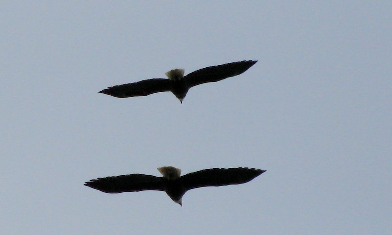
As we stood by the water in front of the lighthouse, we enjoyed another bald eagle fly-by show. This pair of mature eagles was flying close together in formation--buzzing right over our heads. It looks like they have been taking lessons from the Navy airmen that work and train at the navy base here on Whidbey Island.
We feel like we have explored yet another island on this stop in Washington. We haven't seen any palm trees yet, but we can confirm that there are plenty of beaches and miles of shoreline in this section of the state.
We are right in the middle of lots of water, so we certainly wanted to put our kayak to good use during our stay. We checked out several of the mountain lakes around us, but finally decided we should go for water on a bigger scale. Below is a picture of our location and all the water around us. There's some glare on the map, but it will give you a bird's eye view of our location. We are in the town of Anacortes, on Fidalgo Island, which is found on the bottom right hand corner of the map below. The map shows most of the bigger islands around us in the Rosario Strait in the Salish Sea in the state of Washington. For a layman's description, we're in the northwest fuzzy part of Washington where it's hard to determine where the U.S. ends and Canada begins because of all the water.

All these places sounded foreign to us not long ago. As a matter of fact, we're not far from foreign territory since the dotted lines in the left hand bottom corner is the Canadian border. But that's the beauty of living in a motor home and being able to explore new territories for weeks at a time. We get to learn about new places that we didn't even know existed. To further explore this new territory, we inflated our trusty kayak and set out on the waters of the Salish Sea that surround us here on Fidalgo Island.
We put the kayak in at the Cap Sante Boat Marina that is just a couple miles from where we are camped. The water was calm as we made our way across the channel entrance where the big boats cross from the marina to enter the sea.
We like to see the blue outlines of the mountains on the other side of the water. We can even see a tall, snow-covered peak that is partially hidden in the clouds. It's a great day for a boat ride!
We feel a little dwarfed by this huge ship that is being loaded on the industrial port across the water. Actually, we seem tiny next to the two smaller tug boats that were pushing it sideways into place at the harbor.
We got some great advice from a professional kayaker that was escorting a group of people finishing up a four-day kayak trip around the San Juan Islands. He took the time to sit down with us and show us a map of the waterway. His best advice was to hug the rocky shore of Fidalgo Island and watch out for the big boats. So that's exactly what we did. Since it was low tide, we also saw anemones and sea stars hanging on to those rocks just below the water.
We made the circle to get the feel of the sea. Denisa was glad to have this brave rudder man when the passing boats made big waves for little kayaks.
After our loop into the open water, we decided to check out the boats moored in the harbor. There are boats of all sizes lined up all the way to the channel.
We pulled our inflatable kayak in between two yachts. We felt a tiny bit small in both size and price tag.
These boats are kept shiny and clean even in this salt water environment. Our images were reflected in the shiny paint of the dark yacht. This is probably as close as we will ever get to yachting.
As pretty as these big boats are, we prefer our little kayak for our water travel. Then we like our "land yacht" for moving around this beautiful country's highways, as we learn about new places that we didn't even know existed before we retired.
We had planned to explore two different islands in the San Juans, and we had figured it would take two days and two ferry tickets to get that done. But while we were on the west-bound ferry going to our first island, we found out that passengers can stop in at other islands for free on their east-bound ferries towards home. We just got a bonus island visit for free! The fact that we got an hour earlier start to our day now became more important since we're going to get to squeeze a stop to Lopez Island into our day's itinerary. So after exploring San Juan Island (as described in the last blog), we headed back to the ferry. Our plan worked because there was room for our car on an earlier ferry out of San Juan than we had reserved. So we boarded the 4:30 p.m. ferry out of Friday Harbor . . .
and about thirty minutes later found ourselves hiking through the forests on Lopez Island.
We had been given the advice to go to Shark Reef Sanctuary, and we are looking over the bright blue waters for any sea life this afternoon.
It's a beautiful place to be, but none of the orcas or sea lions are playing under the sea cliffs near us today.
But as we looked up, we saw that this is a bald eagle playground. We watched as two mature eagles flew through the air just over our heads. There are over 125 bald eagle breeding pairs in these islands--and one source proclaimed this the largest concentration in the lower 48 states.
Our original plan was to ride our bikes around Lopez Island, and spend one entire day here. Now that we have changed this to a late-afternoon exploration, we are glad to have the car to zip around. Lopez Island is only a few miles wide and 15 miles long. We saw lots of people biking on its narrow and winding roads. But we don't like biking with car traffic (just like we don't like driving a car with bike traffic). So now we are really glad that we are able to do two islands in one day. Far fewer people visit and live on Lopez island, so we saw more wildlife out in the open.
The other advice we got was to visit Spencer Spit State Park. We're still getting good use out of the Washington state park pass we bought several weeks ago. We parked and walked to the water to see this idyllic view right in front of the beach-front camping spots. These few tent sites are well sought after, and were all filled for this evening.
We haven't had any flowers for this blog, so Denisa just had to take a picture of the wild pink roses that seem to be everywhere on the islands. On Lopez, we see miles of wild roses as they are wound around most of the fences along the roads. They are in full bloom right now.
We were headed back to the harbor when we saw a group of birds gathered around something on the side of the road. We were surprised to see two vultures and two bald eagles fly up from the single carcass where the four birds were eating together. This young bald eagle flew up into the tree right beside us.
We were first in line at the ferry terminal. We need to catch the final boat of the evening, and we certainly didn't want to miss it. We had an extra long wait, since it was running 25 minutes behind schedule for some reason. Where this morning's ferry was packed full, the last ferry had less than a dozen cars on board.
The good news about stretching this day to include two islands were two-fold. We made best use of our expensive ferry boat ticket, and made great use of a beautiful weather day. We also got to finish our day on an island cruise, watching the sunset over the San Juan Islands. We have been blessed to wander into another of God's wonders today!