We are staying in a campground a short drive east of Washington's second largest city--Spokane. The first order of business is learning how to properly pronounce the name of the city, since we found out we have been saying it wrong all our lives. So for the last week, we have been practicing saying it like the locals--"Spo-can."
The city of Spokane is proud of the walking/biking trail that winds its way through the city. We parked the car at Mission Park, and used the Centennial Trail to explore the middle of the city.
Our first stop was in the Riverfront Park, where Denisa changed her bicycle wheels for some wagon wheels. That's a big radio flyer wagon in the park! The handle of the wagon is a slippery shiny slide that gets really hot in the sunshine--Denisa knows from first-hand experience.
The Centennial Trail follows the Spokane River, that snakes its way through the city. There are a series of biking bridges that cross the river, and we crossed almost all of them.
Some of those bridges are over Spokane Falls. There was lots of white water on the river, so we were never sure which fall was "the falls."
The Centennial Trail heads out of town, where the views of the Spokane River get less urban and more natural.
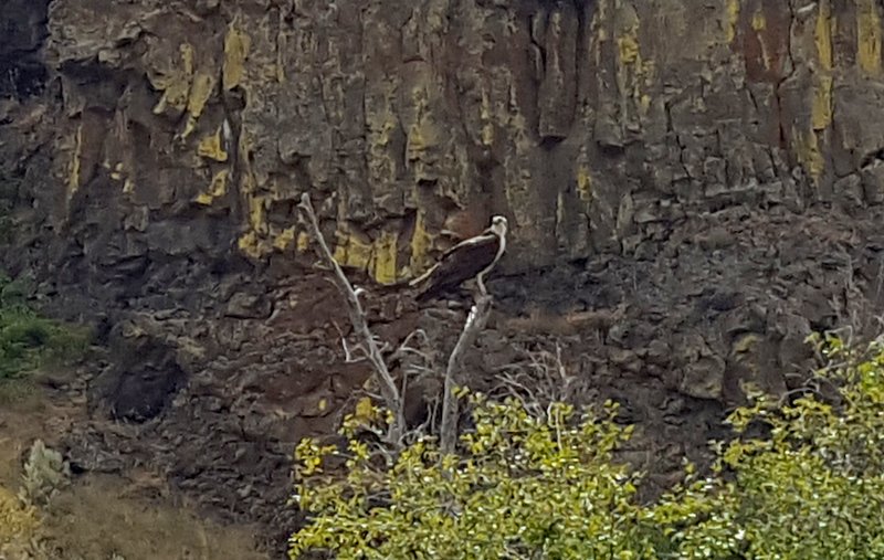
We even saw a little wildlife as we got further away from the city. That's an osprey nest high above the trail on the pole. The resident osprey is perched at the top, with the babies poking their heads up occasionally.
The trail got hillier as we got further out of the city. That was our cue to turn around to head back to the car. On the return trip, we wound our way through Gonzaga University's manicured campus.
We love touring college campuses, and this one was very peaceful during the summer semester. The Catholic church is the show piece of campus, and we rode our bikes right up to the front doors.
The church chimes struck noon as we took pictures. At that time of day, the summer sun is perfectly aligned behind one of the crosses on the steeple.
Gonzaga's most famous alumna is Bing Crosby. The famous entertainer's statue is right next to the Crosby Building on campus (and the handsome biker in the blue shirt visiting campus).
We enjoyed touring downtown Spokane on our bikes, without struggling to find parking spots.
There are some lovely parks and bridges along the way, and we always had the Spokane River beside us.
The high temperature for the day was 85 degrees, and with the shade it was very comfortable on our bikes. We are finding that this area's average summer temperature is 85, but we have higher than average temperatures forecast for the next few days.
We rode our bikes back to Mission Park, and did the rest of our Spokane tour in the car. Denisa has been sneaking in pictures of her favorite roses from our next destination--Manito Park. They have a radiant rose garden, now enjoying peak blooms.
While Mark patiently rested in the shade, Denisa wandered through more of God's wonders. She couldn't help but take a few pictures of her favorite roses.
Denisa loves a good (and free) botanical garden at peak bloom!
Besides the beautiful blooms outside, there is also a conservatory brimming with unusual plants indoors.
They had everything from the elegant orchids . . .
to prickly cacti with their bright summer blooms.
Just outside the conservatory is the formal Duncan Gardens. It felt like this beautifully symmetrical garden should have been at the foot of a castle in Europe.
It was hot enough outside that we were glad to retreat indoors to our next stop at the Cathedral of St. John the Evangelist.
Built in 1925, it has beautiful stained glass windows, and is one of the top places to visit according to Tripadvisor's list of tourist destinations in Spokane. We have never gone wrong following Tripadvisor advice.
We finished our tour of Spokane with some shopping, as this is one of the last sizable cities we will be visiting for a while. We are still catching up from emptying out our pantry when we left the motor home for three weeks earlier this month. We also stopped for Chinese food on our way home. Those that know and love Mark will enjoy his fortune cookie's words of wisdom.
We have enjoyed a day of touring Washington's second largest city, and we are becoming quite proficient at pronouncing Spokane correctly. We highly recommend the city's bike trails, and found it our favorite way to explore. They were truly happy trails. We end with yet another flower picture, this time from the dahlia garden at Manito Park. How all those petals unfold so perfectly in a bloom that is as big as a saucer is another wonder to us. Happy Trails!
We are discovering that it can be difficult to find campgrounds in a beautiful part of the country during the busy summer season. It seems that everyone is squeezing in a vacation while the kids are out of school. Several weeks ago we made reservations across Washington and into Montana as we are making our way towards Glacier National Park. That's totally different than the usual "we-don't-know-our-next-stop-until-we-get-there" style of wandering. As we usually move about 100 miles at a time, the only open spot this time was at the Casino just west of Spokane. Without electricity, we found that the inside of the motor home can get hot even here in the northwest. We won't be trying any more boondocking until it cools off a little more.
Our next stop is a six-night reservation at Liberty Lake Community Park. We drove uphill on a narrow winding road to a campground nestled in the pine trees surrounded by mountains around the lake.
On this Sunday afternoon, the little beach around Liberty Lake was stacked with people trying to get cool when the temperatures were a blistering 88 degrees. The people up here are not used to warm weather.
We did some hiking in the mountains that surround the lake. It was great to just roll out of bed and onto the trail. This morning we were out early enough to find a deer close to the trail head.
Less than another mile down the trail, we found another doe enjoying the openness of the trail.
We heard that many people hike the two miles to the Great Cedars section of the trail, and then return back to the campground. The cedars are big, but this doesn't seem like a final destination.
We aren't smart enough to turn around so early. We continued on to the top of the foothills, where we saw a tiny waterfall. This part of Washington hasn't seen any rain for almost a month. For this rainy state, that's a long time. We're constantly reminded on the news that fire danger is high. In fact, there are several wild fires not far away.
We continued to the top, and made the 9-mile loop before we returned to the motor home. It's nice to take a hike without even moving the car.
While we really like our park, we do have one complaint. They have a large sign that describes the flora and fauna of the park. It lists the many different types of trees, and we just happened to notice that one of them was misspelled. Mark has a long-lost botanist in his family, who named everything from cactus to trees during the 1800s. We took this picture with one Engelman sitting beside the misspelled "Englemann." The extra "n" at the end is accurate in the 1800s, before they removed it to be a little less German. But switching around the order of the "el" in the middle of the name is just wrong.
Our spot at Liberty Lake puts us right in the middle of fun things to do. We are just two miles from the Idaho border, and a short drive from Spokane--the second largest city in Washington. We think we are going to like it here!
We have enjoyed some unexpected fun among the coulees here in central Washington. We are in a shaded camping spot at Coulee City Community Park on the shores of the crystal clear Banks Lake. This is a first-come-first-served campground, so we can stay here as long as we want and are willing to pay their $30 per night fee. That is the good part of Coulee City.
But the bad part is their 30-amp electrical hook-up is one of the weakest we have found, so we are having to be careful about our power usage. That is tricky when we need to wash ten days of laundry plus run the air-conditioner during 90-degree weather.
Another good thing is our neighbors here at the park. Mark helped the young family camped beside us on their maiden voyage in their used trailer. Paul didn't know how to hook-up the sewer hose (or where it was), and Mark also gave him an o-ring to keep their water hose from leaking. As we got to know Paul and his family better, we came to find an interesting thing about many of the people that vacation here at Coulee City. Our camping neighbors on both sides immigrated to the U.S. from Ukraine as adults. The two families didn't know each other, but both live in the Seattle area. They both speak their native language at home and attend Pentecostal churches where the sermon is not in English. They invited us to come join them for church the next time we were in Seattle. One family immigrated ten years ago, the other 25 years ago. All this prompted discussions about moving to a new country, and lessons about the geography and culture of Ukraine. We accidentally learn such interesting things in our travels!
We plan to move on, but we had one more hike we wanted to take. So we drove the 15 miles to the Northrop Canyon trail head. Nestled in the canyon with tall coulee walls on both sides, we had read good things about this hike.
We were enjoying a day with high temperatures in the 80's, and we started early (for us) in the morning to beat the heat.
But less than a quarter-mile down the trail we came upon a shaded section with a flock of mosquitoes intent on taking blood samples. We fogged on the insect repellent and pressed on.
We noticed that the trail was not maintained, with increasingly tall weeds. One of us was ready to turn around when she was wading through shoulder-tall weeds along a narrowing path.
Denisa didn't like this narrow trail even when the weeds had little white flowers on the top.
We could rarely see the ground because the weeds were so thick. It was one of those rare ground sightings that Mark saw a snake cross the trail right in front of him. Denisa finally insisted that it was time to turn around!
That's when we figured out we had missed a turn of the trail that was hidden because of all the tall weeds. We continued a little further along the rocky path beside the canyon wall. The picture below would be really interesting to a geologist. It shows the different lava layers from different volcanic eruptions. We don't want to get too scientific here, but the budding geologist in us has to point out the squiggly curly formations above the straight columns.
Stumbling through the layers of scree, Mark spotted a sure-footed marmot quite at home among the rocks.
He found two more on top of the rock pile, looking at something more interesting than Mark and his camera.
In the distance we finally caught a glimpse of the abandoned Northrop family home in the valley. But the buggy, weedy, sweaty hike just wasn't any fun.
As we headed back towards the car, we decided the only good part of this trail were the marmots. We spotted one more along the trail, looking very wise and thoughtful.
Back at the trail head, we decided to give the other trail in the area a chance. The stage coach trail went steadily up-hill, with steadily better views above the valley.
As we climbed to higher elevations, we could now look down on Banks Lake. That island in the lake in the background is Steamboat Rock, where we hiked a couple days ago.
Denisa had announced that if she saw one more weedy section or one more snake, she was giving up on this trail and heading back to the car. Sure enough, we saw another snake slithering across the trail.
This guy wasn't a scary poisonous snake, but he certainly wasn't as warm and fuzzy as a cute little marmot.
We also heard a distinct rattle but didn't see that snake. On the other trail, we wonder just how many snakes we had passed in the tall weeds without knowing it.
Of all the beautiful and fun hikes we get to enjoy, some times we find a bummer hike like in Northrop Canyon. Mrs. Northrop was murdered in the wash room of the family house, so it sounds like she didn't have a great time here either.
We did find another good part of Coulee City--the paved memorial trail that starts right at our campground and winds along the shore of Banks Lake. The second time we took the trail, we got in a goose traffic jam.
The trail led to openings to watch the sunset over the lake.
After four days at Coulee City Community Park, we have discovered the good and bad of this area. But we feel blessed to see and experience new things in new places, and we are ready to move down the road to more adventures.
At our camping spot in the Coulee City Community Park, we are just a couple miles from a very interesting natural site. We were a little surprised that we hadn't heard more about the world's largest waterfall so close to us. The precipice (that's fancy talk for the steep cliff the water falls over) is 3.5 miles wide, and there is a 400 foot drop. In fact, when compared to Niagara Falls it is five times the width. So why aren't people flocking to see it? Well, there's one thing missing from the equation for making this a prime tourist site--water going over that precipice.

Yes, we are visiting Dry Falls State Park today, and we can confirm that the falls are dry. In the picture above, we see the flat rim where the water of the ancient Columbia River once roared off the edge and down 400 feet. It must have been spectacular! In the visitor center, there is a film with a computer-generated animation of how it must have looked. But the Columbia River was re-routed thousands of years ago by a huge ice-age flood that formed all the coulees we are enjoying. So now we can look down-stream to see where the roaring river used to flow.
The only water here now are the clear spring-fed lakes that lay up and down the road on this stretch of the highway. In the picture below you can also see Denisa standing up on the observation point, separated from the rest of the wall of the coulee.
Just a mile down the road is another Washington State Park--Sun Parks. We started out on a trail beside Deep Lake on a beautiful morning.
We haven't had a flower picture in a while, and this bee was certainly enjoying the tall purple flowers along the trail.
Mark scrambled up on one of the large rock haystacks along the trail to get a better view down the narrow lake. You can see Denisa far below on the trail in the bottom center of the picture. We were both sweating with temperatures in the upper 80's on a trail with no shade.
That's when we decided that it would be a lot cooler (in more than one way) to kayak down Deep Lake, rather than hike beside it. We were glad that we always have our inflatable kayak in the car with us, so it only took about ten minutes to get on the water beside those tall black coulee walls.
People without boats were staying close to the parking lot end of the lake. You can see the big splash as another person jumps into the water from the natural rock ledge. The water gets very deep very quickly here at Deep Lake--perfect for jumping in from the edge.
That water is cool and clear, and a beautiful blue-green color. The ranger said that Deep Lake is about 125 feet deep. For a narrow little channel lake, that seems crazy deep to us.
From her seat at the front of the boat, Denisa kept taking pictures of the massive walls of rock that we were floating beside. But a picture like the one below just doesn't have anything to show the scale of its size.
So Mark dropped Denisa off on one side of this narrow lake, so she could take a picture of him in front of the coulee wall. Here's a picture of him rowing the kayak by himself so you'll know what to look for in the picture as he gets further away.
You can still see our two-man kayak in the water in front of that tall rock face as he gets further away.
But it's really hard to see that 12-foot boat in the picture below. We promise it's still there, but Mark is feeling and looking very small.
There were several other kayakers on Deep Lake this morning, and it was fun to try to picture them as they rowed beside these tall cliffs.
The winds were kicking up, and pushing us easily north along Deep Lake. There are three bright kayaks in the picture below, but they are so dwarfed by the beauty around them they are hard to see. Our fellow kayakers were warning us that it got windier around the curve, and it was really hard to row back against the wind. But of course, we weren't about to quit before we got to the end of the lake.
So we continued to let the wind drift us easily to the end. There we snapped a picture of a couple in a canoe, getting ready to turn around and face the wind for the two miles back to our cars.
We got a good arm workout, as it took continuous rowing just to keep the kayak from going backwards. We were secretly racing the other canoe back to the finish line, even though we were on the opposite edge of the lake so they didn't know it.
But we got distracted when we saw that swallows had built nests on the walls of the coulees. Right above our heads, we could see these little art masterpieces that were swallow nests.
Wherever there was a little rock overhang, there would be a swallow nest under it. They blended in well with the rock wall, and we tried to convince ourselves that we were glad the wind was slowing us down so we noticed them. But our arms were getting tired from the struggle with the wind, and stopping to take pictures meant we were losing the race.
We found a little cove with some protection from the wind. The birds must also like this cove, as we spotted a heron, and then an osprey in a tree.
It's hard to see the osprey in the picture above, so we'll zoom in on him. With the phone on the camera, the images aren't crisp, but he was posing on top of the dead branches for us.
We are totally losing our imaginary race against the canoe as we stopped to watch the osprey. He let us float into the base of his tree before he finally decided to take to the air and fly to another perch.
It was a great float on Deep Lake, and the wind helped us get everything dry so we could load our Sea Eagle kayak back into the car. We are driving further south now, watching the beautiful coulee walls and the clear blue lakes that share the valley floor with the highway.
Our destination is 16 miles south to a unique place--Soap Lake. We had to wade into the water to experience for ourselves why it got its name. Sure enough, the water was slick just like it was soapy bathwater. The ranger explained that this alkaline lake evaporates so much liquid that it leaves a high concentration of minerals in the water that is left.
We had heard that people come from miles away to experience the spa-like treatment of a day at Soap Lake. We saw people soaking in the shallow mineral water. We also saw others smearing the black mud from the lake bed all over their bodies. When Denisa approached, this group of Asian ladies met her to share their treasured lake mud. Since they didn't speak English, our only "conversation" was an outstretched muddy arm.
This is what the miracle mud looks like. This time it's probably a good thing we don't have smell-a-blog, because it smells even worse than it looks.
Denisa's not one to pass up an expensive spa treatment for free, so she began lathering it on her arm. The mud goes on easily and dries quickly.
She tried an experiment, covering only her left arm and leg. This way we could compare the miraculous effects with the un-mudded right side.
The black mud dries quickly to a gray that has the texture and color of an African elephant. It smells a lot like that elephant as well. So far this fancy spa treatment isn't as glamorous as she had hoped.
After baking in the mud for a while, she used the soapy water of Soap Lake to wash it off. The experiment's results were a little inconclusive, so it didn't warrant another trip to Soap Lake to mud up the other side. She couldn't wait to get home to bathe properly, as the smell was quite persistent even after rinsing in the lake.
We were a little disappointed with the town of Soap Lake, even though we enjoyed getting to buy more local cherries and apricots at the grocery store there. The neatest part of town was this beautiful sculpture on the lake shore. That outstretched eagle wing is actually the dial on this sun dial that shows it is 3:40 in the afternoon.
So we end another day of exploring the lakes and coulees around our camping spot in Coulee City. We hadn't planned to kayak in Deep Lake or get muddy at Soap Lake. We love the unexpected experiences that we wander into as we wander His wonders.