Sunday, September 26, 2021

Having a more pleasant "Corona" memory

We had read that the national parks are seeing a record number of visitors this summer. It seems that the American people are following corona virus protocol to social distance and be outside by going to the national parks. The ranger at Arches National Park knew all about the crowds. So he suggested a hike outside of the park that would be less crowded. Instead of making a right turn into the park, we took a left turn and drove the road along the Colorado River this morning.

We had meant to get up early this morning, but it was hard to convince ourselves to get out of bed at 5:30 a.m. So we didn't get to the trailhead until 7:45.

This trail has several sections that might make some hikers uncomfortable. For example, there is the steep section that requires using a chain.

Then there is the ladder section that aids in getting over another tall incline.

Finally, there is a chain section that keeps hikers from sliding off another steep incline.

It was a 1.5-mile hike this morning to get a glimpse of our first destination. "Corona" has been tied to a nasty virus for the last year, so it's nice to find a more pleasant use for the word. Welcome to Utah's Corona Arch. The sun is climbing in the sky behind the arch, and we has just arrived under the arch.

We got a much better picture of the Corona when we walked through the arch and had the sun shining on it.

We love those red arch and blue sky pictures! It's so nice to be out of the smoke today!

Even though we aren't in the national park today, these sturdy arches are found in several places in this part of Utah.

This hike should be called "The Triple Arch Challenge" because we have the option of hiking to three arches today. The second one was an easy detour to Bow Tie Arch.

Looking straight up, we got a nice slice of blue sky through the Bow Tie.

It's a 1.2-mile detour to the third arch, and it is certainly warmer by this time. But we did the longer hike to Pinto Arch.

It's quite high off the ground, but we didn't take a panorama picture because a group of hikers were congregated under the arch. Note to self: don't ruin everyone else's photo opportunities because you decide to take a thirty-minute break in the most picturesque point of a landscape. That's just a little pet peeve of ours.

By now it is 9:30. It's quite warm and we were wishing we had gotten out of bed sooner. But we did make the triple-arch challenge, and we can confirm that there are wonderful arches to be found outside of the national park (and across the train track). 

In a time when a crazy virus has made corona into a bad word, today we made more pleasant memories of the Corona--and its two other sister arches.


Friday, September 24, 2021

What is the best place for sunset at Arches National Park?

We have been traveling straight east for days, but we took a detour off Highway 50 for a stop at a special national park. Six years ago we spent a week here at Moab, Utah. In our rushed trip this year we'll only get to spend three days in this area. So we got started right away with an evening drive into Arches National Park. We were looking for the best place for sunset. We waited to go into the park until around 6:00 p.m., hoping that the sizzling temperatures would be cooling off a little by then. The sun was low in the sky, lighting up the big red rock formations that greet visitors to the national park.

This is one of the biggest red rocks, Courthouse Towers, so we parked to take a closer look. With Mark standing close to the parking lot, that doesn't look so big.
 
But when he ran up to get close to it, suddenly it looked very big. In the zoomed-in picture below, you can see that Mark is about the same height as that white stripe of rock at the base.

In the big picture, you see that white stripe is very small, and very low to the ground at the base of Courthouse Rock. Can you see Mark standing in front of that stripe at the bottom in the picture below?

Likewise, the funny knobs of rock in the distance seem small. 

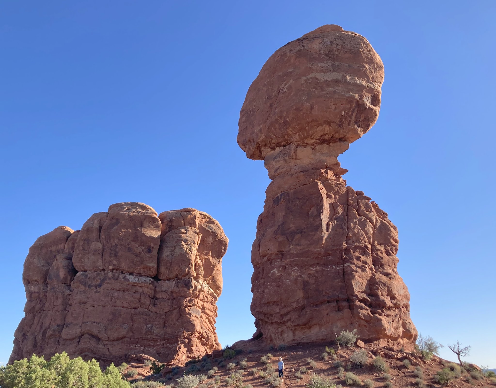
But when Denisa stood under Balanced Rock, we found that rock is about the size of three school buses. It's probably not smart to stand under three buses balanced precariously like that. But you can see that Denisa did that in the picture below.

After our brush with smoke in California, seeing a distant wild fire will always make us uneasy. It looks like a new fire has started very close to the national park. The good news is that they got it out quickly because it didn't make the news.

When we asked the ranger at the visitor center where we should go for sunset, he mentioned the Delicate Arch. We did that six years ago, so we're including the picture with Denisa waving underneath that we took in 2015.

Even though it was a lovely place for sunset, it is always crazy crowded. 

The ranger also mentioned the Fiery Furnace Viewpoint, so we stopped there. It was lovely with the lowering sun lighting up those red rocks.

But we really were wanting an arch for sunset at Arches National Park, so we drove on.

The Ranger had also mentioned an off-the-beaten-path arch that few people visit. We didn't see it six years ago, so we turned on to the gravel road that leads towards Tower Arch.

That gravel road turned into a dry sandy river bottom, and it doesn't get any better for the next eight miles. Maybe this four-wheel-drive-recommended road is why few people visit Tower Arch.

After a rough 8.2-mile drive, we pulled into the parking lot where only one other car was parked. Then we started the hike that took us straight up.

We were in the middle of a sandy desert, but beautiful red rocks rose up in front of us.

The setting sun lights up those red pinnacles. With the blue skies behind them, they are beautiful!

Arches National Park has lots of God's wonders to wander around!

Behind Denisa you can see the tall monoliths known as the "Marching Men" lined up in the distance. Lit up by the setting sun, they are now bright orange.

The final stretch of the hike was uphill through the red sand. We are hurrying, trying to get to our destination before the sun goes down.

We finally made it to Tower Arch! The top of the tower to the left is still in the sunlight, but the arch is already in the shade by the time we got our first glimpse. You can see Mark under the arch, in his red-rocks-colored shirt.

We wished we would have been here twenty minutes earlier, when the arch would have been lit up by the setting sun. But it's still very impressive, even in the shadows.

From Mark's perch under the arch, he could see the glow of the sunset across the little-seen-far-reaches of Arches National Park. If you look closely, Denisa is in each of the pictures he took, framed by the arch.


Then he took a side shot of the tower, so tall that it was still in the sun.

Unlike the crowds at Delicate Arch, we had this big beautiful place to ourselves for sunset. So Mark climbed higher up into the arch to enjoy the very uncrowded view

Of course, that also meant that we had the long hike back out of here all to ourselves as well. While the "Marching Men" were bright orange in the sunlight as we hiked in, they are a more subdued pastel shade of terra cotta in the waning light on the hike back.

We were speed-hiking on the trip back to the pickup, hoping we could make it back before we had to stumble over these rocks in the dark. We paused for one last picture at the top.

By the time we got on the road, it was completely dark. That meant we got to make the dirt-road drive back towards home with the headlights on. We're glad to have our pickup, as four-wheel-drive is recommended for this road that makes several water crossings and is quite rough.

In the dark, we could see the long line of headlights from all the cars leaving the Delicate Arch parking lot. The line stretched on as far as we could see. While we have to agree with the Ranger that Delicate Arch is a great place to be for sunset, this year we preferred our sunset at Tower Arch--all by ourselves.

Wednesday, September 22, 2021

Welcome to Utah!

Just ten miles from our campground near Great Basin National Park, we passed the "Welcome to Utah" sign. That's when we also lost an hour as we changed our watches officially from Pacific Time to Mountain Time. Yesterday we were hiking so close to this state border that our phones kept automatically changing time zones as we walked up that mountain.

We have a little smoke in the air, as the distant Confusion Mountain Range views are a little hazy. But we have good air quality, and we're still glad to see the blue skies up above. Today's drive has long stretches of desert valley with occasional climbs up to passes through interesting mountain ranges.

If you remember, the Nevada section of Highway 50 was dubbed "The Loneliest Road in the U.S." We have to say that the first section of Highway 50 in Utah was also very lonely. We're still in a desert basin with nothing on the horizon and no roads that intersect with this long ribbon of highway. You shouldn't be on this road unless you want to head straight east, because there are no roads going either north or south for the next 85 miles. A few turnouts lead to gravel roads that dead end at places like Devil's Canyon or Snake Creek. Neither of those spots sounded very inviting. There are also no services, no houses, no towns . . . just lots of sagebrush.

After 50 miles we passed Sevier Lake. Don't be looking for water in this lake, because there hasn't been any since 1984. That's the year that a freak flooding event dumped a little water here. For the last 37 years (and many years before 1984) this has been a 120,000-acre dry lake bed.

After 85 miles we arrived at Delta, Utah, the first place to buy milk, eggs, and bread. We're out of all three of those items. We also saw the first green grass, with some dairies and irrigated crops around Delta. Instead of continuing straight east, then we had to make a Z-shaped route around the wall of rock mountains in Fishlake National Forest.

As we neared the town of Salina, Utah, the mountains turn to white chalky hills. But we are loving the blue skies and white clouds for our drive today.

Nine miles east of Salina is a free Forest Service campground that Mark found on one of his camping apps. With temperatures in the 90s today, we appreciated the shade trees that we could park underneath.

We have no hook-ups, but we do have a spacious site and a picnic table. And, the price is right. This is our fourth night in a free no-hook-up site, and that helps to average out some of our expensive stays in the northwest.

A creek runs right beside the campground, and several trails leave from here (after you ford the water). But with hot afternoon temperatures, we're not interested in a walk in the desert anyway.

What we are interested in is making some reservations for future travel. We're traveling faster than usual, and we need to find campsites across Utah and into Colorado for the holiday weekend. We are also making reservations for an upcoming trip to Canada. Our site here would be perfect, but we have absolutely no phone signal. In order to make those reservations we had to drive the nine miles back to Salina, where we hung out inside the air-conditioned town library for the afternoon. It wasn't a glamorous day, but one that we needed. The setting sun was lighting up the hill-sides as we drove back to the motor home after the library's closing time.

The next morning we continued our trip east across the state of Utah on Highway 50. We'll be traveling 150 miles today across this lonely highway. But looking at her paper map, Denisa saw that there were four different road-side rest areas with parking. Much to our delight, we found that we were entering a scenic byway that featured different geological features. The pull outs allowed us to see each one of them more closely. The first rest area gave us this view:

 The next rest area featured a red butte to the north,

and white hoodoos with caprocks to the south. Denisa was pleased with the picture of Mark standing on the first white column closest to the cliff.

But Mark thought the views from the second column were better. So Denisa snapped another picture.

She also snapped a picture of the wide jump that Mark had to make to get to that far column. We had to leave the rest area quickly before he tried more rock jumping.

The next section of Highway 50 features white domes that the highway snakes between.

The third rest area featured a deep canyon,

and Ghost Rock.

The fourth rest area features an entirely different color and kind of rock.

It's amazing that the colors and textures of the rock have changed so dramatically in this reasonably short distance. One road side sign explained that we are driving through the San Rafael Swell, caused when forces below pushed up different layers of rock in the earth's crust.

We explain it that we have been wandering through more of God's wonders in Utah.

Moments later the colors and textures change once again as we continued down Highway 50. That's when it was time for us to turn south for a little detour.

Even though we are in a bit of a hurry in our drive across the country, we have decided to head towards Moab, Utah. We just can't drive through Utah without visiting more of this scenic state.