Just three more miles down the road, we turn in at the Silver Bay Marina. Mark is down on the dock where some of the big boats are parked.
Those boats are protected from the rough lake by this breakwater. Mark appreciates them hauling all these boulders in so he has some big rocks to climb on. Behind him we can see one of the main employers of the North Shore. That is an iron ore plant, where they crush the large boulders that are mined in the Northern Minnesota mountains.
Those boulders contain about 35% iron ore. Crushing machines will break them into smaller pieces, where magnets will pick up the more concentrated pieces. Now they have produced taconite, an important part of making steel. We heard about iron ore at the mining museum in Ely, and we will see more of the steps it takes to get it to the steel mills as we travel today.
Close to Silver Bay, we get to Black Beach. You won't be surprised that it got its name from the color of the sand here. You also won't be surprised that it comes from the crushed rock that remains from processing taconite from the iron ore industry in the area.
The black beach is a beautiful place to be, especially when the waters of Lake Superior are as smooth as glass and the sun is lighting up the island nearby.
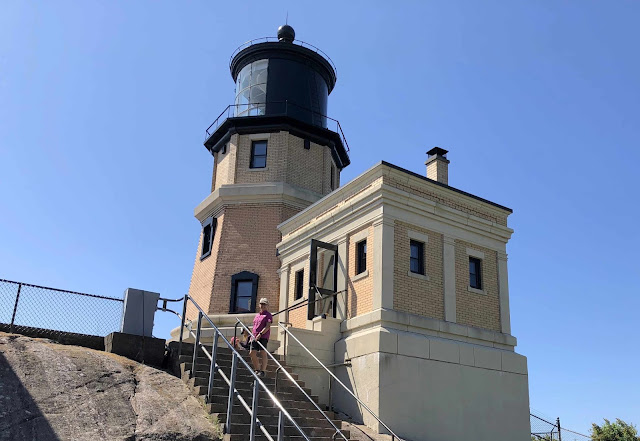
Just 8 more miles on Highway 61 brings us to another must-see stop. We paid for our tickets to tour Split Rock Lighthouse.
Split Rock was built after a large number of ships carrying iron ore sank near here. Our very entertaining guide told us that the Lake Superior sea bed is made up of that magnetic taconite that was driving the ships' compasses crazy. So the federal government supplied the money to build this lighthouse in 1909.
Our ticket allowed us to walk the steps up to the top of the lighthouse . . .
where we could see the large fresnel lens. This big lens magnifies the light beam to warn those directionally-challenged ships about the rocks here.
Speaking of big rocks, the lighthouse is built on a 130-foot rock over Lake Superior. Building it on such a pedestal meant they didn't need as many bricks for the light to still be seen 22 miles out in the lake.
From our vantage point at the lighthouse, we could see the shoreline, and the sparkling blue water of Lake Superior.
We could also see the air show being put on by two hawks. They were at our eye level as they met in the air.
Our tickets also included a tour through one of the three lightkeepers' houses, and the fog signal building that sounded a warning when needed on foggy days. When we headed down from our perch on that 130-foot cliff, we had lots of stairs between us and the beach.
There were plenty of boulders on the beach to keep a climber like Mark busy. After you see this zoomed picture of Mark on the boulder . . .
can you find him in the middle of the picture below?
Some of those rocks have been stacked into big and small rock cairns that line the beach area.
Whew! Split Rock Lighthouse was a long stop with lots of pictures! But we've got to get on down the road just nine more miles for our next stop at Gooseberry Falls. Highway 61 actually drives right over the multiple falls found here, and everyone makes a stop at this popular state park.
When we got to the Middle Falls, we found that they are covered with people enjoying the water on an unusually warm day.
But we found that by hiking a short distance to the Lower Falls, one could actually take a picture without anyone else in it!
Mark hiked all the way to the other side of the Upper Falls for another picture without the crowds. So even on a very busy tourist day at Gooseberry Falls, you can find some pristine views.
All this hiking and picture-taking has worked up an appetite, and it's past our lunch time. We stopped at the legendary "Betty's Pies," just 8 more miles down Highway 61. This 1950's style diner serves up great food, and we really enjoyed their special broasted chicken. But they are most famous for the 33,000 pies they make for their adoring public each year. We seldom take food pictures, but we made the exception for the Five Layer Chocolate Pie. The menu lists the five layers as pie crust, meringue, melted chocolate, cinnamon whipped cream, and chocolate whipped cream. We described it as five layers of delicious.
Now needing to walk off some more calories, we drive two miles further to the charming beach town of Two Harbors, Minnesota. It's a good day when you get pictures of more than one lighthouse. This is the handsome Two Harbors Light.
We also walked the long pier to get to the more industrial lighthouse at the end.
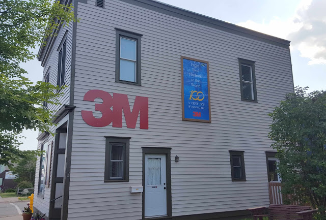
Some of our friends back in Weatherford, Oklahoma, probably know that this tiny town of Two Harbors was the birthplace of the giant 3M corporation. For many years, we had a 3M manufacturing plant in Weatherford. But the very first company headquarters were in this tiny two-story store front close to the harbor.
We also found this wood carving that looked familiar to us. Peter Toth made 50 of these hand-carved statues, one for each state. In our travels we have found others, and today we found Minnesota's statue in Two Harbors.
But we spent most of our time down at the town's harbor. Seeing how things work is fascinating to us, and there's a lot going on in the picture below. We'll break it down in layers.
The most obvious level is the tugboat in the foreground. This is the Edna G, who plied the waters of Lake Superior for years until her recent retirement.
At the very top of the picture is a railroad track. We watched as a train engine pushed a long row of cars onto the top of that rail. Then the crew went to each car, opening the base so the taconite would fall into the storage bins below. Notice that the car on the left is still full, while the one on the right was just emptied.

The third layer is harder to see, but a 700-foot-long ship is parked inside that loading dock. We can zoom in to see the white front of the ship, while it is being loaded with the taconite pellets. It was interesting that a man that had worked on one of these ships showed up while we were watching. He explained much of the process and described life on one of these big ships sailing Lake Superior.
We are obviously easily entertained. We sat at the harbor on this beautiful day until that entire train was unloaded, and the ship finished loading. Then the train backed down the track to get another load, and the ship began backing out of the dock.
Our new friend estimated this ship as a 700-footer. That's more than two football fields! He also pointed out how low the ship was sitting in the water, now that it was loaded to its maximum.
We saw the fourth layer of the harbor picture when we walked down the long pier at Two Harbors. A thousand-foot ship was waiting to be loaded on the other side of the dock. She was still empty and sitting high on the water. We noticed that on our own, since we are such knowledgeable sailors now.
Wow! What a day of sights to see along Highway 61 and the North Shore. We only drove 32 miles down this road, but it took us a very full day to wander through so many wonders!


If, by chance, you are heading into northern Michigan, you may want to consider a visit to the Soo Locks in Sault Ste. Marie. Based on how much you enjoyed the loading of that freighter, I think it's a pretty safe bet you'd be fascinated by the locks. If your researcher extraordinaire (that would be you, Mark!) checks the "Boat Nerd" web site, you'd be able to tell if there are any ships near the locks or currently locking through. In fact, if you knew the name of that freighter you were watching, you could probably track it via the Boat Nerd web site, as well. Have fun and travel safely!
ReplyDelete