We are trying to eat up all our groceries, so we are carbing up this morning with oatmeal and toast, then looking forward to a stop at a bakery in Homer. Who said we were going to lose weight with all this hiking? We are heading south on Sterling Highway towards Homer today, but our first stop was at the town of Anchor Point. We arrived at low tide to Halibut Campground and Recreation Area, to see what was happening on a normal morning here on the coast of the Cook Inlet. A 4-wheel-drive tractor had just launched a boat into the surf and was parking the long boat trailer . . .
and a group of six were fishing with one large net in the low tide water. We counted 36 eagles from one spot on the beach, and we must say this was a prettier spot than the dump we visited for yesterday’s eagle viewing. We moved to a different beach view, and took a picture of an eagle on the beach.
The eagle let us get closer . . .
and closer, until we got a surprisingly good picture even with our cell phones.
This salt water beach had more shells than we have seen in our Alaskan travels so far.
The Milepost had told us that this was the location of a specific sign, and Denisa was determined to find it. It took three circles through the campground, but we finally got pictorial proof that we were at the most westerly highway point in North America.
We were soon back on the highway, and the next sign picture at the hill just above the town of Homer. This one proclaims that Homer, Alaska, is the halibut fishing capital of the world. That is quite a claim considering we have taken pictures of some pretty big halibut at Seward and Valdez.
From our perch on Homer Hill, we can look across Cook Inlet, where the clouds are hanging on the mountains across the water.
Looking to the left, we can see the shadow of land jutting out into the water. That is the narrow strip of land that continues out into Kachemak Bay known as the Homer Spit. While Homer is the southern edge of the Kenai Peninsula, the Spit is truly the end of the road.
But our first priority in Homer is a stop at Two Sisters Bakery for our second round of breakfast carbs.
We started with a savory piece of quiche,
and ended with a lemon twist danish and a caramel nut sticky bun. All of them were very good!
Then we headed through town, and onto that 4.5-mile-long narrow strip of land called the Homer Spit. It formed naturally as a narrow peninsula into Kachemak Bay. From the very tip of the spit at Land's End, we could see the mountains. We had wanted to take a water taxi over to Kachemak Bay State Park for a five-mile hike, but we arrived too late to secure a taxi for today. We guess we'll just have to come back another year. We took a picture of the mountains that hold the Grewingk Glacier where we would have hiked.
A family of eagles was nesting on a radio tower at the end of the spit. We are sad that we don't have our good camera, but we made an attempt to take a picture through our binoculars. We got a picture of mom and dad standing guard over the single baby eagle in the nest.
Homer Spit is lined with stores and restaurants and interesting sights. We walked by some of the famous stops like the Salty Dog Saloon and Lighthouse, which has been here since 1898.
We peeked inside to see that the interior of the Salty Dog is decorated in dollar bills.
We made a stop at the Seafarer's Memorial, which honors those lost at sea.
From there we did a little beachcombing on the rocky beach of the spit.
Homer has had some viciously windy weather this week, that canceled all the boat rides and fishing charters. So even though it is cloudy, we feel like we had great weather for our visit.
As the clouds lifted, we got to see the tops of the mountains across Kachemak Bay. Homer is the jumping off place for air charters to Fort Clark National Park and Katmai National Park. Ferries that start at Homer take tourists to Kodiak Island, and other remote areas that can't be visited except by boat or air.
While we didn't find treasures on the beach, we did find flowers near the beach.
After thoroughly exploring the Homer Spit, we drove inland to see more of the town of Homer. The Milepost says that locals go to Bishop Beach, so that's where we started our hike through the Beluga Slough. Birds love this marshy grassland, and most of our trail is raised up over the marsh and on a boardwalk. As Denisa took this picture over the slough, she almost missed the 5-foot-tall sand hill crain in the middle foreground of the shot.
These marsh marigolds love the wet swampy ground here just like that sand hill crane.
The dandelions are huge in Alaska, almost the size of the palm of your hand,
and they attract a good-sized bumble bees as well. Even though the growing season is short, because the days are so long we are finding that things grow fast and big here.
As we left the town of Homer, we made a second stop on Homer Hill. The clouds have lifted since this morning, so we can see the mountains and Homer Spit more clearly this afternoon.
We had hurried to make the two-hour trip to Homer this morning, so on the way home we stopped at all the pull-outs and roadside attractions that we missed earlier. We stopped at milepost 142.5 and walked to the steep overlook for a clearer view of the volcanoes on the other side of the Cook Inlet.
These mountains are called "the ring of fire" because they are active volcanoes. They include Mount Illamna (at 10,016 feet) and Mount Redoubt (at 10,197 feet). Mount Redoubt had major eruptions from December 1989 through April 1990, and then again in 2009. All the volcanic ash in the air shut down air traffic in Alaska, so these mountains are not always as peaceful as they appear today.
Because of our high perch so far above the water . . .
we watched as bald eagles soared by at our eye level. It was cool when it happened once, and then we had a second fly-by as well!
Another great stop for seeing eagles was at Deep Creek State Recreation Area. We counted 24 eagles standing at this spot.
Deep Creek flows into Cook Outlet right here, and they are expecting the salmon to show up any day. The salmon will be swimming up Deep Creek to spawn at their childhood home, and the eagles are poised and ready for them.
We walked the beach . . .
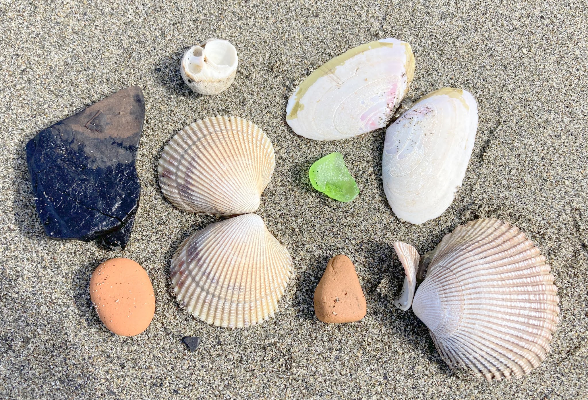
and found our first piece of Alaskan sea glass. That green glass is pictured between a few salt-water shells and rocks. The black chunk on the left is coal, a prominent part of the terrain here on Deep Creek Beach.
A stop in Ninilchick brought us to the Transfiguration of our Lord Russian Orthodox Church, with its gold onion-shaped domes.
The cemetery next door featured the same three-horizontal-bar crosses as the church. This cross is unique to the Russian Orthodox Church.
We stopped at this fish wier, but we weren't surprised that we didn't see any salmon. They count the fish making their way upstream here, and a signboard lists the counts for the day--zero.
Even though we didn't see salmon, we had plenty of wildlife sightings for the day. We saw hundreds of eagles, and we had seven moose sightings. It's funny that we didn't take the time to try to get a single picture of those moose. We well remember the excitement of seeing our first road-side moose three weeks ago, and today they have become commonplace. That is why the highways are filled with these moose warning signs because they are literally everywhere!
This is our last overnight in our cabin at Bella Haven Estates. In fact, it is our last night in Alaska. We had a good day visiting Homer and its Spit, and it feels like the three weeks have flown by!


Good
ReplyDeleteGood
ReplyDeleteLoved how this post beautifully captures the charm of Homer—from the stunning Homer Spit views to incredible wildlife moments, it truly brings Alaska to life.
ReplyDeleteMakes me dream of planning a Homer To Katmai adventure someday, especially after reading about it being a gateway to such unforgettable experiences!