After cooking a big breakfast of scrambled eggs, ham, and toast, we left our camp site that was a few miles north of Seward, Alaska. Based on the prices we see at restaurants here, we are saving lots of money by doing our own cooking. Of course, that also means we had to buy more ice and a few more groceries before we left Seward this morning. Our drive today will take us north on Seward Highway, along the lovely turquoise waters of Kenai Lake. This is a very big L-shaped lake, and we'll see it again today on a different highway.
The Milepost book listed a fish weir near Bear Lake, so we turned off to see if any salmon were making their way up the rivers here in the southern Kenai Peninsula. We found our first Milepost error, when it told us to turn west for the weir, instead of east. That might be the only mistake in the entire book. We were sad to see that the adult salmon are not yet returning to spawn, and the fish weir was empty. But we did get to see the tiny salmon fry in the big tank there. These babies were raised from harvested eggs gathered from salmon attempting to return to their birthplace. About three inches in length, they will take these little guys up the road to Bear Lake and that will "imprint" in their tiny salmon brains that this is the place they should come back to reproduce.
We also stopped in the tiny town of Moose Pass, where we had camped two nights ago. It's claim to fame is this water wheel that powers the grind stone in front of Denisa. A hand-painted sign says: Moose Pass is a peaceful little town, so if you have an axe to grind DO IT HERE!"
A little further down the road at Lily Pad Lake, we found a moose walking in the marsh. These moose-sighting are getting to be so common that we've stopped making u-turns for moose pictures. So this was the best Denisa could do on a drive-by shot.
Trumpeter Swans have just started arriving in Alaska this week. They spend the summers here, nesting and raising their young. These big birds use their long necks to feed on the vegetation at the bottom of the lake. Because of mineral content in the water, their necks and heads will sometimes be stained.
We are finding that many of the hikes we want to take are still icy, or perhaps the beginning of the trail is covered in snow so we couldn't drive the van to the trail head. But we found that the Carter Lake Trail is on the Seward Highway, and it has been reported that the snow is melting off the trail. So we parked the van and started our hike up the mountain. You are supposed to register before starting hikes into the mountains, and we noticed the last hiker from yesterday wrote "Trail impassable after 1/2 mile." We were questioning whether we should start a trail that was flooded at the very beginning, with water coming off the trail in a little waterfall.
But we've never been real smart about following hints, and we headed on up the very steep trail. It wasn't long before we found snow on the trail.
Sure enough, in a half-mile we found the impossible creek crossing. Actually, Mark made it across with dry feet, and then he tried adding some logs to make a walkway for Denisa. Then his stick broke and he ended up in the water. Should we continue, or head back to the van? We never have been very smart about keeping our feet dry, and we ended up just walking across this raging river.
Now we both have wet boots and socks, and we're seeing more snow on the trail.
It is a beautiful blue-sky day, with comfortable temperatures. That means that the icy snow is now becoming slush. It wasn't unusual to take a step and go through the icy crust all the way to our knees. But we never have been very smart about quitting a trail even when the conditions were questionable.
We thought that our first creek crossing was our only water crossing. But we were very wrong. We would actually find three more times when we would have to walk through ice water to continue. Have we mentioned that we never have been very smart about turning back?
On one of those water crossings, Denisa's foot broke through the snow and she landed in an unexpectedly deep creek. As she struggled to grasp anything to help pull her out, her hand found this vicious plant. As she wrapped her hand around the sharp spines of a plant that is aptly named "devil's club," she quickly forgot about her wet feet and started thinking about all the spiny thorns in her hand. We never have been very smart at quitting just because of a bad experience with the local flora.
The good news is that the elevation has leveled off, and we are no longer battling the steep section of the trail. Without all the snow, this would have been a very pleasantly level section as we neared the lake.
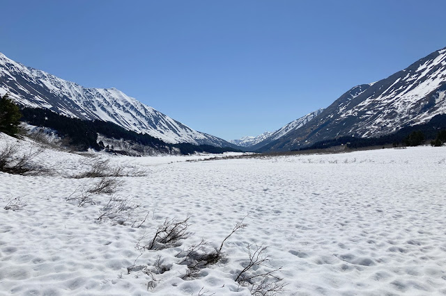
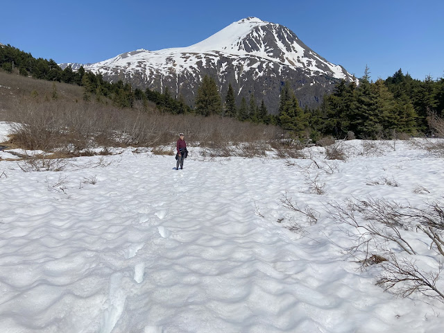
Well, we finally arrived! But Carter Lake is still iced over and hidden by snow in this beautiful valley. We had looked at pictures of this spot taken last summer, and this wasn't exactly the view we were hoping for.
Our cold feet were complaining, so we found a cleared spot under a tree and took off our wet boots and socks and let the sunshine dry our feet. We were obviously all alone on this snowy tundra, because no one else would be crazy enough to hike this far through those conditions. We sat here and ate our snacks while we warmed up. We both almost jumped and ran when there was a big noise and movement right beside us. When we started breathing again, we realized that one of the branches that had been weighted down by snow, had just melted enough to let the branch pop up and startle us.
It was a beautiful scene with the white snow and the blue sky in this big valley. You can barely see Denisa in the far right hand side of the picture below.
Now we had to convince our feet to get back into those wet socks and wet boots and make that long hike back to the van. The good news is that our feet aren't very smart, and they obliged as we headed back home. It was a long hike through the snow that was even less predictable as it continued to warm up. With every step, we didn't know if we would sink six inches or sixteen inches down into the drifts.
While we didn't see any wildlife on this trail, we found evidence of them in the lower sections. We found this fur first, and then a big hand-full of bear fur that we forgot to picture.
After over four miles in strenuous conditions, we wouldn't call the hike to Carter Lake a success. But we would call it an experience that we won't soon forget. Welcome to trying to hike in the mountains of Alaska in the spring! Back in the van, we were looking forward to dry socks and shoes. As we drove the van a few miles further north, we made a turn to the west at Tern Lake.
We found lots of terns and a few ducks at Tern Lake, but Denisa loves the loons.
We are now driving west on Sterling highway. We came to the highway bridge that divides Kenai River and Kenai Lake.
Remember the turquoise lake we saw earlier today, 30 miles away? That was the other end of Kenai Lake that starts right here at this bridge.
Looking the other direction, we see Kenai River, famous for some of the best salmon fishing in the world. We're too early for the salmon run, or this place would look quite different with wall-to-wall fishermen battling to catch the big ones. Today, we only watched as a family was unloading from a raft after their float down the river.
We will soon enter the Kenai National Wildlife Refuge, and Denisa has been having phone conversations with their visitor center for several weeks. We had talked about road conditions and the best hikes to take early in the season. For the best wildlife viewing and hiking, they recommended taking the alternate gravel road that parallels the highway. Since our rental camper van is allowed on gravel roads, we ignored the warning signs.
This gravel road was worse than the more-famous McCarthy Road that we have already conquered. We did get some great views of Skilak Lake on our drive.
Then the road took us through the ugly burned sections from the big fire of 2019. We didn't see any wildlife, and we probably wouldn't recommend this drive until the trees have a chance to rebound.
But we did find an open spot at one of the two free US Forest Service campgrounds. Lower Ohmer Lake Campground was full, but Lower Skilak had a couple spots still open. Spots here are free for up to 14 days. We talked to our neighbors on both sides, and they were all here to hunt morel mushrooms. We found that this soggy blackened area is great for mushrooming, and morels are supposed to be the best! Even though there are no hookups, this is our sixth free and beautiful camp site of this trip.
We were surrounded by mosquitoes! We had heard that people often say that the state bird of Alaska is the mosquito. They aren't kidding! These guys are big and aggressive!
It's the warmest day of our trip so far, and the first time it has been hot inside the van. So we were in a conundrum. Do we sit outside in the breeze and let the mosquitoes feast on our flesh? or sweat it out inside the van with the windows rolled up to keep the mosquitoes out? The good news is that the weather cooled quickly, and we only donated a little blood to the local mosquito population before it was comfortable to stay inside the van. After this little opportunity to experience Alaska mosquitoes, we are hoping that this wouldn't be repeated soon!
As we thought back over our adventures today, we have to say that this wasn't the ideal travel day--it started with hiking through snow drifts and ended with swatting mosquitoes. But we found some amazing Alaskan scenery between the two!


No comments:
Post a Comment